Postville, Newfoundland and Labrador
Postville (Inuttitut: KipukKak) is an Inuit town in the north of Labrador, Canada. It had a population of 177 as of 2016.[2] It is located about 40 km (25 mi) into the interior of Kaipokok Bay, 180 km (110 mi) NNE of Happy Valley-Goose Bay. Postville Airport is nearby.
Postville KipukKak[1] | |
|---|---|
Town | |
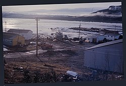 Postville, early June 1977 | |
| Nickname(s): The Post | |
 Postville Location of Postville | |
| Coordinates: 54°54′37″N 59°48′08″W | |
| Country | Canada |
| Province | Newfoundland and Labrador |
| Region | Nunatsiavut |
| Government | |
| • Mayor (AngajukKâk) | Glen Sheppard |
| • Federal MP | Yvonne Jones (L) |
| • Provincial MHA | Lela Evans (PC) |
| • Nunatsiavut Assembly member | Tyler Edmunds (I) |
| Area | |
| • Total | 1.98 km2 (0.76 sq mi) |
| Elevation | 68 m (223 ft) |
| Population (2016)[2] | |
| • Total | 177 |
| • Density | 89.4/km2 (232/sq mi) |
| Time zone | UTC−04:00 (AST) |
| • Summer (DST) | UTC−03:00 (ADT) |
| Area code(s) | 709 |
References
- https://inuktutlexicon.gcrc.carleton.ca/index.html?module=module.inuktutlexicon_word_list#eyJ0IjoieCIsImkiOiIyZjUyOGFkZjY0MzNiMGIxZjJmNzE1NThiYjAzZmYxMSIsInMiOjE1ODEyOTE2MDA1NDd9
- "Postville, Town [Census subdivision], Newfoundland and Labrador and Division No. 11, Census division [Census division], Newfoundland and Labrador". www12.statcan.gc.ca. Government of Canada. Retrieved April 1, 2020.
This article is issued from Wikipedia. The text is licensed under Creative Commons - Attribution - Sharealike. Additional terms may apply for the media files.