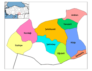
Nizip
Nizip, Ottoman Turkish: نزيب,[3] is a district and city[4] of Gaziantep Province of southeastern Turkey.
Nizip Tilm | |
|---|---|
 Nizip | |
| Coordinates: 37°00′36″N 37°47′50″E | |
| Country | Turkey |
| Province | Gaziantep |
| Government | |
| • Mayor | Hacı Fevzi Akdoğan (AKP) |
| • Kaymakam | Yaşar Karadeniz |
| Area | |
| • District | 1,046.25 km2 (403.96 sq mi) |
| Population (2012)[2] | |
| • Urban | 100,488 |
| • District | 135,819 |
| • District density | 130/km2 (340/sq mi) |
| Post code | 27700 |
| Website | www.nizip.bel.tr |
As of 2010, the population of the city is 96,229. It is located 45 km from the city of Gaziantep, 95 km from Şanlıurfa (Edessa), and 35 km from Karkamış, which is an old city also known historically as Carchemish.
History
It is quite near to the ancient Roman cities of Zeugma and Rumkale, which means Roman Castle. The city is commonly confused with Nusaybin because both cities had similar ancient names, which are Nisibis and Nisibin. Even in very credible encyclopedias there appear some confusions. Indeed, while Nizip is near the Euphrates river, Nusaybin is near the Tigris river. In excavation sites, valuable mosaics have been found, including those of Triton, Dionysos' Wedding, Poseidon, Perseus, Gypsy Girl or Gaia, Dolphin and Eros, Physke, Akhilleus, Aphrodite's Birth, and Europa.
In 1839, the Ottoman Empire and Egypt, which was being ruled by Muhammad Ali of Egypt (otherwise known as Muhammad Ali Pasha), went to war in the countryside of Nizip on June 24, 1839. Because of that, the war was called the Battle of Nezib.
See also
Gallery
 Nizip Town
 Nizip Town view
 Nizip Mosque
 Nizip Arched road
 Nizip Architectural sight
 Nizip Architectural detail
 Nizip Fevkanı church
 Nizip Fevkanı church
 Nizip Fevkanı church
References
- "Area of regions (including lakes), km²". Regional Statistics Database. Turkish Statistical Institute. 2002. Retrieved 2013-03-05.
- "Population of province/district centers and towns/villages by districts - 2012". Address Based Population Registration System (ABPRS) Database. Turkish Statistical Institute. Retrieved 2013-02-27.
- Tahir Sezen and in kurdish Tilm Osmanlı Yer Adları (Alfabetik Sırayla), T.C. Başbakanlık Devlet Arşivleri Genel Müdürlüğü, Yayın Nu 21, Ankara, p. 385.
- "Gaziantep (Turkey): Districts, Cities, Towns and Villages - Population Statistics in Maps and Charts".
