New Hanover Township, Montgomery County, Pennsylvania
New Hanover Township is a township in Montgomery County, Pennsylvania, United States. The population was 10,939 at the 2010 census.
New Hanover Township | |
|---|---|
Long Meadow Farmhouse, a historic site in the township | |
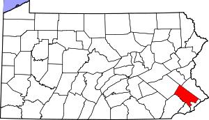
 Location of New Hanover Township in Montgomery County | |
.svg.png) Location of PA in the United States | |
| Coordinates: 40°19′31″N 75°32′53″W | |
| Country | United States |
| State | Pennsylvania |
| County | Montgomery |
| Established | 1741 |
| Area | |
| • Total | 21.68 sq mi (56.2 km2) |
| • Land | 21.68 sq mi (56.2 km2) |
| • Water | 0.00 sq mi (0.0 km2) |
| Elevation | 427 ft (130 m) |
| Population (2010) | |
| • Total | 10,939 |
| • Estimate (2016)[2] | 12,776 |
| • Density | 500/sq mi (190/km2) |
| Time zone | UTC-5 (EST) |
| • Summer (DST) | UTC-4 (EDT) |
| Area code(s) | 610, 484 and 215, 267 and 445 |
| Website | www |
Geography
According to the United States Census Bureau, the township has a total area of 21.6 square miles (55.9 km2), all of it land. It consists mainly of rolling hills and valleys and is drained by the Schuylkill River mostly via the Perkiomen Creek. Its villages include Fagleysville, Frederick (also in Upper Frederick Township,) Hoffmansville, Layfield, New Hanover, New Hanover Square, and Sassamansville (also in Douglass Township.) Its numbered routes are 73 east-to-west and 663 north-to-south, which join briefly in Layfield.
New Hanover has a hot-summer humid continental climate (Dfa) and is in hardiness zones 6b and 7a. The average monthly temperatures in Layfield range from 30.6° F in January to 75.3° F in July. The average annual absolute minimum temperature in Layfield is 0.6° F.
Adjacent municipalities
- Upper Hanover Township (northeast)
- Upper Frederick Township (east)
- Limerick Township (southeast)
- Lower Pottsgrove Township (south)
- Upper Pottsgrove Township (southwest)
- Douglass Township (northwest)
Demographics
| Historical population | |||
|---|---|---|---|
| Census | Pop. | %± | |
| 1930 | 1,467 | — | |
| 1940 | 1,476 | 0.6% | |
| 1950 | 1,745 | 18.2% | |
| 1960 | 3,218 | 84.4% | |
| 1970 | 4,211 | 30.9% | |
| 1980 | 4,623 | 9.8% | |
| 1990 | 5,956 | 28.8% | |
| 2000 | 7,369 | 23.7% | |
| 2010 | 10,939 | 48.4% | |
| Est. 2016 | 12,776 | [2] | 16.8% |
| [3] | |||
As of the 2010 census, the township was 95.3% White, 1.2% Black or African American, 0.1% Native American, 2.0% Asian, and 1.2% were two or more races. 1.6% of the population were of Hispanic or Latino ancestry.[4]
As of the census[5] of 2000, there were 7,369 people, 2,532 households, and 2,147 families residing in the township. The population density was 341.3 people per square mile (131.8/km2). There were 2,615 housing units at an average density of 121.1/sq mi (46.8/km2). The racial makeup of the township was 98.32% White, 0.31% African American, 0.07% Native American, 0.79% Asian, 0.01% Pacific Islander, 0.05% from other races, and 0.45% from two or more races. Hispanic or Latino of any race were 0.76% of the population.
There were 2,532 households, out of which 40.1% had children under the age of 18 living with them, 76.5% were married couples living together, 5.4% had a female householder with no husband present, and 15.2% were non-families. 12.2% of all households were made up of individuals, and 5.1% had someone living alone who was 65 years of age or older. The average household size was 2.91 and the average family size was 3.17.
In the township the population was spread out, with 27.5% under the age of 18, 5.3% from 18 to 24, 31.5% from 25 to 44, 24.9% from 45 to 64, and 10.8% who were 65 years of age or older. The median age was 38 years. For every 100 females there were 100.2 males. For every 100 females age 18 and over, there were 97.7 males.
The median income for a household in the township was $67,097, and the median income for a family was $70,789. Males had a median income of $51,420 versus $33,578 for females. The per capita income for the township was $25,084. About 1.3% of families and 3.3% of the population were below the poverty line, including 4.7% of those under age 18 and 1.4% of those age 65 or over.
Government and politics
| Year | Republican | Democratic |
|---|---|---|
| 2012 | 56.3% 2,870 | 42.1% 2,143 |
| 2008 | 51.2% 2,514 | 47.9% 2,352 |
| 2004 | 56.5% 2,398 | 43.0% 1,825 |
| 2000 | 55.7% 1,655 | 41.3% 1,225 |
| 1996 | 49.2% 1,173 | 36.1% 861 |
| 1992 | 42.1% 1,026 | 30.8% 751 |
Board of Supervisors
New Hanover is a second-class township and elects five at-large supervisors
- Charles Garner Jr. - Chair
- Kurt Zebrowski - Vice Chair
- Marie Livelsberger
- William Ross
- Boone Flint
References
- "2016 U.S. Gazetteer Files". United States Census Bureau. Retrieved Aug 14, 2017.
- "Population and Housing Unit Estimates". Retrieved June 9, 2017.
- "Archived copy". Archived from the original on 2019-04-09. Retrieved 2014-03-21.CS1 maint: archived copy as title (link)
- https://www.usatoday.com/news/nation/census/profile/PA
- "U.S. Census website". United States Census Bureau. Retrieved 2008-01-31.
External links
| Wikimedia Commons has media related to New Hanover Township, Montgomery County, Pennsylvania. |
