Netawaka Township, Jackson County, Kansas
Netawaka Township is a township in Jackson County, Kansas, USA. As of the 2000 census, its population was 361.
Netawaka Township | |
|---|---|
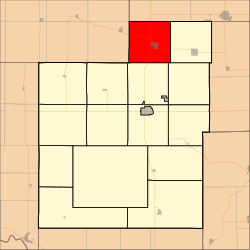 Location in Jackson County | |
| Coordinates: 39°36′25″N 95°43′01″W | |
| Country | United States |
| State | Kansas |
| County | Jackson |
| Area | |
| • Total | 36.09 sq mi (93.48 km2) |
| • Land | 36.04 sq mi (93.35 km2) |
| • Water | 0.05 sq mi (0.12 km2) 0.13% |
| Elevation | 1,132 ft (345 m) |
| Population (2000) | |
| • Total | 361 |
| • Density | 10/sq mi (3.9/km2) |
| GNIS feature ID | 0473236 |
History
Netawaka Township was formerly occupied by the Kickapoo Tribe in Kansas, until they were removed to a reservation in Brown County. It was bought by the Union Pacific Railroad in 1870 and opened for settlement.[1] Netawaka Township was formed in 1871.[2] Netawaka is a Native American name meaning "fair view".[3]
Geography
Netawaka Township covers an area of 36.09 square miles (93.48 square kilometers); of this, 0.05 square miles (0.12 square kilometers) or 0.13 percent is water. The streams of Mosquito Creek and Wolfley Creek run through this township.
Cities and towns
Adjacent townships
- Powhattan Township, Brown County (north)
- Whiting Township (east)
- Straight Creek Township (southeast)
- Liberty Township (south)
- Jefferson Township (southwest)
- Wetmore Township, Nemaha County (west)
- Granada Township, Nemaha County (northwest)
Major highways
- U.S. Route 75
- K-9
gollark: Interesting idea. I think the code technically already would allow this with no changes.
gollark: I really should work out how to reasonably handle people setting reminders with times in the past.
gollark: I could somehow build time delayed commands into the reminder system.
gollark: That could be a cool feature for my bot!
gollark: Newer-generation ones are actually moderately usable. My laptop's one from some years ago runs Minecraft fine.
References
- Barr, Elizabeth N. (1907). Business directory and history of Jackson County. p. 33.
- Barr, Elizabeth N. (1907). Business directory and history of Jackson County. p. 13.
- Blackmar, Frank Wilson (1912). Kansas: A Cyclopedia of State History, Volume 2. Standard Publishing Company. pp. 354.
External links
Municipalities and communities of Jackson County, Kansas, United States | ||
|---|---|---|
| Cities | 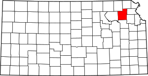 Map of Kansas highlighting Jackson County | |
| Unincorporated communities | ||
| Indian reservations | ||
| Townships | ||
| Footnotes | ‡This populated place also has portions in an adjacent county or counties | |
This article is issued from Wikipedia. The text is licensed under Creative Commons - Attribution - Sharealike. Additional terms may apply for the media files.