Banner Township, Jackson County, Kansas
Banner Township is a township in Jackson County, Kansas, USA. As of the 2000 census, its population was 300. The southernmost part of the township is located within the Prairie Band Potawatomi Indian Reservation.
Banner Township | |
|---|---|
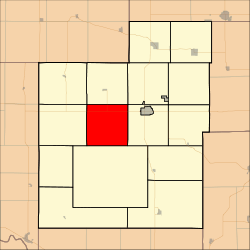 Location in Jackson County | |
| Coordinates: 39°26′00″N 95°50′56″W | |
| Country | United States |
| State | Kansas |
| County | Jackson |
| Area | |
| • Total | 36.02 sq mi (93.28 km2) |
| • Land | 35.76 sq mi (92.62 km2) |
| • Water | 0.25 sq mi (0.65 km2) 0.7% |
| Elevation | 1,296 ft (395 m) |
| Population (2000) | |
| • Total | 300 |
| • Density | 8.4/sq mi (3.2/km2) |
| GNIS feature ID | 0478185 |
Geography
Banner Township covers an area of 36.02 square miles (93.28 square kilometers); of this, 0.25 square miles (0.65 square kilometers) or 0.7 percent is water.
Adjacent townships
- Jefferson Township (north)
- Liberty Township (northeast)
- Franklin Township (east)
- Lincoln Township (south)
- Grant Township (west)
- Soldier Township (northwest)
Cemeteries
The township contains one cemetery, Hass.
Major highways
gollark: Observe, our end gateway research facility.
gollark: There's one under spawn I think.
gollark: That would be silly. We need to know positions just like everyone else, and you can't use the command computer getBlockPosition thing on a neural interface.
gollark: What about the secret GTech™ dimension accessible only via our hacked end gateway?
gollark: This is not actually working for me.
References
External links
Municipalities and communities of Jackson County, Kansas, United States | ||
|---|---|---|
| Cities | 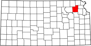 Map of Kansas highlighting Jackson County | |
| Unincorporated communities | ||
| Indian reservations | ||
| Townships | ||
| Footnotes | ‡This populated place also has portions in an adjacent county or counties | |
This article is issued from Wikipedia. The text is licensed under Creative Commons - Attribution - Sharealike. Additional terms may apply for the media files.