Grant Township, Jackson County, Kansas
Grant Township is a township in Jackson County, Kansas, USA. As of the 2000 census, its population was 212. The southeasternmost part of the township is located within the Prairie Band Potawatomi Indian Reservation.
Grant Township | |
|---|---|
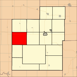 Location in Jackson County | |
| Coordinates: 39°26′30″N 95°57′31″W | |
| Country | United States |
| State | Kansas |
| County | Jackson |
| Area | |
| • Total | 42 sq mi (108.77 km2) |
| • Land | 41.95 sq mi (108.66 km2) |
| • Water | 0.04 sq mi (0.11 km2) 0.1% |
| Elevation | 1,184 ft (361 m) |
| Population (2000) | |
| • Total | 212 |
| • Density | 5.1/sq mi (2/km2) |
| GNIS feature ID | 1729694 |
History
Grant Township was formed in 1870.[1]
Geography
Grant Township covers an area of 42 square miles (108.77 square kilometers); of this, 0.04 square miles (0.11 square kilometers) or 0.1 percent is water.
Adjacent townships
- Soldier Township (north)
- Jefferson Township (northeast)
- Banner Township (east)
- Lincoln Township (southeast)
- Adrian Township (south)
- St. Clere Township, Pottawatomie County (southwest)
- Lincoln Township, Pottawatomie County (west)
- Grant Township, Pottawatomie County (northwest)
Cemeteries
The township contains two cemeteries: Boan and Olive Hill.
Major highways
gollark: /ignore
gollark: It just crashes nsh hosts or something.
gollark: I tried to make something which broadcasts potatOS install commands over nsh, but it works not.
gollark: PotatoS can't be remotely installed, unless you run something really insecure.
gollark: __***yes***__
References
- Barr, Elizabeth N. (1907). Business directory and history of Jackson County. p. 13.
External links
Municipalities and communities of Jackson County, Kansas, United States | ||
|---|---|---|
| Cities | 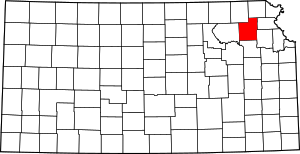 Map of Kansas highlighting Jackson County | |
| Unincorporated communities | ||
| Indian reservations | ||
| Townships | ||
| Footnotes | ‡This populated place also has portions in an adjacent county or counties | |
This article is issued from Wikipedia. The text is licensed under Creative Commons - Attribution - Sharealike. Additional terms may apply for the media files.