Powhattan Township, Brown County, Kansas
Powhattan Township is a township in Brown County, Kansas, USA. As of the 2000 census, its population was 874.
Powhattan Township | |
|---|---|
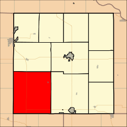 Location in Brown County | |
| Coordinates: 39°42′48″N 095°41′11″W | |
| Country | United States |
| State | Kansas |
| County | Brown |
| Area | |
| • Total | 89.82 sq mi (232.63 km2) |
| • Land | 89.76 sq mi (232.49 km2) |
| • Water | 0.05 sq mi (0.14 km2) 0.06% |
| Elevation | 1,096 ft (334 m) |
| Population (2000) | |
| • Total | 874 |
| • Density | 9.7/sq mi (3.8/km2) |
| GNIS feature ID | 0472964 |
Geography
Powhattan Township covers an area of 89.82 square miles (232.6 km2) and contains one incorporated settlement, Powhattan. According to the USGS, it contains two cemeteries: Powhattan and Powhattan.
The streams of Plum Creek, Pony Creek, Roys Creek and Squaw Creek run through this township.
Transportation
Powhattan Township contains one airport or landing strip, Croxton Airport.
gollark: <@184468521042968577> Shatter suggestion: a function for displaying a terminal state snapshot in some format on a supplied canvas.
gollark: Again: what terminal streaming implementations are there?
gollark: I assume for a big object you'd just figure out the directions for the corners and figure out whether the click was between them?
gollark: I'll just Google it when I actually need to do it.
gollark: I know roughly what it is, I just have no idea how to implement it.
External links
Municipalities and communities of Brown County, Kansas, United States | ||
|---|---|---|
| Cities |  Map of Kansas highlighting Brown County | |
| CDPs | ||
| Unincorporated communities | ||
| Indian reservations | ||
| Townships | ||
| Footnotes | ‡This populated place also has portions in an adjacent county or counties | |
This article is issued from Wikipedia. The text is licensed under Creative Commons - Attribution - Sharealike. Additional terms may apply for the media files.