National Register of Historic Places listings in Watauga County, North Carolina
This list includes properties and districts listed on the National Register of Historic Places in Watauga County, North Carolina. Click the "Map of all coordinates" link to the right to view a Google map of all properties and districts with latitude and longitude coordinates in the table below.[1]
Current location
- This National Park Service list is complete through NPS recent listings posted August 14, 2020.[2]
| [3] | Name on the Register[4] | Image | Date listed[5] | Location | City or town | Description |
|---|---|---|---|---|---|---|
| 1 | Blair Farm | 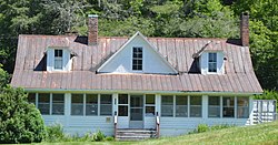 Blair Farm |
August 29, 2008 (#08000812) |
N. side of NC 1522 just W. of its jct. with Blairmont Dr. 36°12′11″N 81°38′52″W |
Boone | |
| 2 | Bollinger-Hartley House | March 9, 1995 (#95000172) |
423 N. Main St. 36°08′19″N 81°40′13″W |
Blowing Rock | ||
| 3 | Cove Creek High School | 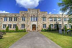 Cove Creek High School |
June 18, 1998 (#98000707) |
207 Dale Adams Rd. 36°15′47″N 81°47′07″W |
Sugar Grove | |
| 4 | Daniel Boone Hotel | 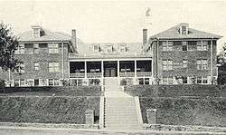 Daniel Boone Hotel |
December 27, 1982 (#82001307) |
W. King St. 36°13′06″N 81°40′57″W |
Boone | Demolished[6] |
| 5 | East Tennessee & Western North Carolina Railroad Locomotive No. 12 | March 12, 1992 (#92000147) |
Tweetsie RR theme park, jct. of Tweetsie RR Rd. and US 321 36°10′14″N 81°38′51″W |
Blowing Rock | ||
| 6 | Ben Farthing Farm | January 4, 1993 (#92001736) |
NC 1121 (Rominger Rd.) W side, just N of Watauga R. 36°14′21″N 81°49′26″W |
Sugar Grove | ||
| 7 | Flat Top Estate | .jpg) Flat Top Estate |
December 24, 2013 (#13000978) |
Blue Ridge Parkway, milepost 292.8 to 295.5 36°08′53″N 81°41′36″W |
Blowing Rock | |
| 8 | Former Randall Memorial Building | March 14, 1991 (#91000263) |
Greenway Ct. 36°07′55″N 81°40′40″W |
Blowing Rock | ||
| 9 | Gragg House | October 25, 1973 (#73001382) |
On U.S. 221 36°07′00″N 81°46′39″W |
Blowing Rock | ||
| 10 | Green Park Historic District | 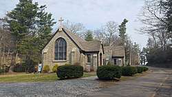 Green Park Historic District |
August 19, 1994 (#94001020) |
Jct. of US 321 and Green Hill and Rock Rds. 36°07′17″N 81°39′38″W |
Blowing Rock | |
| 11 | Green Park Inn | 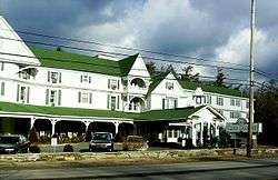 Green Park Inn |
June 3, 1982 (#82004637) |
U.S. 321 36°07′07″N 81°39′39″W |
Blowing Rock | |
| 12 | Jones House | 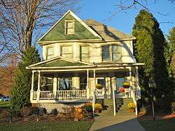 Jones House |
March 25, 1987 (#87000483) |
604 W. King St. 36°13′06″N 81°41′00″W |
Boone | |
| 13 | Mast Farm | 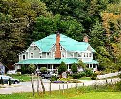 Mast Farm |
January 20, 1972 (#72001002) |
E of Valle Crucis off SR 1112 36°12′23″N 81°46′15″W |
Valle Crucis | |
| 14 | Mast General Store | 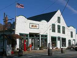 Mast General Store |
April 3, 1973 (#73001383) |
S of Valle Crucis on SR 1112 36°12′28″N 81°46′48″W |
Valle Crucis | |
| 15 | John Smith Miller House | 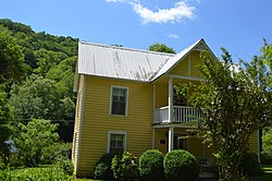 John Smith Miller House |
January 29, 2009 (#08001389) |
561 Chestnut Grove Rd. 36°15′59″N 81°39′48″W |
Boone | |
| 16 | US Post Office-Boone | 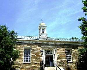 US Post Office-Boone |
January 11, 1996 (#95001521) |
679 W. King St. 36°13′11″N 81°41′10″W |
Boone | |
| 17 | Valle Crucis Episcopal Mission | 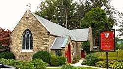 Valle Crucis Episcopal Mission |
September 9, 1993 (#93000938) |
NC 194 N side, 1 miles SW of jct. with NC 1112 36°11′45″N 81°47′46″W |
Valle Crucis | |
| 18 | Valle Crucis Historic District | 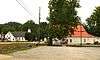 Valle Crucis Historic District |
February 2, 2005 (#04001600) |
Along NC 194 and NC 1112 36°12′33″N 81°46′43″W |
Valle Crucis | |
| 19 | Vardell Family Cottages Historic District | March 12, 2001 (#01000254) |
222 Grandfather Ave, 137, 187, 209 Chestnut Circle 36°07′36″N 81°40′42″W |
Blowing Rock | ||
| 20 | Ward Family House |  Ward Family House |
May 23, 1997 (#97000473) |
8018 Rominger Rd. 36°14′50″N 81°49′21″W |
Sugar Grove | |
| 21 | Westglow | August 13, 1979 (#79001762) |
W of Blowing Rock on U.S. 221 36°08′17″N 81°42′50″W |
Blowing Rock | ||
| 22 | Wilson-Vines House | December 22, 1997 (#97001562) |
4300 Rush Branch Rd. 36°17′30″N 81°50′57″W |
Beaver Dam |
gollark: Solution: only support USB flash drives for storage.
gollark: There's CraftOS-EFI, which is neat, but limited in use as it cannot do HTTP.
gollark: *cue long rant about UEFI*
gollark: What do you think of UEFI?
gollark: That sounds like an implementation detail. Implementation details are BEES.
See also
| Wikimedia Commons has media related to National Register of Historic Places in Watauga County, North Carolina. |
References
- The latitude and longitude information provided in this table was derived originally from the National Register Information System, which has been found to be fairly accurate for about 99% of listings. Some locations in this table may have been corrected to current GPS standards.
- "National Register of Historic Places: Weekly List Actions". National Park Service, United States Department of the Interior. Retrieved on August 14, 2020.
- Numbers represent an ordering by significant words. Various colorings, defined here, differentiate National Historic Landmarks and historic districts from other NRHP buildings, structures, sites or objects.
- "National Register Information System". National Register of Historic Places. National Park Service. April 24, 2008.
- The eight-digit number below each date is the number assigned to each location in the National Register Information System database, which can be viewed by clicking the number.
- "North Carolina Listings in the National Register of Historic Places by County". North Carolina State Historic Preservation Office. 22 October 2008. Archived from the original on 30 November 2012. Retrieved 14 July 2009.

| Topics | |
|---|---|
| Lists by state |
|
| Lists by insular areas | |
| Lists by associated state | |
| Other areas | |
| Related | |
| |
Municipalities and communities of Watauga County, North Carolina, United States | ||
|---|---|---|
| Towns | Watauga County map | |
| CDPs | ||
| Unincorporated communities |
| |
| Footnotes | ‡This populated place also has portions in an adjacent county or counties | |
This article is issued from Wikipedia. The text is licensed under Creative Commons - Attribution - Sharealike. Additional terms may apply for the media files.