National Register of Historic Places listings in Lee County, North Carolina
This list includes properties and districts listed on the National Register of Historic Places in Lee County, North Carolina. Click the "Map of all coordinates" link to the right to view an online map of all properties and districts with latitude and longitude coordinates in the table below.[1]
Current listings
- This National Park Service list is complete through NPS recent listings posted August 14, 2020.[2]
| [3] | Name on the Register[4] | Image | Date listed[5] | Location | City or town | Description |
|---|---|---|---|---|---|---|
| 1 | Buffalo Presbyterian Church and Cemeteries | 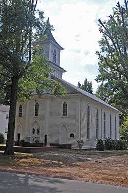 Buffalo Presbyterian Church and Cemeteries |
February 5, 1999 (#99000090) |
1333 Carthage St. 35°27′40″N 79°11′37″W |
Sanford | |
| 2 | Downtown Sanford Historic District | 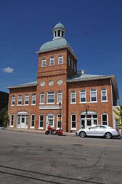 Downtown Sanford Historic District |
September 28, 1985 (#85002561) |
Roughly bounded by Gordon St., Horner Blvd., Cole and Chatham Sts. 35°28′49″N 79°10′42″W |
Sanford | |
| 3 | East Sanford Historic District |  East Sanford Historic District |
December 28, 2010 (#10001096) |
Bounded roughly by Charlotte Ave., Goldsboro Ave., N. 1st St., S. 2nd St., and S. 8th St. 35°28′48″N 79°10′08″W |
Sanford | |
| 4 | Endor Iron Furnace | August 13, 1974 (#74001358) |
SE of Cumnock 35°33′01″N 79°13′28″W |
Cumnock | ||
| 5 | Euphronia Presbyterian Church | 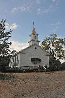 Euphronia Presbyterian Church |
May 26, 1994 (#94000527) |
3800 Steel Bridge Rd. 35°28′17″N 79°20′51″W |
Sanford | |
| 6 | Farish-Lambeth House | March 1, 2002 (#02000111) |
6308 Deep River Rd. 35°36′52″N 79°07′00″W |
Sanford | ||
| 7 | Obediah Farrar House | August 18, 1993 (#93000728) |
9910 Barringer Rd. 35°36′07″N 79°04′27″W |
Haywood | ||
| 8 | Former Sanford High School |  Former Sanford High School |
November 29, 1995 (#95001400) |
507 N. Steele St. 35°29′08″N 79°11′04″W |
Sanford | |
| 9 | Hawkins Avenue Historic District | 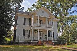 Hawkins Avenue Historic District |
July 5, 2000 (#00000771) |
Roughly bounded by Hill Ave., First St., Charlotte Ave., and Horner Blvd. 35°29′10″N 79°10′50″W |
Sanford | |
| 10 | Lee Avenue Historic District | 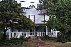 Lee Avenue Historic District |
September 6, 2002 (#02000944) |
Roughly along Lee Avenue, W. Main St., S. Academy St., and W. Raleigh St. 35°27′19″N 79°09′12″W |
Sanford | |
| 11 | Lee County Courthouse | 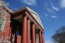 Lee County Courthouse |
May 10, 1979 (#79001729) |
Horner Blvd., between Courtland and McIntosh Sts. 35°28′01″N 79°09′49″W |
Sanford | |
| 12 | Lee County Training School | 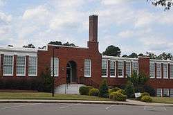 Lee County Training School |
December 28, 2000 (#00001551) |
806 S. Vance St. 35°28′25″N 79°10′58″W |
Sanford | |
| 13 | John D. McIver Farm | 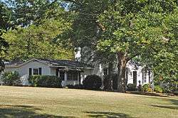 John D. McIver Farm |
August 18, 1993 (#93000729) |
2007 Windmill Dr. 35°29′38″N 79°12′30″W |
Sanford | |
| 14 | Railroad House | 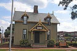 Railroad House |
January 29, 1973 (#73001355) |
Carthage St. at Hawkins Ave. 35°28′50″N 79°10′39″W |
Sanford | |
| 15 | Rosemount-McIver Park Historic District | 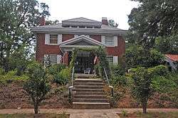 Rosemount-McIver Park Historic District |
March 21, 1997 (#97000255) |
Roughly bounded by N. Horner Blvd., N. Vance and Carthage Sts. 35°28′50″N 79°11′09″W |
Sanford | |
| 16 | Sanford Tobacco Company Redrying Plant and Warehouse | August 27, 2019 (#100004323) |
521 Wicker St. 35°28′35″N 79°11′01″W |
Sanford | ||
| 17 | Seaboard Milling Company | 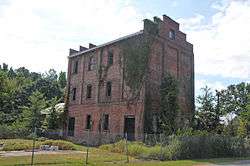 Seaboard Milling Company |
May 2, 2002 (#02000440) |
202 Hickory Ave. 35°28′41″N 79°10′22″W |
Sanford | |
| 18 | Temple Theatre |  Temple Theatre |
September 8, 1983 (#83001895) |
120 Carthage St. 35°28′52″N 79°10′44″W |
Sanford |
gollark: I can't really tell, but it seems laggier than I'd expect on my e-web connection.
gollark: You can redo the halloween whatsit?
gollark: I vote for a dragon which is literally a pure white rectangle.
gollark: 2G prizes are typically considered worth more than that, probably, so I don't know.
gollark: How can you be bothered to mouseover all the eggs to check their codes?
See also
| Wikimedia Commons has media related to National Register of Historic Places in Lee County, North Carolina. |
References
- The latitude and longitude information provided in this table was derived originally from the National Register Information System, which has been found to be fairly accurate for about 99% of listings. Some locations in this table may have been corrected to current GPS standards.
- "National Register of Historic Places: Weekly List Actions". National Park Service, United States Department of the Interior. Retrieved on August 14, 2020.
- Numbers represent an ordering by significant words. Various colorings, defined here, differentiate National Historic Landmarks and historic districts from other NRHP buildings, structures, sites or objects.
- "National Register Information System". National Register of Historic Places. National Park Service. April 24, 2008.
- The eight-digit number below each date is the number assigned to each location in the National Register Information System database, which can be viewed by clicking the number.

| Topics | |
|---|---|
| Lists by state |
|
| Lists by insular areas | |
| Lists by associated state | |
| Other areas | |
| Related | |
| |
Municipalities and communities of Lee County, North Carolina, United States | ||
|---|---|---|
| City | | |
| Town | ||
| Unincorporated communities | ||
| Footnotes | ‡This populated place also has portions in an adjacent county or counties | |
This article is issued from Wikipedia. The text is licensed under Creative Commons - Attribution - Sharealike. Additional terms may apply for the media files.