National Register of Historic Places listings in Cherokee County, North Carolina
This list includes properties and districts listed on the National Register of Historic Places in Cherokee County, North Carolina. Click the "Map of all coordinates" link to the right to view an online map of all properties and districts with latitude and longitude coordinates in the table below.[1]
Current listings
- This National Park Service list is complete through NPS recent listings posted August 14, 2020.[2]
| [3] | Name on the Register | Image | Date listed[4] | Location | City or town | Description |
|---|---|---|---|---|---|---|
| 1 | Apalachia Hydroelectric Project | 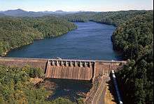 Apalachia Hydroelectric Project |
October 26, 2017 (#100001459) |
Apalachia Dam Rd. 35°10′04″N 84°17′44″W |
Murphy | |
| 2 | John C. Campbell Folk School Historic District | .jpg) John C. Campbell Folk School Historic District |
August 22, 1983 (#83001839) |
Off U.S. Route 64 35°02′10″N 83°57′54″W |
Brasstown | |
| 3 | Cherokee County Courthouse | .jpg) Cherokee County Courthouse |
May 10, 1979 (#79001692) |
75 Peachtree Street 35°05′12″N 84°01′59″W |
Murphy | |
| 4 | John Franklin Cobb House | October 11, 1984 (#84000074) |
U.S. Routes 19/129 35°00′07″N 84°05′04″W |
Bell View | ||
| 5 | Hiwassee Hydroelectric Project |  Hiwassee Hydroelectric Project |
August 11, 2017 (#100001460) |
600 Powerhouse Rd. 35°09′04″N 84°10′40″W |
Murphy | |
| 6 | Robert Lafayette Cooper House | .jpg) Robert Lafayette Cooper House |
September 5, 1990 (#90001372) |
70 Campbell St. 35°05′14″N 84°01′50″W |
Murphy | |
| 7 | Franklin Pierce Cover House | .jpg) Franklin Pierce Cover House |
November 12, 1982 (#82001293) |
177 Wilson Street 35°12′07″N 83°49′37″W |
Andrews | |
| 8 | First Baptist Church | .jpg) First Baptist Church |
September 14, 2002 (#02000962) |
101 Chestnut St. 35°12′00″N 83°49′31″W |
Andrews | |
| 9 | Harshaw Chapel and Cemetery | .jpg) Harshaw Chapel and Cemetery |
April 5, 1984 (#84001979) |
150 Church Street 35°05′07″N 84°02′01″W |
Murphy | |
| 10 | Walker's Inn | .jpg) Walker's Inn |
August 19, 1975 (#75001247) |
South of Andrews on NC 1505 off NC 19 and 1393 35°11′35″N 83°48′16″W |
Andrews |
gollark: Okay.
gollark: Really? Screenshot or something? Perhaps it is just captchaous.
gollark: They have no real way to verify it.
gollark: Just add fake information.
gollark: Potentially, yes.
See also
| Wikimedia Commons has media related to National Register of Historic Places in Cherokee County, North Carolina. |
References
- The latitude and longitude information provided in this table was derived originally from the National Register Information System, which has been found to be fairly accurate for about 99% of listings. Some locations in this table may have been corrected to current GPS standards.
- "National Register of Historic Places: Weekly List Actions". National Park Service, United States Department of the Interior. Retrieved on August 14, 2020.
- Numbers represent an ordering by significant words. Various colorings, defined here, differentiate National Historic Landmarks and historic districts from other NRHP buildings, structures, sites or objects.
- The eight-digit number below each date is the number assigned to each location in the National Register Information System database, which can be viewed by clicking the number.

| Topics | |
|---|---|
| Lists by state |
|
| Lists by insular areas | |
| Lists by associated state | |
| Other areas | |
| Related | |
| |
Municipalities and communities of Cherokee County, North Carolina, United States | ||
|---|---|---|
| Towns | | |
| CDP | ||
| Unincorporated communities | ||
| Indian reservation | ||
| Footnotes | ‡This populated place also has portions in an adjacent county or counties | |
This article is issued from Wikipedia. The text is licensed under Creative Commons - Attribution - Sharealike. Additional terms may apply for the media files.