National Register of Historic Places listings in Stokes County, North Carolina
This list includes properties and districts listed on the National Register of Historic Places in Stokes County, North Carolina. Click the "Map of all coordinates" link to the right to view a Google map of all properties and districts with latitude and longitude coordinates in the table below.[1]
Current listings
- This National Park Service list is complete through NPS recent listings posted August 14, 2020.[2]
| [3] | Name on the Register[4] | Image | Date listed[5] | Location | City or town | Description |
|---|---|---|---|---|---|---|
| 1 | Christ Episcopal Church |  Christ Episcopal Church |
January 28, 2005 (#04001586) |
412 Summit Ave. 36°18′00″N 80°08′22″W |
Walnut Cove | |
| 2 | Danbury Historic District | 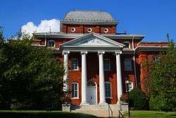 Danbury Historic District |
July 15, 1986 (#86001686) |
Main St. between Danbury Cemetery Rd. and NC 89 36°24′30″N 80°12′24″W |
Danbury | |
| 3 | R. W. George Mill | 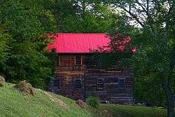 R. W. George Mill |
October 10, 1997 (#97001199) |
NC 89, 0.6 mi NE of jct. of NC 89 and NC 66 36°29′33″N 80°23′33″W |
Francisco | |
| 4 | Germanton Methodist Church and Cemetery | March 19, 1998 (#98000259) |
Main St., jct. of Main St. and Willow St. 36°15′39″N 80°14′00″W |
Germanton | ||
| 5 | Hanging Rock State Park Bathhouse | 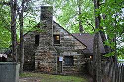 Hanging Rock State Park Bathhouse |
October 24, 1991 (#91001507) |
End of NC 2015 S of jct. with NC 1001, Hanging Rock State Park 36°23′25″N 80°16′10″W |
Danbury | |
| 6 | Jessup's Mill | 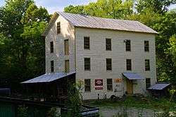 Jessup's Mill |
July 15, 1982 (#82003515) |
1565 Collinstown Road 36°31′32″N 80°22′17″W |
Collinstown | |
| 7 | King Historic District | 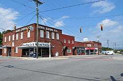 King Historic District |
September 6, 2002 (#02000941) |
Dalton Rd., Main St., School St. and Railroad Right of Way 36°16′50″N 80°21′33″W |
King | |
| 8 | Leak-Chaffin-Browder House | September 6, 2002 (#02000943) |
NC 8, 0.1 miles S of jct. with NC 1941 36°16′33″N 80°13′14″W |
Germanton | ||
| 9 | Matthew Moore House | 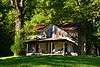 Matthew Moore House |
October 29, 1974 (#74001375) |
W of Danbury 36°26′06″N 80°17′32″W |
Moores Springs | |
| 10 | Moratock Iron Furnace | 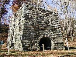 Moratock Iron Furnace |
July 30, 1974 (#74001376) |
East of Danbury off North Carolina Highway 89 36°24′32″N 80°11′49″W |
Danbury | |
| 11 | Pine Hall | 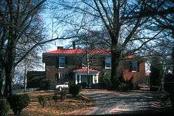 Pine Hall |
July 16, 1979 (#79003350) |
SR 1901 and NC 772 36°19′40″N 80°02′31″W |
Pine Hall | |
| 12 | Rock House | 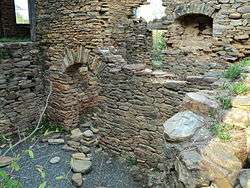 Rock House |
October 1, 1975 (#75001292) |
N of King on SR 1186 36°24′17″N 80°21′44″W |
King | |
| 13 | St. Philip's Episcopal Church | 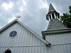 St. Philip's Episcopal Church |
July 15, 1982 (#82003516) |
NC 65 and 8 and SR 1957 36°15′35″N 80°14′11″W |
Germanton | |
| 14 | Stokes County Courthouse | .jpg) Stokes County Courthouse |
May 10, 1979 (#79001750) |
Main St. between North St. and Courthouse Rd. 36°24′34″N 80°12′22″W |
Danbury | |
| 15 | Walnut Cove Colored School |  Walnut Cove Colored School |
February 24, 1995 (#95000161) |
Jct. of Brook and Dalton Sts., NW corner 36°18′12″N 80°08′39″W |
Walnut Cove |
gollark: They were talking about 4K/60Hz, which would require some very impressive compression.
gollark: I don't think it actually *could* work, given the low latency and high bandwidth necessary for *gaming*.
gollark: Orders of Magnitude does more of the "mystery" stuff, but is also very weird.
gollark: https://cyberlaw.stanford.edu/blog/2020/01/earn-it-act-how-ban-end-end-encryption-without-actually-banning-it
gollark: Which doesn't explicitly forbid E2E, but of course if you can't *see* what people are sending it might be EVIL CONTENT!!!!
See also
| Wikimedia Commons has media related to National Register of Historic Places in Stokes County, North Carolina. |
References
- The latitude and longitude information provided in this table was derived originally from the National Register Information System, which has been found to be fairly accurate for about 99% of listings. Some locations in this table may have been corrected to current GPS standards.
- "National Register of Historic Places: Weekly List Actions". National Park Service, United States Department of the Interior. Retrieved on August 14, 2020.
- Numbers represent an ordering by significant words. Various colorings, defined here, differentiate National Historic Landmarks and historic districts from other NRHP buildings, structures, sites or objects.
- "National Register Information System". National Register of Historic Places. National Park Service. April 24, 2008.
- The eight-digit number below each date is the number assigned to each location in the National Register Information System database, which can be viewed by clicking the number.

| Topics | |
|---|---|
| Lists by state |
|
| Lists by insular areas | |
| Lists by associated state | |
| Other areas | |
| Related | |
| |
Municipalities and communities of Stokes County, North Carolina, United States | ||
|---|---|---|
| City |
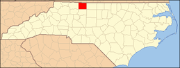
| Stokes County map |
| Towns | ||
| Village | ||
| Townships | ||
| CDPs | ||
| Other unincorporated communities |
| |
| Footnotes | ‡This populated place also has portions in an adjacent county or counties. | |
This article is issued from Wikipedia. The text is licensed under Creative Commons - Attribution - Sharealike. Additional terms may apply for the media files.