National Register of Historic Places listings in Davidson County, North Carolina
This list includes properties and districts listed on the National Register of Historic Places in Davidson County, North Carolina. Click the "Map of all coordinates" link to the right to view an online map of all properties and districts with latitude and longitude coordinates in the table below.[1]
Current listings
- This National Park Service list is complete through NPS recent listings posted August 14, 2020.[2]
| [3] | Name on the Register[4] | Image | Date listed[5] | Location | City or town | Description |
|---|---|---|---|---|---|---|
| 1 | Abbott's Creek Primitive Baptist Church Cemetery | July 10, 1984 (#84001982) |
SR 1743 36°00′20″N 80°05′01″W |
Thomasville | ||
| 2 | Adderton-Badgett House | July 10, 1984 (#84001988) |
SR 2529 35°34′02″N 80°08′36″W |
Denton | ||
| 3 | Beallmont | July 10, 1984 (#84001991) |
SR 1133 35°44′51″N 80°20′23″W |
Linwood | ||
| 4 | Beck's Reformed Church Cemetery |  Beck's Reformed Church Cemetery |
July 10, 1984 (#84001992) |
SR 2250 35°45′29″N 80°13′33″W |
Lexington | |
| 5 | Bethany Reformed and Lutheran Church Cemetery | July 10, 1984 (#84001994) |
SR 1716 35°57′25″N 80°09′50″W |
Midway | ||
| 6 | Beulah Church of Christ Cemetery | July 10, 1984 (#84001995) |
SR 1457 35°53′17″N 80°16′43″W |
Welcome | ||
| 7 | Brummell's Inn | November 25, 1980 (#80002822) |
North of Thomasville 35°56′55″N 80°06′17″W |
Thomasville | ||
| 8 | Chapel Hill Church Tabernacle | April 24, 2012 (#12000235) |
1457 Chapel Hill Church Rd. 35°33′13″N 80°04′16″W |
Denton | ||
| 9 | Church Street School | Church Street School |
March 1, 1990 (#90000355) |
Jasper St., West of Church St. 35°53′21″N 80°05′21″W |
Thomasville | |
| 10 | Emanuel United Church of Christ Cemetery | 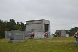 Emanuel United Church of Christ Cemetery |
July 10, 1984 (#84001997) |
SR 2060 35°50′34″N 80°06′56″W |
Thomasville | |
| 11 | Erlanger Mill Village Historic District |  Erlanger Mill Village Historic District |
January 9, 2008 (#07001371) |
Roughly bounded by Winston Rd., Short, 7th, Hames, 2nd, Rainbow, Park Circle, and Olympia Sts. 35°50′23″N 80°15′20″W |
Lexington | |
| 12 | Hamilton Everhart Farm | July 10, 1984 (#84002000) |
US 52 35°55′46″N 80°13′31″W |
Midway | ||
| 13 | Riley Everhart Farm and General Store | July 10, 1984 (#84002001) |
SR 1468 35°53′30″N 80°16′28″W |
Arnold | ||
| 14 | Fair Grove Methodist Church Cemetery | 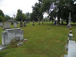 Fair Grove Methodist Church Cemetery |
July 10, 1984 (#84002004) |
NC 109, SR 2072 and 2070 35°51′05″N 80°04′42″W |
South Thomasville | |
| 15 | T. Austin and Ernestine L. Finch House |  T. Austin and Ernestine L. Finch House |
August 26, 2019 (#100004321) |
17 E. Main St. 35°52′58″N 80°04′48″W |
Thomasville | |
| 16 | First Reformed Church |  First Reformed Church |
April 28, 2000 (#00000417) |
22 E. Center S. 35°49′25″N 80°15′08″W |
Lexington | |
| 17 | Good Hope Methodist Church Cemetery | July 10, 1984 (#84002007) |
Junction of NC 150 and SR 1445 35°55′45″N 80°20′11″W |
Welcome | ||
| 18 | Grace Episcopal Church |  Grace Episcopal Church |
December 20, 2006 (#06001138) |
419 S. Main St. 35°49′13″N 80°15′26″W |
Lexington | |
| 19 | Grimes Brothers Mill | 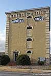 Grimes Brothers Mill |
May 2, 2002 (#02000443) |
2 North State St. 35°49′31″N 80°15′17″W |
Lexington | |
| 20 | Grimes School | 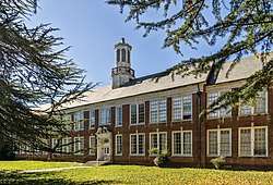 Grimes School |
December 28, 1988 (#88002832) |
Hege Dr. 35°50′00″N 80°15′22″W |
Lexington | |
| 21 | Grimes-Crotts Mill | July 10, 1984 (#84002008) |
SR 1445 35°55′13″N 80°22′15″W |
Reedy Creek | ||
| 22 | Haden Place | July 10, 1984 (#84002009) |
SR 1156 35°45′56″N 80°21′34″W |
Tyro | ||
| 23 | Hampton House | July 10, 1984 (#84002025) |
SR 483 35°56′47″N 80°22′17″W |
Arcadia | ||
| 24 | Hedrick's Grove Reformed Church | January 31, 2008 (#07001496) |
3840 Allred Rd. 35°46′18″N 80°10′48″W |
Lexington | ||
| 25 | Dr. William Rainey Holt House |  Dr. William Rainey Holt House |
June 23, 1983 (#83001876) |
408 S. Main St. 35°49′15″N 80°15′27″W |
Lexington | |
| 26 | Jersey Baptist Church Cemetery | July 10, 1984 (#84002027) |
SR 1272 35°43′57″N 80°18′43″W |
Linwood | ||
| 27 | Jersey Settlement Meeting House | July 10, 1984 (#84002032) |
SR 1272 35°43′55″N 80°18′42″W |
Linwood | ||
| 28 | Junior Order United American Mechanics National Orphans Home | July 10, 1984 (#84002034) |
NC 8 35°45′49″N 80°16′38″W |
Lexington | ||
| 29 | Capt. John Koonts, Jr., Farm | July 10, 1984 (#84002131) |
SR 1186 35°50′43″N 80°22′59″W |
Tyro | ||
| 30 | Shadrach Lambeth House | 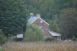 Shadrach Lambeth House |
July 10, 1984 (#84002135) |
SR 2062 35°51′24″N 80°03′19″W |
Thomasville | |
| 31 | Lexington Industrial Historic District | 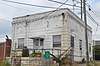 Lexington Industrial Historic District |
May 15, 2019 (#100003927) |
Roughly bounded by E. 1st and S. Salisbury Sts., the North Carolina Railroad corridor, and Wennonah Cotton Mill village's western lot lines 35°49′22″N 80°15′06″W |
Lexington | |
| 32 | Lexington Memorial Hospital | 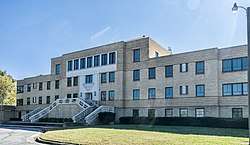 Lexington Memorial Hospital |
May 24, 2012 (#12000313) |
111 North Carolina Ave. 35°48′35″N 80°14′53″W |
Lexington | |
| 33 | Lexington Residential Historic District | 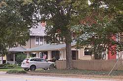 Lexington Residential Historic District |
April 19, 2007 (#07000350) |
Roughly bounded by State St., W. 5th St., Martin St., Westside Dr., Southbound St., and W. 9th Ave. 35°49′34″N 80°15′34″W |
Lexington | |
| 34 | Mitchell House | Mitchell House |
September 20, 2000 (#00001121) |
411 Biggs Ave. 35°52′39″N 80°05′38″W |
Thomasville | |
| 35 | Eli Moore House | July 10, 1984 (#84002137) |
SR 1741 35°58′52″N 80°03′41″W |
High Point | ||
| 36 | Mor-Val Hosiery Mill | October 5, 2001 (#01001074) |
N. Main and E. 1st Sts. 35°38′04″N 80°06′49″W |
Denton | ||
| 37 | Mount Ebal Methodist Protestant Church | July 10, 1984 (#84002143) |
End of SR 2518 35°37′34″N 80°04′05″W |
Denton | ||
| 38 | Old Davidson County Courthouse | 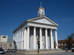 Old Davidson County Courthouse |
June 24, 1971 (#71000576) |
Main and Center Sts. 35°49′30″N 80°15′13″W |
Lexington | |
| 39 | Pilgrim Reformed Church Cemetery | July 10, 1984 (#84002145) |
SR 1843 35°51′10″N 80°13′03″W |
Lexington | ||
| 40 | Randolph Street Historic District | 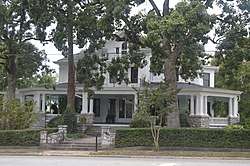 Randolph Street Historic District |
August 28, 2012 (#12000571) |
100-200 blocks of Randolph St., & 10 W. Colonial Dr. 35°52′48″N 80°04′51″W |
Thomasville | |
| 41 | Reid Farm | January 25, 1979 (#79001700) |
West of Jackson Hill on SR 2537 35°34′10″N 80°11′58″W |
Jackson Hill | ||
| 42 | Salem Street Historic District | 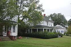 Salem Street Historic District |
August 9, 2006 (#06000688) |
108-301 Salem St., 6-12 Forsyth St., and 6 Leonard St. 35°53′19″N 80°05′02″W |
Thomasville | |
| 43 | Henry Shoaf Farm |  Henry Shoaf Farm |
July 13, 1984 (#84002148) |
NC 64 35°50′07″N 80°16′49″W |
Lexington | |
| 44 | Smith Clinic | 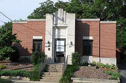 Smith Clinic |
November 29, 1991 (#91001746) |
17 Randolph St. 35°52′54″N 80°04′51″W |
Thomasville | |
| 45 | Philip Sowers House | November 25, 1980 (#80002821) |
SR 1162 35°47′30″N 80°27′40″W |
Churchland | ||
| 46 | Adam Spach Rock House Site | June 14, 2002 (#02000643) |
Address Restricted |
Winston-Salem | ||
| 47 | Spring Hill Methodist Protestant Church Cemetery | July 10, 1984 (#84002151) |
SR 1755 35°58′15″N 80°03′20″W |
High Point | ||
| 48 | Spurgeon House | 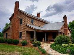 Spurgeon House |
April 20, 1983 (#83001877) |
West of High Point 35°59′15″N 80°05′19″W |
High Point | |
| 49 | St. Luke's Lutheran Church Cemetery | July 10, 1984 (#84002147) |
SR 1183 35°49′00″N 80°22′32″W |
Tyro | ||
| 50 | Thomasville Downtown Historic District |  Thomasville Downtown Historic District |
September 1, 2005 (#05000940) |
Roughly bounded by Main St., Trade St., Guilford St. and Commerce St. 35°53′00″N 80°04′53″W |
Thomasville | |
| 51 | Thomasville Railroad Passenger Depot | 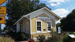 Thomasville Railroad Passenger Depot |
July 9, 1981 (#81000423) |
W. Main St. 35°52′57″N 80°05′00″W |
Thomasville | |
| 52 | Tyro Tavern | August 16, 1984 (#84002154) |
NC 150 35°48′23″N 80°22′37″W |
Tyro | ||
| 53 | Uptown Lexington Historic District | 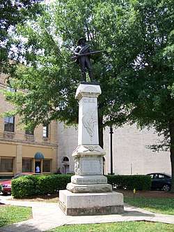 Uptown Lexington Historic District |
May 16, 1996 (#96000570) |
Main St. from 3rd Ave. to 2nd St. 35°49′24″N 80°15′15″W |
Lexington | |
| 54 | Waggoner Graveyard | July 10, 1984 (#84002158) |
SR 1814 35°55′21″N 80°11′46″W |
Welcome | ||
| 55 | George W. Wall House | July 10, 1984 (#84002161) |
NC 109 and SR 1723 36°00′35″N 80°08′31″W |
Wallburg | ||
| 56 | John Henry Welborn House |  John Henry Welborn House |
July 10, 1984 (#84002163) |
511 S. Main St. 35°49′09″N 80°15′29″W |
Lexington | Destroyed 1990;[6] |
| 57 | Yadkin College Historic District | February 25, 1988 (#88000165) |
Northern and southern sides of SR 1194 west of SR 1436 35°52′32″N 80°22′56″W |
Yadkin College |
gollark: Perl has a cryoapiocity of 22π, see.
gollark: Yes.
gollark: The osmarks.tk™ lorem ipsum page, obviously.
gollark: Also, a web crawler which finds Perl scripts.
gollark: For projects needing a consistent stream of random values I also have a bunch of simulations of web developers using vim.
See also
| Wikimedia Commons has media related to National Register of Historic Places in Davidson County, North Carolina. |
References
- The latitude and longitude information provided in this table was derived originally from the National Register Information System, which has been found to be fairly accurate for about 99% of listings. Some locations in this table may have been corrected to current GPS standards.
- "National Register of Historic Places: Weekly List Actions". National Park Service, United States Department of the Interior. Retrieved on August 14, 2020.
- Numbers represent an ordering by significant words. Various colorings, defined here, differentiate National Historic Landmarks and historic districts from other NRHP buildings, structures, sites or objects.
- "National Register Information System". National Register of Historic Places. National Park Service. April 24, 2008.
- The eight-digit number below each date is the number assigned to each location in the National Register Information System database, which can be viewed by clicking the number.
- "North Carolina Listings in the National Register of Historic Places by County". North Carolina State Historic Preservation Office. 22 October 2008. Archived from the original on 30 November 2012. Retrieved 14 July 2009.

| Topics | |
|---|---|
| Lists by state |
|
| Lists by insular areas | |
| Lists by associated state | |
| Other areas | |
| Related | |
| |
Municipalities and communities of Davidson County, North Carolina, United States | ||
|---|---|---|
| Cities | | |
| Towns | ||
| CDPs | ||
| Unincorporated communities | ||
| Footnotes | ‡This populated place also has portions in an adjacent county or counties | |
This article is issued from Wikipedia. The text is licensed under Creative Commons - Attribution - Sharealike. Additional terms may apply for the media files.