Somerset, New York
Somerset is a town in Niagara County, New York, United States. The population was 2,662 at the 2010 census. The town is believed to be named after Somerset, New Jersey, the source of some early settlers.
Somerset, New York | |
|---|---|
Town | |
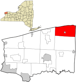
 Location in Niagara County and the state of New York. | |
 Somerset, New York Location in Niagara County and the state of New York. | |
| Coordinates: 43°20′12″N 78°32′46″W | |
| Country | United States |
| State | New York |
| County | Niagara |
| Government | |
| • Type | Town Council |
| • Town Supervisor | Daniel Engert (R) |
| • Town Council | Members' List
|
| Area | |
| • Total | 37.17 sq mi (96.27 km2) |
| • Land | 37.11 sq mi (96.11 km2) |
| • Water | 0.06 sq mi (0.16 km2) |
| Elevation | 328 ft (100 m) |
| Population (2010) | |
| • Total | 2,662 |
| • Estimate (2016)[2] | 2,579 |
| • Density | 69.50/sq mi (26.83/km2) |
| Time zone | UTC-5 (Eastern (EST)) |
| • Summer (DST) | UTC-4 (EDT) |
| FIPS code | 36-68330 |
| GNIS feature ID | 0979504 |

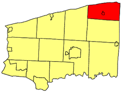
The Town of Somerset is in the northeast corner of the county and is northeast of the City of Niagara Falls.
History
The Town of Somerset was established in 1823 from a section of the Town of Hartland. Part of Somerset was used later to form the Town of Newfane.
The Thirty Mile Point Light is listed on the National Register of Historic Places.[3]
Geography
According to the United States Census Bureau, the town has a total area of 37.2 square miles (96 km2), of which, 37.2 square miles (96 km2) of it is land and 0.1 square miles (0.26 km2) of it (0.19%) is water.
Somerset borders Lake Ontario on the north and Orleans County, New York on the east.
Adjacent cities and towns
- Town of Hartland - south
- Town of Newfane - west
- Orleans County, Town of Ridgeway - east
- Lake Ontario - north
Major highways in the Town of Somerset


Demographics
| Historical population | |||
|---|---|---|---|
| Census | Pop. | %± | |
| 1830 | 871 | — | |
| 1840 | 1,742 | 100.0% | |
| 1850 | 2,154 | 23.7% | |
| 1860 | 2,132 | −1.0% | |
| 1870 | 1,862 | −12.7% | |
| 1880 | 2,015 | 8.2% | |
| 1890 | 1,962 | −2.6% | |
| 1900 | 1,923 | −2.0% | |
| 1910 | 2,260 | 17.5% | |
| 1920 | 2,003 | −11.4% | |
| 1930 | 1,892 | −5.5% | |
| 1940 | 2,041 | 7.9% | |
| 1950 | 2,227 | 9.1% | |
| 1960 | 2,489 | 11.8% | |
| 1970 | 2,677 | 7.6% | |
| 1980 | 2,701 | 0.9% | |
| 1990 | 2,655 | −1.7% | |
| 2000 | 2,865 | 7.9% | |
| 2010 | 2,662 | −7.1% | |
| Est. 2016 | 2,579 | [2] | −3.1% |
| U.S. Decennial Census[4] | |||
As of the census[5] of 2000, there were 2,865 people, 1,000 households, and 786 families residing in the town. The population density was 77.1 people per square mile (29.8/km2). There were 1,132 housing units at an average density of 30.5 per square mile (11.8/km2). The racial makeup of the town was 97.07% White, 0.73% African American, 0.66% Native American, 0.52% Asian, 0.45% from other races, and 0.56% from two or more races. Hispanic or Latino of any race were 1.29% of the population.
There were 1,000 households, out of which 38.3% had children under the age of 18 living with them, 65.1% were married couples living together, 8.1% had a female householder with no husband present, and 21.3% were non-families. 17.3% of all households were made up of individuals, and 8.4% had someone living alone who was 65 years of age or older. The average household size was 2.85 and the average family size was 3.18.
In the town, the population was spread out, with 29.5% under the age of 18, 6.9% from 18 to 24, 27.8% from 25 to 44, 23.9% from 45 to 64, and 11.9% who were 65 years of age or older. The median age was 37 years. For every 100 females, there were 106.0 males. For every 100 females age 18 and over, there were 101.9 males.
The median income for a household in the town was $44,216, and the median income for a family was $49,583. Males had a median income of $39,583 versus $20,508 for females. The per capita income for the town was $17,792. About 8.2% of families and 10.1% of the population were below the poverty line, including 16.4% of those under age 18 and 3.8% of those age 65 or over.
Communities and locations in Somerset

- Barker – The Village of Barker, centrally located in the town.
- County Line – A hamlet on the east town line by Routes NY-18 and NY-269. The community is shared with Orleans County, New York.
- Golden Hill State Park – A state park on the shore of Lake Ontario in the northeast part of the town.
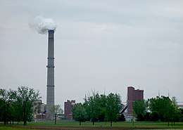
- Kintigh Generating Station – A power generating station on Lake Ontario northwest of Barker.
- Millers – A hamlet by the eastern town line at NY-269, shared with the town of Yates in Orleans County.
- Somerset – A hamlet north of Barker on Lake Road (NY-18) and Quaker Road (NY-148).
- South Somerset – A hamlet at Somerset Road and Town Line Road.
- West Somerset – A hamlet west of Barker on West Somerset Road at Hosmer Road.
Adjacent towns and areas
The northern border is Lake Ontario with Canada on the opposite shore. The eastern border is the Town of Yates in Orleans County. The south border is the Town of Hartland, and the west border is the Town of Newfane.
References
- "2016 U.S. Gazetteer Files". United States Census Bureau. Retrieved Jul 5, 2017.
- "Population and Housing Unit Estimates". Retrieved June 9, 2017.
- "National Register Information System". National Register of Historic Places. National Park Service. April 15, 2008.
- "Census of Population and Housing". Census.gov. Retrieved June 4, 2015.
- "U.S. Census website". United States Census Bureau. Retrieved 2008-01-31.
