National Register of Historic Places listings in Buchanan County, Iowa
This is a list of the National Register of Historic Places listings in Buchanan County, Iowa.
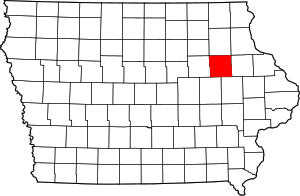
Location of Buchanan County in Iowa
This is intended to be a complete list of the properties and districts on the National Register of Historic Places in Buchanan County, Iowa, United States. Latitude and longitude coordinates are provided for many National Register properties and districts; these locations may be seen together in a map.[1]
There are 20 properties and districts listed on the National Register in the county.
- This National Park Service list is complete through NPS recent listings posted August 14, 2020.[2]
Current listings
| [3] | Name on the Register[4] | Image | Date listed[5] | Location | City or town | Description |
|---|---|---|---|---|---|---|
| 1 | 280th Street Bridge | 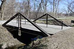 280th Street Bridge |
June 25, 1998 (#98000756) |
280th St. over an unnamed stream 42°23′06″N 91°56′34″W |
Independence | |
| 2 | Buchanan County Court House | 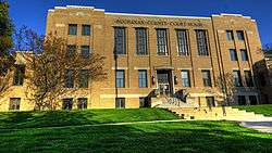 Buchanan County Court House |
August 28, 2003 (#03000820) |
216 5th Ave. 42°28′14″N 91°53′21″W |
Independence | PWA Moderne-style courthouse built in 1940. |
| 3 | Fisher-Plane Commercial Building | 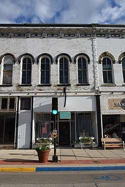 Fisher-Plane Commercial Building |
March 8, 1997 (#97000212) |
119 and 121 1st St., E. 42°28′07″N 91°53′35″W |
Independence | |
| 4 | Mathias C. and Eva B. Crowell Fuhrman Farm | 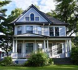 Mathias C. and Eva B. Crowell Fuhrman Farm |
May 1, 1998 (#97000213) |
1780 185th St. 42°30′47″N 91°55′44″W |
Independence | |
| 5 | Captain Daniel S. and Fannie L. (Brooks) Lee House | _Lee_House.jpg) Captain Daniel S. and Fannie L. (Brooks) Lee House |
January 7, 2010 (#09001203) |
803 1st St. East 42°28′08″N 91°53′06″W |
Independence | |
| 6 | Maas Commercial Building | 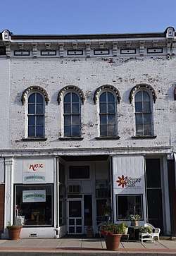 Maas Commercial Building |
August 14, 1998 (#98001047) |
209 1st St., E. 42°28′01″N 91°53′35″W |
Independence | |
| 7 | Malek Theatre | 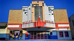 Malek Theatre |
May 21, 2009 (#09000329) |
116 2nd Ave. NE 42°28′10″N 91°53′36″W |
Independence | |
| 8 | Erza McKenzie Round Barn |  Erza McKenzie Round Barn |
June 30, 1986 (#86001419) |
Off Iowa Highway 150 42°36′26″N 91°56′07″W |
Hazleton | |
| 9 | Munson Building | 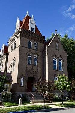 Munson Building |
November 21, 1976 (#76000736) |
210 2nd St., NE. 42°28′14″N 91°53′44″W |
Independence | |
| 10 | Robert R. and Julia L. Plane House |  Robert R. and Julia L. Plane House |
August 27, 1999 (#99001030) |
301 3rd Ave., SE. 42°27′58″N 91°53′31″W |
Independence | |
| 11 | Pleasant Grove Presbyterian Church | .jpg) Pleasant Grove Presbyterian Church |
October 4, 2017 (#100001697) |
601 State St. 42°32′01″N 92°01′23″W |
Chatham | |
| 12 | Eliphalet W. and Catherine E. Jaquish Purdy House | 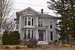 Eliphalet W. and Catherine E. Jaquish Purdy House |
March 7, 1996 (#96000237) |
215 3rd Ave., SW. 42°28′01″N 91°53′48″W |
Independence | |
| 13 | Richardson-Jakway House |  Richardson-Jakway House |
June 27, 1985 (#85001382) |
Rural Route #1 42°35′04″N 91°43′26″W |
Aurora | |
| 14 | Dr. Judd C. and Margaret S. Clarke Shellito House | 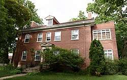 Dr. Judd C. and Margaret S. Clarke Shellito House |
January 16, 1997 (#96001588) |
310 5th Ave., SE. 42°27′58″N 91°53′20″W |
Independence | |
| 15 | State Savings Bank | .jpg) State Savings Bank |
August 27, 1999 (#99001031) |
103 N. Water St. 42°23′40″N 91°45′41″W |
Quasqueton | |
| 16 | Taylor's Ford Bridge | 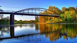 Taylor's Ford Bridge |
June 25, 1998 (#98000755) |
Nolen Ave. over the Wapsipinicon River 42°23′58″N 91°48′46″W |
Independence | |
| 17 | Lowell E. Walter House | Lowell E. Walter House |
March 2, 1983 (#83000345) |
Off Quasqueton Diagonal Boulevard northwest of Quasqueton 42°24′31″N 91°46′11″W |
Quasqueton | Preserved within Cedar Rock State Park. |
| 18 | Wapsipinicon Mill |  Wapsipinicon Mill |
April 21, 1975 (#75000678) |
100 1st St., W. 42°28′08″N 91°53′53″W |
Independence | |
| 19 | Wapsipinicon River Bridge | 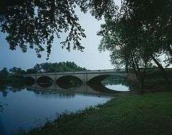 Wapsipinicon River Bridge |
June 25, 1998 (#98000758) |
Iowa Highway 150 over the Wapsipinicon River 42°27′31″N 91°53′27″W |
Independence | |
| 20 | Weins Commercial Building | 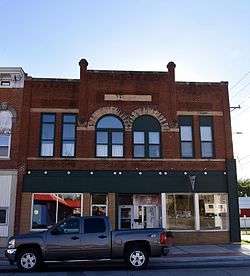 Weins Commercial Building |
January 16, 1997 (#96001585) |
129-131 2nd Ave., NE. 42°28′11″N 91°53′37″W |
Independence |
Formerly listed
| [3] | Name on the Register | Image | Date listed | Date removed | Location | City or town | Summary |
|---|---|---|---|---|---|---|---|
| 1 | Otter Creek Bridge | June 25, 1998 (#98000757) | June 22, 2004 | 105th St. over Otter Cr. |
Hazleton vicinity | Pratt pony truss bridge built in 1870. | |
| 2 | Otterville Bridge | June 25, 1998 (#98000759) | January 14, 2002 | Bordner Dam Rd. over Wapsipinicon River |
Independence vicinity |
gollark: Oh, that's an interesting idea.
gollark: https://pastebin.com/NdUKJ07j
gollark: They are heresy. They are not aesthetic. Screens should be rectangular to actually display content.
gollark: Also offline mode.
gollark: It has an achievement system, two incompatible calculators, exciting games, comments, AutoScorer™, colours of the alphabet, IncDec, an idea generator, 1337 h4xx, the game of life, a dice roller, and an infinite amount of lorem ipsum.
See also
| Wikimedia Commons has media related to National Register of Historic Places in Buchanan County, Iowa. |
References
- The latitude and longitude information provided in this table was derived originally from the National Register Information System, which has been found to be fairly accurate for about 99% of listings. Some locations in this table may have been corrected to current GPS standards.
- "National Register of Historic Places: Weekly List Actions". National Park Service, United States Department of the Interior. Retrieved on August 14, 2020.
- Numbers represent an ordering by significant words. Various colorings, defined here, differentiate National Historic Landmarks and historic districts from other NRHP buildings, structures, sites or objects.
- "National Register Information System". National Register of Historic Places. National Park Service. April 24, 2008.
- The eight-digit number below each date is the number assigned to each location in the National Register Information System database, which can be viewed by clicking the number.
| Topics | |
|---|---|
| Lists by state |
|
| Lists by insular areas | |
| Lists by associated state | |
| Other areas | |
| Related | |
| |

Municipalities and communities of Buchanan County, Iowa, United States | ||
|---|---|---|
| Cities | Map of Iowa highlighting Buchanan County | |
| Townships | ||
| Unincorporated communities | ||
| Footnotes | ‡This populated place also has portions in an adjacent county or counties | |
This article is issued from Wikipedia. The text is licensed under Creative Commons - Attribution - Sharealike. Additional terms may apply for the media files.