National Register of Historic Places listings in Lyon County, Iowa
This is a list of the National Register of Historic Places listings in Lyon County, Iowa.
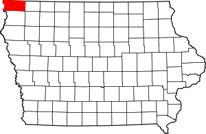
Location of Lyon County in Iowa
This is intended to be a complete list of the properties and districts on the National Register of Historic Places in Lyon County, Iowa, United States. Latitude and longitude coordinates are provided for many National Register properties and districts; these locations may be seen together in a map.[1]
There are 10 properties and districts listed on the National Register in the county, including one National Historic Landmark.
- This National Park Service list is complete through NPS recent listings posted August 14, 2020.[2]
| [3] | Name on the Register[4] | Image | Date listed[5] | Location | City or town | Description |
|---|---|---|---|---|---|---|
| 1 | Big Sioux Prehistoric Prairie Procurement System Archaeological District | January 17, 1989 (#88001169) |
Address Restricted |
Klondike | ||
| 2 | Blood Run Site | 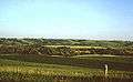 Blood Run Site |
August 29, 1970 (#70000246) |
On the Iowa/South Dakota border along the Big Sioux River[6] 43°30′01″N 96°35′49″W |
Granite | |
| 3 | Broad View Ranch Historic District | September 23, 1994 (#94001137) |
2572 Log Ave. 43°16′33″N 95°54′01″W |
Sheldon | ||
| 4 | Burlington, Cedar Rapids, and Northern Railroad-Rock Rapids Station, Railroad Track and Bridge | 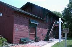 Burlington, Cedar Rapids, and Northern Railroad-Rock Rapids Station, Railroad Track and Bridge |
November 7, 1976 (#76000783) |
N. Story St. 43°26′01″N 96°09′59″W |
Rock Rapids | |
| 5 | Duncan-Duitsman Farm Historic District | September 23, 1994 (#94001138) |
4324 180th St. 43°23′33″N 95°56′04″W |
George | ||
| 6 | First Methodist Church |  First Methodist Church |
June 23, 1978 (#78001244) |
302 S. Carroll St. 43°25′45″N 96°10′19″W |
Rock Rapids | |
| 7 | Klondike Bridge | May 15, 1998 (#98000510) |
180th St. over the Big Sioux River 43°23′16″N 96°31′18″W |
Larchwood | ||
| 8 | Lyon County Courthouse | 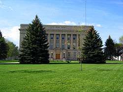 Lyon County Courthouse |
October 1, 1979 (#79000913) |
3rd and Story Sts. 43°25′48″N 96°10′02″W |
Rock Rapids | |
| 9 | Melan Bridge | 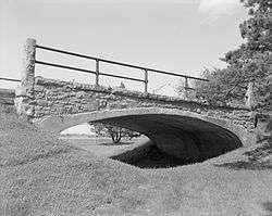 Melan Bridge |
October 18, 1974 (#74000797) |
East of Rock Rapids in Emma Sater Park 43°25′49″N 96°09′19″W |
Rock Rapids | |
| 10 | Charles B. Reynolds Round Barn | July 7, 1999 (#99000737) |
2382 Harrison Ave. 43°18′10″N 96°09′21″W |
Doon | Demolished |
Former listings
| [3] | Name on the Register | Image | Date listed | Date removed | Location | City or town | Summary |
|---|---|---|---|---|---|---|---|
| 1 | Kruger Mill | November 3, 1975 (#75000696) | December 15, 2003 | SW of Larchwood on Sioux River |
Larchwood vicinity |
gollark: I can't really touch IncDec.
gollark: *Or*, with the achievements thing, it gives you points but also adds an achievement which you can't remove showing that you are a cheater.
gollark: I can totally do that.
gollark: I can't really do that, sadly.
gollark: Hmm, *or*, the system™ will expose a function which apparently increments your points, but actually it just gives you fake points which are uncool.
See also
| Wikimedia Commons has media related to National Register of Historic Places in Lyon County, Iowa. |
References
- The latitude and longitude information provided in this table was derived originally from the National Register Information System, which has been found to be fairly accurate for about 99% of listings. Some locations in this table may have been corrected to current GPS standards.
- "National Register of Historic Places: Weekly List Actions". National Park Service, United States Department of the Interior. Retrieved on August 14, 2020.
- Numbers represent an ordering by significant words. Various colorings, defined here, differentiate National Historic Landmarks and historic districts from other NRHP buildings, structures, sites or objects.
- "National Register Information System". National Register of Historic Places. National Park Service. April 24, 2008.
- The eight-digit number below each date is the number assigned to each location in the National Register Information System database, which can be viewed by clicking the number.
- Location derived from this State Historical Society of Iowa website; the NRIS lists it as "Address Restricted"
| Topics | |
|---|---|
| Lists by state |
|
| Lists by insular areas | |
| Lists by associated state | |
| Other areas | |
| Related | |
| |

Municipalities and communities of Lyon County, Iowa, United States | ||
|---|---|---|
| Cities | Map of Iowa highlighting Lyon County | |
| Unincorporated communities | ||
| Ghost town | ||
This article is issued from Wikipedia. The text is licensed under Creative Commons - Attribution - Sharealike. Additional terms may apply for the media files.