National Register of Historic Places listings in Calhoun County, Iowa
This is a list of the National Register of Historic Places listings in Calhoun County, Iowa.
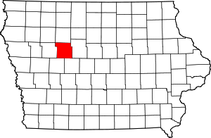
Location of Calhoun County in Iowa
This is intended to be a complete list of the properties and districts on the National Register of Historic Places in Calhoun County, Iowa, United States. Latitude and longitude coordinates are provided for many National Register properties and districts; these locations may be seen together in a map.[1]
There are 12 properties listed on the National Register in the county.
- This National Park Service list is complete through NPS recent listings posted August 14, 2020.[2]
| [3] | Name on the Register[4] | Image | Date listed[5] | Location | City or town | Description |
|---|---|---|---|---|---|---|
| 1 | Calhoun County Courthouse | 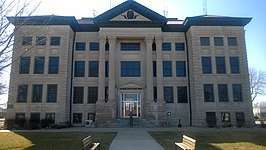 Calhoun County Courthouse |
July 2, 1981 (#81000227) |
Court and 4th Sts. 42°23′41″N 94°38′07″W |
Rockwell City | |
| 2 | Central School | 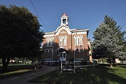 Central School |
January 3, 1985 (#85000001) |
201 S. Center 42°15′57″N 94°44′02″W |
Lake City | |
| 3 | Chicago and North Western Office Building/Passenger Depot-Lake City | 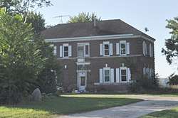 Chicago and North Western Office Building/Passenger Depot-Lake City |
August 27, 1990 (#90001205) |
401 Front St. 42°15′54″N 94°43′46″W |
Lake City | |
| 4 | Perry C. and Mattie Forrest Holdoegel House | May 6, 1992 (#91001831) |
504 8th St. 42°23′39″N 94°38′16″W |
Rockwell City | ||
| 5 | Lake City Community Memorial Building |  Lake City Community Memorial Building |
August 27, 1990 (#90001210) |
118 E. Washington St. 42°16′06″N 94°43′59″W |
Lake City | |
| 6 | Lake City Public Library |  Lake City Public Library |
August 27, 1990 (#90001209) |
120 N. Illinois St. 42°16′06″N 94°43′55″W |
Lake City | The former Carnegie library building. |
| 7 | Lake City Water Standpipe | 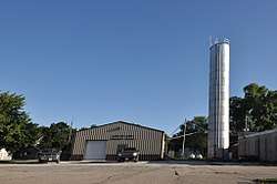 Lake City Water Standpipe |
August 27, 1990 (#90001211) |
100 block of W. Washington St. 42°16′08″N 94°44′03″W |
Lake City | |
| 8 | Marsh Rainbow Arch Bridge | 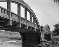 Marsh Rainbow Arch Bridge |
March 30, 1989 (#88002529) |
Highway N37 over the North Raccoon River 42°13′46″N 94°46′03″W |
Lake City | |
| 9 | Rockwell City Bridge | June 25, 1998 (#98000752) |
270th St. over an unnamed stream 42°23′57″N 94°36′25″W |
Rockwell City | ||
| 10 | Smith Farmhouse | 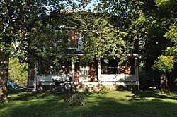 Smith Farmhouse |
August 27, 1990 (#90001206) |
Junction of Rainbow Rd., S. and Monroe St. 42°15′55″N 94°44′46″W |
Lake City | |
| 11 | Gen. Cass and Belle Smith House | 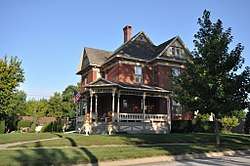 Gen. Cass and Belle Smith House |
August 27, 1990 (#90001207) |
500 W. Main St. 42°16′03″N 94°44′19″W |
Lake City | |
| 12 | Peter and Mary Smith House | 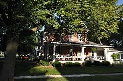 Peter and Mary Smith House |
August 27, 1990 (#90001208) |
304 W. Main St. 42°16′04″N 94°44′11″W |
Lake City |
Former listings
Two properties were once listed on the Register but have since been removed:
| [3] | Name on the Register | Image | Date listed | Date removed | Location | City or town | Summary |
|---|---|---|---|---|---|---|---|
| 1 | Dr. Charles Knapp Round Barn | December 23, 1986 (#86003187) | August 26, 2005 | Off CR D26 |
Jolley | ||
| 2 | Welsh Bridge | June 25, 1998 (#98000751) | December 15, 2003 | 1st Ave. over Welsh's Slough |
Somers | Replaced in 2003 |
gollark: How often will you have a new OS which nobody wrote python for for some reason?
gollark: And going to *vast* amounts of effort to avoid using any higher-level language whatsoever is using tons of your time for bad reasons.
gollark: With a hyperoptimized implementation, which this almost certainly isn't, yes.
gollark: If you can install a C compiler I assume you can also manage to install some sort of python complete enough to run osmarkspythonbuildsystem™.
gollark: The python™ makes it better™.
See also
| Wikimedia Commons has media related to National Register of Historic Places in Calhoun County, Iowa. |
References
- The latitude and longitude information provided in this table was derived originally from the National Register Information System, which has been found to be fairly accurate for about 99% of listings. Some locations in this table may have been corrected to current GPS standards.
- "National Register of Historic Places: Weekly List Actions". National Park Service, United States Department of the Interior. Retrieved on August 14, 2020.
- Numbers represent an ordering by significant words. Various colorings, defined here, differentiate National Historic Landmarks and historic districts from other NRHP buildings, structures, sites or objects.
- "National Register Information System". National Register of Historic Places. National Park Service. April 24, 2008.
- The eight-digit number below each date is the number assigned to each location in the National Register Information System database, which can be viewed by clicking the number.
| Topics | |
|---|---|
| Lists by state |
|
| Lists by insular areas | |
| Lists by associated state | |
| Other areas | |
| Related | |
| |

Municipalities and communities of Calhoun County, Iowa, United States | ||
|---|---|---|
| Cities | Map of Iowa highlighting Calhoun County | |
| Townships | ||
| CDP | ||
| Other unincorporated communities | ||
| Footnotes | ‡This populated place also has portions in an adjacent county or counties | |
This article is issued from Wikipedia. The text is licensed under Creative Commons - Attribution - Sharealike. Additional terms may apply for the media files.