National Register of Historic Places listings in Dickinson County, Iowa
This is a list of the National Register of Historic Places listings in Dickinson County, Iowa.
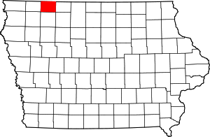
Location of Dickinson County in Iowa
This is intended to be a complete list of the properties and districts on the National Register of Historic Places in Dickinson County, Iowa, United States. Latitude and longitude coordinates are provided for many National Register properties and districts; these locations may be seen together in a map.[1]
There are 12 properties and districts listed on the National Register in the county. Another two properties were once listed on the Register but have since been removed.
- This National Park Service list is complete through NPS recent listings posted August 14, 2020.[2]
Current listings
| [3] | Name on the Register[4] | Image | Date listed[5] | Location | City or town | Description |
|---|---|---|---|---|---|---|
| 1 | Antlers Hotel | 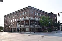 Antlers Hotel |
May 24, 2007 (#07000452) |
1703 Hill Ave. 43°25′30″N 95°06′06″W |
Spirit Lake | |
| 2 | Gerome Clark House |  Gerome Clark House |
November 9, 1977 (#77000510) |
East of Milford 43°19′50″N 95°04′03″W |
Milford | |
| 3 | Gull Point State Park, Area A |  Gull Point State Park, Area A |
November 15, 1990 (#90001661) |
Off Iowa Highway 86 on the western shore of West Okoboji Lake 43°22′16″N 95°10′05″W |
Milford | |
| 4 | Gull Point State Park, Area B | 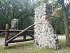 Gull Point State Park, Area B |
November 15, 1990 (#90001662) |
Off Iowa Highway 86 on the western shore of West Okoboji Lake 43°22′22″N 95°09′44″W |
Milford | |
| 5 | Iowa Lakeside Laboratory Historic District | December 23, 1991 (#91001830) |
Iowa Highway 86 about 4 miles north-northwest of its junction with U.S. Route 71 43°22′56″N 95°10′52″W |
Milford | ||
| 6 | Mini-Wakan State Park Historic District | February 17, 2010 (#10000021) |
24490 100th St. 43°30′00″N 95°06′01″W |
Spirit Lake | ||
| 7 | Okoboji Bridge | June 25, 1998 (#98000789) |
180th Ave. over a branch of the Little Sioux River 43°15′39″N 95°13′46″W |
Milford | ||
| 8 | Pikes Point State Park Shelter and Steps | November 15, 1990 (#90001675) |
West of the junction of U.S. Route 71 and Iowa Highway 9 43°24′58″N 95°09′42″W |
Spirit Lake | ||
| 9 | Pillsbury Point State Park | 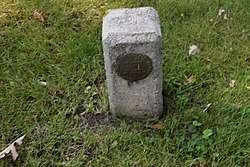 Pillsbury Point State Park |
January 12, 1993 (#90001674) |
Off U.S. Route 71 west of Minnewashta Lake 43°22′04″N 95°08′27″W |
Arnolds Park | |
| 10 | Spirit Lake Massacre Log Cabin | 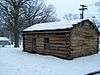 Spirit Lake Massacre Log Cabin |
April 3, 1973 (#73000724) |
West of Estherville on U.S. Route 71 43°22′35″N 95°07′45″W |
Arnolds Park | Abbie Gardner Sharp Cabin at the memorial site operated by the State Historical Society of Iowa. |
| 11 | Spirit Lake Public Library |  Spirit Lake Public Library |
January 24, 1980 (#80001448) |
1801 Hill Ave. 43°25′20″N 95°06′05″W |
Spirit Lake | |
| 12 | Trappers Bay State Park Picnic Shelter | November 15, 1990 (#90001676) |
North of the junction of Iowa Highways 9 and 219 43°27′14″N 95°20′04″W |
Lake Park |
Former listings
| [3] | Name on the Register | Image | Date listed | Date removed | Location | City or town | Summary |
|---|---|---|---|---|---|---|---|
| 1 | Dickinson County Courthouse | 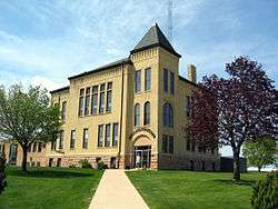 Dickinson County Courthouse |
July 2, 1981 (#81000235) | September 13, 2006 | Hill Avenue |
Spirit Lake | Demolished in 2006 |
| 2 | Templar Park | August 3, 1977 (#77000511) | September 13, 2006 | Northeast of Orleans on Iowa Highway 276 |
Orleans |
gollark: I coined the term cofrex (context-free expression) a while ago, because hydraz..
gollark: Unary minus!
gollark: Yes, yes, whatever.
gollark: It's subtracting a regex from the string, right?
gollark: Like with __add.
See also
| Wikimedia Commons has media related to National Register of Historic Places in Dickinson County, Iowa. |
References
- The latitude and longitude information provided in this table was derived originally from the National Register Information System, which has been found to be fairly accurate for about 99% of listings. Some locations in this table may have been corrected to current GPS standards.
- "National Register of Historic Places: Weekly List Actions". National Park Service, United States Department of the Interior. Retrieved on August 14, 2020.
- Numbers represent an ordering by significant words. Various colorings, defined here, differentiate National Historic Landmarks and historic districts from other NRHP buildings, structures, sites or objects.
- "National Register Information System". National Register of Historic Places. National Park Service. April 24, 2008.
- The eight-digit number below each date is the number assigned to each location in the National Register Information System database, which can be viewed by clicking the number.
| Topics | |
|---|---|
| Lists by state |
|
| Lists by insular areas | |
| Lists by associated state | |
| Other areas | |
| Related | |
| |

Municipalities and communities of Dickinson County, Iowa, United States | ||
|---|---|---|
| Cities | Map of Iowa highlighting Dickinson County | |
| Townships | ||
| Unincorporated community | ||
This article is issued from Wikipedia. The text is licensed under Creative Commons - Attribution - Sharealike. Additional terms may apply for the media files.