Mount-Poonamallee Road
St. Thomas Mount-Poonamallee Road, popularly known as the Mount-Poonamallee Road (SH-55), is an arterial road in the city of Chennai, India. It runs for 11 kilometres from Kathipara Junction to the NH 4 highway connecting St. Thomas Mount with the suburb of Poonamallee. About 5 kilometres of the Mount-Poonamallee Road is located in the Alandur taluk of Chennai district, part of Maduravoyal Taluk in Chennai district and the remainder in the Poonamallee taluk of Thiruvallur district.
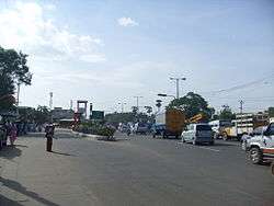
Manapakkam signal on Mount-Poonamallee Road
Features
The road is divided into two sections. The first section from St. Thomas Mount to Nandambakkam covering a distance of one kilometre is more narrow than the rest of the stretch and is known as Butt Road.

Dr. M. G. R. Home and Higher Secondary School for the Speech and Hearing Impaired, Ramapuram MGR Gardens, Manapakkam
Places transversed
- St. Thomas Mount
- Nandambakkam
- Ramapuram
- Manapakkam
- Mugalivakkam
- Porur
- Iyyappanthangal
- Kattupakkam
- Karayanchavadi
- Kumananchavadi
- Poonamallee
gollark: *It* can just symlink a folder or something.
gollark: I doubt it.
gollark: No, syncing to an ingame computer or something.
gollark: Is there good software for this?
gollark: I would actually really like automated CC syncing to a folder on my computer or something.
See also
References
- "Mount-Poonamallee Road getting facelift". The Hindu. 18 December 2008.
| Companies and organisations |
| ||||||||||
|---|---|---|---|---|---|---|---|---|---|---|---|
| Airports |
| ||||||||||
| Rail Transport |
| ||||||||||
| Roads |
| ||||||||||
| Water/Sea Transport |
| ||||||||||
| |||||||||||
This article is issued from Wikipedia. The text is licensed under Creative Commons - Attribution - Sharealike. Additional terms may apply for the media files.