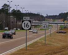
Mississippi Highway 16
Mississippi Highway 16 (MS 16) is a state highway in Mississippi. It runs for 166.472 miles (267.911 km) and serves 8 counties: Issaquena, Sharkey, Yazoo, Humphreys, Madison, Leake, Neshoba, and Kemper.
| ||||
|---|---|---|---|---|
| Route information | ||||
| Maintained by MDOT | ||||
| Length | 166.472 mi[1] (267.911 km) | |||
| Major junctions | ||||
| West end | ||||
| ||||
| East end | ||||
| Location | ||||
| Counties | Issaquena, Sharkey, Yazoo, Humphreys, Madison, Leake, Neshoba, Kemper | |||
| Highway system | ||||
| ||||
Locales on Route
From West to East
- Grace
- Rolling Fork
- Canton
- Carthage
- Pearl River
- Philadelphia
- De Kalb
- Scooba
Major intersections
| County | Location | mi | km | Destinations | Notes | ||
|---|---|---|---|---|---|---|---|
| Issaquena | Grace | Grace Road | Western terminus; to MS 1 | ||||
| Sharkey | Rolling Fork | Rosenwald Avenue | East end of state maintenance | ||||
| Gap in route | |||||||
| Yazoo | Holly Bluff | Sartaria Road - Lake George Wildlife Management Area | To MS 433 | ||||
| | West end of MS 149 overlap | ||||||
| Yazoo City | interchange | ||||||
| East end of MS 149 overlap; west end of US 49 overlap | |||||||
| | East end of US 49 overlap | ||||||
| | |||||||
| Madison | | I-55 exit 124 | |||||
| Canton | West end of US 51 overlap | ||||||
| Eastern terminus of MS 22 | |||||||
| East end of US 51 overlap | |||||||
| West end of MS 43 overlap | |||||||
| East end of MS 43 overlap | |||||||
| | Southern terminus of MS 17 | ||||||
| Leake | | Natchez Trace | Interchange | ||||
| Wiggins | Interchange | ||||||
| Carthage | |||||||
| Edinburg | Northern terminus of MS 427 | ||||||
| Neshoba | Philadelphia | West end of MS 15 / MS 21 overlap | |||||
| Cooper Williams Drive - Williamsville | |||||||
| East end of MS 15 overlap; west end of MS 19 overlap | |||||||
| East end of MS 21 overlap | |||||||
| East end of MS 19 overlap | |||||||
| Williamson Avenue | Proposed MS 894 | ||||||
| | Western terminus of MS 482 | ||||||
| | Road 547 | Proposed MS 853 | |||||
| Crossroads | Southern terminus of MS 491 | ||||||
| Kemper | | West end of MS 495 overlap | |||||
| | East end of MS 495 overlap | ||||||
| | Joe W. Williams Field | Proposed MS 493 north | |||||
| | Northern terminus of MS 493 | ||||||
| | Southern terminus of MS 397 | ||||||
| De Kalb | |||||||
| Scooba | |||||||
| | Eastern terminus | ||||||
1.000 mi = 1.609 km; 1.000 km = 0.621 mi
| |||||||
gollark: It's probably using virtual filesystem tricks like potatOS.
gollark: Oh no. This could have substantial effects on my IndexedDB-based website achievement system.
gollark: I doubt anyone actually uses native C# types for this so who knows really.
gollark: It doesn't really need high precision, but does need many, many numbers in as little memory as possible.
gollark: I did say why you might want that.
References
- "Mississippi Public Roads Selected Statistics" (PDF). Mississippi Department of Transportation. 2008. Archived from the original (PDF) on 2010-12-03. Retrieved 2010-06-03.
External links
![]()
This article is issued from Wikipedia. The text is licensed under Creative Commons - Attribution - Sharealike. Additional terms may apply for the media files.

