Mississippi Highway 1
Mississippi Highway 1 (MS 1) runs south from U.S. Highway 49 near Lula to U.S. Highway 61 south of Cary, roughly paralleling the Mississippi River. It travels approximately 148 miles (238 km), serving Sharkey, Issaquena, Washington, Bolivar, and Coahoma Counties. The entire route is part of the Great River Road.
| ||||
|---|---|---|---|---|
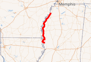
MS 1 highlighted in red | ||||
| Route information | ||||
| Maintained by MDOT | ||||
| Length | 148.632 mi[1] (239.200 km) | |||
| Major junctions | ||||
| South end | ||||
| North end | ||||
| Location | ||||
| Counties | Coahoma, Bolivar, Washington, Issaquena, Sharkey | |||
| Highway system | ||||
| ||||

Major intersections
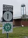
Mississippi 1 departs US 49
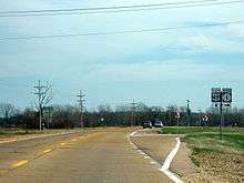
Benoit water tower seen from Mississippi Highway 1
| County | Location | mi[2] | km | Destinations | Notes |
|---|---|---|---|---|---|
| Sharkey | Onward | 0.0 | 0.0 | Southern terminus | |
| Issaquena | | 4.7 | 7.6 | Northern terminus of MS 465 | |
| Mayersville | 22.9 | 36.9 | South end of MS 14 overlap | ||
| | 28.6 | 46.0 | North end of MS 14 overlap | ||
| Grace | 34.2 | 55.0 | Grace Road | To MS 16 | |
| Washington | Hampton | 37.8 | 60.8 | ||
| | 48.7 | 78.4 | Western terminus of MS 12 | ||
| Wayside | 55.7 | 89.6 | Western terminus of MS 438 | ||
| | 58.9 | 94.8 | Eastern terminus of MS 454 | ||
| | Greenville Bypass under construction | ||||
| Greenville | 63.8 | 102.7 | Reed Road | proposed MS 814 | |
| 64.8 | 104.3 | ||||
| 67.5 | 108.6 | Broadway (MS 814 west) – Metcalfe, Casinos, Mid-Delta Regional Airport | Eastern terminus of MS 814 | ||
| Bolivar | | 77.8 | 125.2 | Western terminus of MS 450 | |
| Benoit | 84.9 | 136.6 | Western terminus of MS 448 | ||
| | 89.0 | 143.2 | Western terminus of MS 446 | ||
| Rosedale | 100.0 | 160.9 | Western terminus of MS 8 | ||
| | 107.6 | 173.2 | Western terminus of MS 804 | ||
| Gunnison | 108.5 | 174.6 | Eastern terminus of MS 804 | ||
| | 110.7 | 178.2 | Western terminus of MS 32 | ||
| | 117.8 | 189.6 | Western terminus of MS 444 | ||
| Coahoma | Sherard | 132.7 | 213.6 | Western terminus of MS 322 | |
| | 145.1 | 233.5 | Friars Point, North Delta Museum | proposed MS 316 | |
| | 154.3 | 248.3 | Northern terminus | ||
1.000 mi = 1.609 km; 1.000 km = 0.621 mi
| |||||
gollark: Should you be committing a DB to the repo?
gollark: I'm not really that good *either*, but I can look for... obvious issues of some sort.
gollark: I guess so.
gollark: Kind of.
gollark: Simply block SolarFlame5.
References
- Mississippi Department of Transportation Planning Division (December 31, 2013). Mississippi Public Roads Selected Statistics Extent, Travel, and Designation (PDF) (Report). Mississippi Department of Transportation. p. 151. Archived from the original (PDF) on December 7, 2014. Retrieved December 22, 2014.
- Google (December 22, 2014). "Mississippi Highway 1" (Map). Google Maps. Google. Retrieved December 22, 2014.
External links
![]()
This article is issued from Wikipedia. The text is licensed under Creative Commons - Attribution - Sharealike. Additional terms may apply for the media files.