Mississippi Highway 3
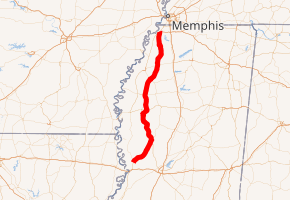
Mississippi Highway 3 (MS 3) runs north–south from Newport to U.S. Route 49W near Inverness. For part of its duration, MS 3 is a concurrency with US 49 West. It travels approximately 119 miles (192 km), serving DeSoto, Tunica, Tate, Panola, Quitman, Tallahatchie, Sunflower, Yazoo, and Warren counties.
| ||||
|---|---|---|---|---|

MS 3 highlighted in red | ||||
| Route information | ||||
| Maintained by MDOT | ||||
| Length | 119.401 mi[1] (192.157 km) | |||
| Major junctions | ||||
| South end | ||||
| North end | ||||
| Location | ||||
| Counties | DeSoto, Tunica, Tate, Panola, Quitman, Tallahatchie, Sunflower, Yazoo, Warren | |||
| Highway system | ||||
| ||||
Locales on route
From north to south
Major intersections
| County | Location | mi | km | Destinations | Notes | ||
|---|---|---|---|---|---|---|---|
| Warren | Redwood | Interchange; southern terminus | |||||
| Yazoo | | ||||||
| Yazoo City | Interchange | ||||||
| Interchange; south end of US 49W overlap | |||||||
| Overlap with US 49W | |||||||
| Sunflower | | North end of US 49W overlap | |||||
| | |||||||
| | South end of US 49W overlap | ||||||
| Overlap with US 49W | |||||||
| Tallahatchie | Tutwiler | North end of US 49W overlap; south end of US 49 overlap; US 49W north and US 49E merge into US 49 | |||||
| North end of US 49 overlap | |||||||
| Quitman | | South end of MS 322 overlap | |||||
| Lambert | North end of MS 322 overlap | ||||||
| Marks | |||||||
| Sledge | Eastern terminus of MS 714 | ||||||
| Panola | Crenshaw | Western terminus of MS 310 | |||||
| Tate | | South end of MS 4 overlap | |||||
| Tunica | | North end of MS 4 overlap | |||||
| Banks | |||||||
| DeSoto | | Interchange; no access to westbound MS 304 | |||||
| | Northern terminus | ||||||
1.000 mi = 1.609 km; 1.000 km = 0.621 mi
| |||||||
gollark: It's a shame we have not reached the cool™ point where whiteboards can trivially and cheaply be computers or something, so you can subtly erase unwanted parts remotely.
gollark: There must be some way to erase whiteboards remotely.
gollark: Erase it.
gollark: That sure does rapidly print Stop and some errors.
gollark: Or just get good and encode/decode TLS by hand.
See also
![]()
![]()
References
- "Mississippi Public Roads Selected Statistics" (PDF). Mississippi Department of Transportation. 2008. Archived from the original (PDF) on 2010-12-03. Retrieved 2010-06-03.
This article is issued from Wikipedia. The text is licensed under Creative Commons - Attribution - Sharealike. Additional terms may apply for the media files.
