Minversheim
Minversheim is a commune in the Bas-Rhin department and Grand Est region of north-eastern France.
Minversheim Memfersche | |
|---|---|
 A general view of Minversheim | |
 Coat of arms | |
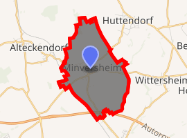
Location of Minversheim 
| |
 Minversheim  Minversheim | |
| Coordinates: 48°47′09″N 7°37′23″E | |
| Country | France |
| Region | Grand Est |
| Department | Bas-Rhin |
| Arrondissement | Saverne |
| Canton | Bouxwiller |
| Intercommunality | CC Pays de la Zorn |
| Government | |
| • Mayor (2014–2020) | Bernard Lienhard |
| Area 1 | 5.45 km2 (2.10 sq mi) |
| Population (2017-01-01)[1] | 661 |
| • Density | 120/km2 (310/sq mi) |
| Time zone | UTC+01:00 (CET) |
| • Summer (DST) | UTC+02:00 (CEST) |
| INSEE/Postal code | 67293 /67270 |
| Elevation | 157–258 m (515–846 ft) |
| 1 French Land Register data, which excludes lakes, ponds, glaciers > 1 km2 (0.386 sq mi or 247 acres) and river estuaries. | |
Population
| Year | Pop. | ±% |
|---|---|---|
| 1946 | 588 | — |
| 1954 | 534 | −9.2% |
| 1962 | 545 | +2.1% |
| 1968 | 539 | −1.1% |
| 1975 | 541 | +0.4% |
| 1982 | 501 | −7.4% |
| 1990 | 485 | −3.2% |
| 1999 | 510 | +5.2% |
| 2007 | 620 | +21.6% |
| 2017 | 661 | +6.6% |
gollark: I think it's a Permissions problem.
gollark: @SolarFlame5
gollark: Wait... it doesn't say to hash the *previous* whole string...
gollark: Who thought, though "hash it 18 times, that's a great idea"?
gollark: But... but why?
See also
References
- "Populations légales 2017". INSEE. Retrieved 6 January 2020.
| Wikimedia Commons has media related to Minversheim. |
This article is issued from Wikipedia. The text is licensed under Creative Commons - Attribution - Sharealike. Additional terms may apply for the media files.