Kogenheim
Kogenheim is a commune in the Bas-Rhin department in Grand Est in north-eastern France.
Kogenheim Koiene | |
|---|---|
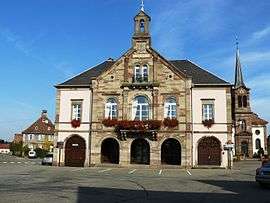 The town hall in Kogenheim | |
 Coat of arms | |
Location of Kogenheim 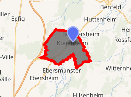
| |
 Kogenheim  Kogenheim | |
| Coordinates: 48°20′17″N 7°32′32″E | |
| Country | France |
| Region | Grand Est |
| Department | Bas-Rhin |
| Arrondissement | Sélestat-Erstein |
| Canton | Erstein |
| Intercommunality | Benfeld et environs |
| Government | |
| • Mayor (2014–2020) | Francine Froment |
| Area 1 | 11.77 km2 (4.54 sq mi) |
| Population (2017-01-01)[1] | 1,265 |
| • Density | 110/km2 (280/sq mi) |
| Time zone | UTC+01:00 (CET) |
| • Summer (DST) | UTC+02:00 (CEST) |
| INSEE/Postal code | 67246 /67230 |
| Elevation | 159–166 m (522–545 ft) |
| 1 French Land Register data, which excludes lakes, ponds, glaciers > 1 km2 (0.386 sq mi or 247 acres) and river estuaries. | |
Geography
The commune is on the east of the Route Nationale RN83, till recently the main road linking Strasbourg with Colmar and still, despite extensive official 'declassification' following the opening of the Autoroute A35 a short distance to the west, a major regional road artery. Kogenheim also has its own railway station.
gollark: I hope you're implementing actions in a way I agree with.
gollark: You CAN just ask me how it works.
gollark: Anyway, on the plus side, I have great features now.
gollark: Why?
gollark: I'm tempted to replace (AIO)SQLite and my custom connection pool with 73728929394 dicts in memory.
See also
References
- "Populations légales 2017". INSEE. Retrieved 6 January 2020.
| Wikimedia Commons has media related to Kogenheim. |
| Authority control |
|
|---|
This article is issued from Wikipedia. The text is licensed under Creative Commons - Attribution - Sharealike. Additional terms may apply for the media files.