Kilstett
Kilstett is a commune in the Bas-Rhin department in Grand Est in north-eastern France.
Kilstett | |
|---|---|
 The town hall in Kilstett | |
.svg.png) Coat of arms | |
Location of Kilstett 
| |
 Kilstett  Kilstett | |
| Coordinates: 48°40′35″N 7°51′24″E | |
| Country | France |
| Region | Grand Est |
| Department | Bas-Rhin |
| Arrondissement | Haguenau-Wissembourg |
| Canton | Brumath |
| Government | |
| • Mayor (2001–2008) | Gabriel Muller |
| Area 1 | 6.90 km2 (2.66 sq mi) |
| Population (2017-01-01)[1] | 2,510 |
| • Density | 360/km2 (940/sq mi) |
| Time zone | UTC+01:00 (CET) |
| • Summer (DST) | UTC+02:00 (CEST) |
| INSEE/Postal code | 67237 /67840 |
| Elevation | 126–131 m (413–430 ft) |
| 1 French Land Register data, which excludes lakes, ponds, glaciers > 1 km2 (0.386 sq mi or 247 acres) and river estuaries. | |
Its inhabitants are known as Kilstettois.
Geography
Kilstett is positioned about fifteen kilometres (nine miles) to the north of Strasbourg.
It has its own stop on the little railway line that connects Strasbourg with the German frontier town of Lauterbourg, and is approximately three kilometres (two miles) to the east of Junction 50 on the Autoroute A35, which is the principal north-south highway in Alsace.
Infrastructures and shops
Kilstett has a match shop, bakeries, a Crédit Mutuel bank and a pub called A l'Arbre Vert.
History

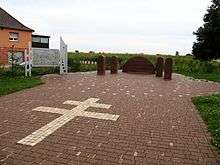
Battle of Kilstett memorial
In January 1945, a German counter-offensive intended to reconquer Strasbourg was stopped at the Battle of Kilstett.
gollark: Idea: palaiologoscoin™ blockchain™.
gollark: Nope, none are safe.
gollark: Nothing in the code actually uses it apart from the ECC library, but it's there.
gollark: Interesting fact: PotatOS actually ships its own secure RNG for cryptographic purposes.
gollark: It takes me something like 10 seconds to publish code I write in random-stuff and no effort to not do that.
See also
References
- "Populations légales 2017". INSEE. Retrieved 6 January 2020.
| Wikimedia Commons has media related to Kilstett. |
This article is issued from Wikipedia. The text is licensed under Creative Commons - Attribution - Sharealike. Additional terms may apply for the media files.