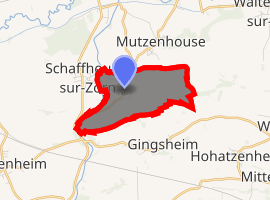
Hohfrankenheim
Hohfrankenheim is a commune in the Bas-Rhin department in Grand Est in north-eastern France.
Hohfrankenheim Huhfrànkne | |
|---|---|
The Protestant church in Hohfrankenheim | |
.svg.png) Coat of arms | |
Location of Hohfrankenheim 
| |
 Hohfrankenheim  Hohfrankenheim | |
| Coordinates: 48°43′51″N 7°34′38″E | |
| Country | France |
| Region | Grand Est |
| Department | Bas-Rhin |
| Arrondissement | Saverne |
| Canton | Bouxwiller |
| Government | |
| • Mayor (2001–2008) | Richard Hornecker |
| Area 1 | 2.76 km2 (1.07 sq mi) |
| Population (2017-01-01)[1] | 265 |
| • Density | 96/km2 (250/sq mi) |
| Time zone | UTC+01:00 (CET) |
| • Summer (DST) | UTC+02:00 (CEST) |
| INSEE/Postal code | 67209 /67270 |
| Elevation | 168–260 m (551–853 ft) |
| 1 French Land Register data, which excludes lakes, ponds, glaciers > 1 km2 (0.386 sq mi or 247 acres) and river estuaries. | |
History
The first surviving record of Hohfrankenheim dates from 830.
gollark: apioforms.osmarks.net
gollark: Also, are you offering subdomains of that?
gollark: Do so immediately. You have 483fs.
gollark: VideoEnhance is just denoising or scaling or something and nothing uses it, Blit is ???.
gollark: I have never actually seen Blit or VideoEnhance get used.
See also
References
- "Populations légales 2017". INSEE. Retrieved 6 January 2020.
| Wikimedia Commons has media related to Hohfrankenheim. |
This article is issued from Wikipedia. The text is licensed under Creative Commons - Attribution - Sharealike. Additional terms may apply for the media files.