Mennecy
Mennecy is a commune in the Essonne department in Île-de-France in northern France.
Mennecy | |
|---|---|
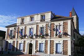 The town hall in Mennecy | |
.svg.png) Coat of arms | |
Location of Mennecy 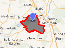
| |
 Mennecy  Mennecy | |
| Coordinates: 48°33′58″N 2°26′13″E | |
| Country | France |
| Region | Île-de-France |
| Department | Essonne |
| Arrondissement | Évry |
| Canton | Mennecy |
| Intercommunality | Val d'Essonne |
| Government | |
| • Mayor (2014–2017) | Sebastiano Visentin |
| Area 1 | 11.09 km2 (4.28 sq mi) |
| Population (2017-01-01)[1] | 14,319 |
| • Density | 1,300/km2 (3,300/sq mi) |
| Time zone | UTC+01:00 (CET) |
| • Summer (DST) | UTC+02:00 (CEST) |
| INSEE/Postal code | 91386 /91540 |
| Elevation | 42–97 m (138–318 ft) |
| 1 French Land Register data, which excludes lakes, ponds, glaciers > 1 km2 (0.386 sq mi or 247 acres) and river estuaries. | |
It is 33km south-east of Paris and crossed by the Essonne river. Inhabitants of Mennecy are known as Menneçois.
Geography
Mennecy is 33 kilometers south east of Paris-Notre-Dame, point zero from roads of France, 8 kilometers south of Évry, 6 kilometers south west of Corbeil-Essonnes, 11 kilometers north east of La Ferté-Alais, 14 kilometers east of Arpajon, 15 kilometers south east of Montlhéry, 19 kilometers north of Milly-la-Forêt, 22 kilometers south east of Palaiseau, 25 kilometers north east of Étampes, 31 kilometers north east of Dourdan.
Twin towns
Mennecy is twinned with the villages Countesthorpe in Leicestershire, United Kingdom, Occhiobello in Italy and Renningen in Baden-Württemberg, Germany.
See also
References
- INSEE
- Mayors of Essonne Association (in French)
- "Populations légales 2017". INSEE. Retrieved 6 January 2020.
External links
| Wikimedia Commons has media related to Mennecy. |
- Official website (in French)
- Official blog (in French)
- Mérimée database - Cultural heritage (in French)
- Land use (IAURIF) (in English)
| Authority control |
|
|---|