Breuillet, Essonne
Breuillet (French: [bʁøjɛ] (![]()
Breuillet | |
|---|---|
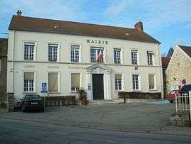 The town hall of Breuillet | |
.svg.png) Coat of arms | |
Location of Breuillet 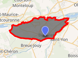
| |
 Breuillet  Breuillet | |
| Coordinates: 48°33′57″N 2°10′14″E | |
| Country | France |
| Region | Île-de-France |
| Department | Essonne |
| Arrondissement | Palaiseau |
| Canton | Dourdan |
| Intercommunality | CA Cœur d'Essonne |
| Government | |
| • Mayor (2008–2014) | Bernard Sprotti (PR) |
| Area 1 | 6.69 km2 (2.58 sq mi) |
| Population (2017-01-01)[1] | 8,394 |
| • Density | 1,300/km2 (3,200/sq mi) |
| Time zone | UTC+01:00 (CET) |
| • Summer (DST) | UTC+02:00 (CEST) |
| INSEE/Postal code | 91105 /91650 |
| Elevation | 50–116 m (164–381 ft) |
| 1 French Land Register data, which excludes lakes, ponds, glaciers > 1 km2 (0.386 sq mi or 247 acres) and river estuaries. | |
It is located between Arpajon and Dourdan.
Inhabitants of Breuillet are known as Breuilletois.
Twin towns
Breuillet has town twinning and cooperation agreement with:
gollark: 100GB/s or so.
gollark: Did you know that GNU Yes can print `y\n` at 3GB/s, which is something like 5% of the maximum achieved `y\n` printing speed?
gollark: On the plus side, GNU Yes is quite good.
gollark: (especially since a lot of software will now just do "0" or "some random number not corresponding to the error")
gollark: Also, exit codes are quite bee.
See also
References
- Mayors of Essonne Association (in French)
- "Populations légales 2017". INSEE. Retrieved 6 January 2020.
External links
| Wikimedia Commons has media related to Breuillet (Essonne). |
- Official website (in French)
- Mérimée database - Cultural heritage (in French)
- Land use (IAURIF) (in English)
| Authority control |
|
|---|
This article is issued from Wikipedia. The text is licensed under Creative Commons - Attribution - Sharealike. Additional terms may apply for the media files.