Courson-Monteloup
Courson-Monteloup (French: [kuʁsɔ̃.mɔ̃tlu] (![]()
Courson-Monteloup | |
|---|---|
 The town hall of Courson-Monteloup | |
 Coat of arms | |
Location of Courson-Monteloup 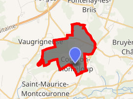
| |
 Courson-Monteloup  Courson-Monteloup | |
| Coordinates: 48°35′35″N 2°08′42″E | |
| Country | France |
| Region | Île-de-France |
| Department | Essonne |
| Arrondissement | Palaiseau |
| Canton | Dourdan |
| Intercommunality | Pays de Limours |
| Government | |
| • Mayor (2008–2014) | Alain Artoré |
| Area 1 | 3.74 km2 (1.44 sq mi) |
| Population (2017-01-01)[1] | 572 |
| • Density | 150/km2 (400/sq mi) |
| Time zone | UTC+01:00 (CET) |
| • Summer (DST) | UTC+02:00 (CEST) |
| INSEE/Postal code | 91186 /91680 |
| Elevation | 72–104 m (236–341 ft) |
| 1 French Land Register data, which excludes lakes, ponds, glaciers > 1 km2 (0.386 sq mi or 247 acres) and river estuaries. | |
Residents
Inhabitants of Courson-Monteloup are known as Montelupins.
gollark: Well, it looks like malloc is erroring. osmarksmalloc™ literally cannot fail.
gollark: Use osmarksmalloc™ instead?
gollark: Yes. Via very long-running MitM attacks on your internet connection, I actually replaced all the language documentation you viewed with docs for different Forth dialects.
gollark: Same syntax, even. How creative.
gollark: It does, yes.
See also
References
- INSEE
- Mayors of Essonne Association (in French)
- "Populations légales 2017". INSEE. Retrieved 6 January 2020.
External links
| Wikimedia Commons has media related to Courson-Monteloup. |
- Mérimée database - Cultural heritage (in French)
- Land use (IAURIF) (in English)
| Authority control |
|
|---|
This article is issued from Wikipedia. The text is licensed under Creative Commons - Attribution - Sharealike. Additional terms may apply for the media files.