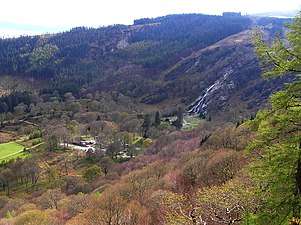
Maulin
Maulin (Irish: Málainn, meaning "High or sloping ground")[2] at 570 metres (1,870 ft), is the 272nd–highest peak in Ireland on the Arderin scale,[3] however, being below 600 m it does not rank on the Vandeleur-Lynam or Hewitt scales.[4][5] Maulin is in the far northeastern section of the Wicklow Mountains, at the mouth of Glensoulan Valley; Powerscourt Waterfall lies at its base.[6][7]
| Maulin | |
|---|---|
| Málainn | |
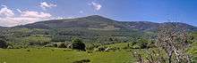
.jpg) Maulin summit viewed from Tonduff | |
| Highest point | |
| Elevation | 570 m (1,870 ft) [1] |
| Prominence | 70 m (230 ft) [1] |
| Listing | Arderin |
| Coordinates | 53°09′22″N 6°13′50″W |
| Naming | |
| English translation | High or sloping ground |
| Language of name | Irish |
| Pronunciation | Irish: [ˈmˠaːɫ̪ən̠ʲ ] |
| Geography | |
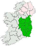
 Maulin Location in Ireland | |
| Location | Wicklow, Republic of Ireland |
| Parent range | Wicklow Mountains |
| OSI/OSNI grid | O184131 |
| Topo map | OSi Discovery 56 |
| Geology | |
| Mountain type | Dark blue-grey slate, phyllite & schist[1] |
| Climbing | |
| Easiest route | from Crone Woods |
Maulin is accessed from the trails through Crone Woods, a Sitka spruce plantation on its northern slopes; Maulin is also accessible just off the main Wicklow Way.[8] Maulin is often climbed as part of a "loop route" called the Circuit of Glensoulan which starts at Crone Woods car-park, and complete a 16-kilometre loop of Maulin, Tonduff 642 metres (2,106 ft), War Hill 686 metres (2,251 ft), and Djouce 725 metres (2,379 ft), and then returning to Crone Woods car-park.[9][7]
The Knockree An Óige youth hostel is located at the base of Maulin in Lackandarragh near the village of Enniskerry.[7]
Bibliography
- Fairbairn, Helen (2014). Dublin & Wicklow: A Walking Guide. Collins Press. ISBN 978-1848892019.
- MountainViews Online Database (Simon Stewart) (2013). A Guide to Ireland's Mountain Summits: The Vandeleur-Lynams & the Arderins. Collins Books. ISBN 978-1-84889-164-7.
- Dillion, Paddy (1993). The Mountains of Ireland: A Guide to Walking the Summits. Cicerone. ISBN 978-1852841102.
See also
| Wikimedia Commons has media related to Maulin. |
References
- "Maulin". MountainViews Online Database. Retrieved 11 July 2019.
- Paul Tempan (February 2012). "Irish Hill and Mountain Names" (PDF). MountainViews.ie.
- Simon Stewart (October 2018). "Arderins: Irish mountains of 500+m with a prominence of 30m". MountainViews Online Database.
- Simon Stewart (October 2018). "Vandeleur-Lynams: Irish mountains of 600+m with a prominence of 15m". MountainViews Online Database.
- Mountainviews, (September 2013), "A Guide to Ireland's Mountain Summits: The Vandeleur-Lynams & the Arderins", Collins Books, Cork, ISBN 978-1-84889-164-7
- Simon Stewart (2018). "Arderins + Arderin Begs: Irish mountains of 500+m with a prominence of 15+m". MountainViews.
Listing selection: All summits (531) in list Arderins + Arderin Begs
- Dillion, Paddy (1993). The Mountains of Ireland: A Guide to Walking the Summits. Cicerone. ISBN 978-1852841102.
Walk 2: Tonduff and Kippure
- Fairbairn, Helen (2014). Dublin & Wicklow: A Walking Guide. Collins Press. ISBN 978-1848892019.
Route 11: The Maulin Circuit
- Michael Guilfoyle (11 November 2015). "A walk for the weekend: Circuit of Glensoulan, Co Wicklow". Irish Times. Retrieved 10 July 2019.
| British Isles |  | |
|---|---|---|
| Scotland | ||
| Outside Scotland | ||
| England | ||
| Ireland | ||
| County tops | ||
.jpg)
External links
- MountainViews: The Irish Mountain Website, Maulin
- MountainViews: Irish Online Mountain Database
- The Database of British and Irish Hills , the largest database of British Isles mountains ("DoBIH")
- Hill Bagging UK & Ireland, the searchable interface for the DoBIH