Annagh Hill
Annagh Hill (An tEannach) meaning marsh or bog in Gaelic. Located in the north of county Wexford.
| Annagh Hill | |
|---|---|
| An tEannach Meaning Marsh or Bog | |
 Annagh Hill, from the southeast | |
| Highest point | |
| Elevation | 454 m (1,490 ft) [1] |
| Prominence | 231 m (758 ft) [1] |
| Listing | Marilyn |
| Coordinates | 52°45′N 6°22′W |
| Geography | |
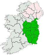
 Annagh Hill Location in Ireland | |
| Location | Wexford, Ireland |
| Parent range | Wicklow Mountains |
| OSI/OSNI grid | T100680 |
| Topo map | OSi Discovery 62 |
Geography
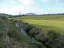
Bann River and Annagh Hill
Annagh Hill is separated from Croghan Mountain to the north by the "Wicklow Gap", not to be confused with the Wicklow Gap in County Wicklow. Except for the southeastern face (see photo) it is covered in coniferous forestry.
It overlooks the villages of Monaseed and Hollyfort to the south, across the valley of the Blackwater stream
gollark: Just make your own CPUs in your basement.
gollark: Specifically "the service provider has access to my messages, unencrypted", rather than "what if all consumer computing hardware has backdoors I can't fix".
gollark: Not really, you can defend fine against the actually-realistic-and-problematic-for-you issues.
gollark: It's not ideal.
gollark: And AMD has the platform security processor.
References
- "Dublin/Wicklow Area - Annagh Hill". MountainViews. Ordnance Survey Ireland. Retrieved 30 June 2015.
![]()
See also
- River Bann (Wexford)
This article is issued from Wikipedia. The text is licensed under Creative Commons - Attribution - Sharealike. Additional terms may apply for the media files.