Maroochy River, Queensland
Maroochy River is a hinterland locality in the Sunshine Coast Region, Queensland, Australia.[1]
| Maroochy River Queensland | |||||||||||||||
|---|---|---|---|---|---|---|---|---|---|---|---|---|---|---|---|
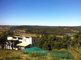 View from slopes of Mount Ninderry towards the Maroochy River, 2012 | |||||||||||||||
 Maroochy River | |||||||||||||||
| Coordinates | 26°34′54″S 153°01′04″E | ||||||||||||||
| Postcode(s) | 4561 | ||||||||||||||
| Location | 113 km (70 mi) N of Brisbane | ||||||||||||||
| LGA(s) | Sunshine Coast Region | ||||||||||||||
| State electorate(s) | Ninderry | ||||||||||||||
| Federal Division(s) | Fairfax | ||||||||||||||
| |||||||||||||||
Geography
The Maroochy River meanders from west to east through the locality. The surrounding river flats are cleared and primarily used for farming. The hillsides in the north-west and south-east of the locality are primarily used for residential purposes and retain natural bushland. Coolum Creek forms the eastern boundary of the locality.[2]
History
In the 2011 census Maroochy River had a population of 1,337 people.[3]
Heritage listings
River barge transporting rakes of cut sugar cane at Dunethin Rock, 1920s
Maroochy River has a number of heritage-listed sites, including:
- Dunethin Rock Road: Dunethin Rock[4]
- Store Road: Tramway Lift Bridge over Maroochy River[5]
gollark: Reposts are NOT REAL and DO NOT EXIST.
gollark: Correction: the sharks represent bees and must be feared.
gollark: No, the sharks are IPv4, as it's actually bad.
gollark: I don't have headphones plugged in.
gollark: Oh, right, sound exists.
References
- "Maroochy River (entry 49435)". Queensland Place Names. Queensland Government. Retrieved 25 July 2015.
- "Queensland Globe". State of Queensland. Retrieved 25 July 2015.
- Australian Bureau of Statistics (31 October 2012). "Maroochy River". 2011 Census QuickStats. Retrieved 25 July 2015.

- "Dunethin Rock (entry 602695)". Queensland Heritage Register. Queensland Heritage Council. Retrieved 14 July 2013.
- "Tramway Lift Bridge over Maroochy River (entry 602527)". Queensland Heritage Register. Queensland Heritage Council. Retrieved 14 July 2013.
External links
![]()
This article is issued from Wikipedia. The text is licensed under Creative Commons - Attribution - Sharealike. Additional terms may apply for the media files.