Wootha, Queensland
Wootha is a locality in the Sunshine Coast Region, Queensland, Australia.[1]
| Wootha Queensland | |||||||||||||||
|---|---|---|---|---|---|---|---|---|---|---|---|---|---|---|---|
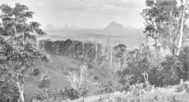
 Looking across Wootha towards the Glass House Mountains, circa 1931 | |||||||||||||||
 Wootha | |||||||||||||||
| Coordinates | 26.7875°S 152.8002°E | ||||||||||||||
| Postcode(s) | 4552 | ||||||||||||||
| Area | 18.1 km2 (7.0 sq mi) | ||||||||||||||
| LGA(s) | Sunshine Coast Region | ||||||||||||||
| State electorate(s) | Glass House | ||||||||||||||
| Federal Division(s) | Fisher | ||||||||||||||
| |||||||||||||||
History
The name Wootha comes from the Kabi language (Dallambara dialect) meaning red cedar tree.[1]
Blackall Range Provisional School opened about 1886, becoming Blackall Range State School on 1 October 1909. It was renamed Wootha State School in 1937. It closed in 1949.[2]
gollark: Also, this is very very longwinded.
gollark: I don't agree with those lines, actually.
gollark: Again, I don't see how this is a necessary component of libertarian ideologies.
gollark: You could probably argue for this, but I don't think this follows at all from a libertarian rights-based philosophy.
gollark: What is the "original Position"?
References
- "Wootha - locality in Sunshine Coast Region (entry 48944)". Queensland Place Names. Queensland Government. Retrieved 12 September 2017.
- Queensland Family History Society (2010), Queensland schools past and present (Version 1.01 ed.), Queensland Family History Society, ISBN 978-1-921171-26-0
This article is issued from Wikipedia. The text is licensed under Creative Commons - Attribution - Sharealike. Additional terms may apply for the media files.