Maroochy River
The Maroochy River is a river in South East Queensland, Australia. The river rises from the eastern slopes of the Blackall Range and flows east through Eumundi, before entering the sea at Cotton Tree, Maroochydore.[1] Other populated centres in the catchment include Nambour, Eudlo, Yandina and Coolum.
| Maroochy | |
|---|---|
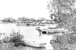 A river excursion, 1931 | |
| Location | |
| Country | Australia |
| State | Queensland |
| Region | South East Queensland |
| Physical characteristics | |
| Source | Blackall Range |
| Mouth | Maroochydore |
| Basin size | 630 km2 (240 sq mi) |
The suburb south of Airport and North of River and west of Motorway is known as Maroochy River.
Course
The watershed of the Maroochy River encompasses 630 square kilometres (240 sq mi) of undulating hills which have been cleared for agriculture and urban uses.[2] There are three dams in the catchment area including Wappa Dam, Cooloolabin Dam and Poona Dam which total to 27,997 megalitres (988.7×10⁶ cu ft) of capacity.[1]
There are two main arms: North and South Maroochy Rivers.[3] Tributaries of the river include Petrie Creek and its major tributary Paynter Creek, Eudlo Creek, Coolum Creek, Doonan Creek and Yandina Creek.[3]
There is one Canal system open to the river Maroochy Waters and a second Canal system with restricted access to river namely Twin Waters. There are also numerous lake systems which drain to the river and its creeks such as Sunshine Cove.
There are a number of named Islands in the river including Pincushion Island, Goat Island, Channel Island, Chambers Island & Bungee's Island.
Floods
Significant floods on the Maroochy River have occurred in 1893, 1951, 1974 and 1992.[4] In 1994 the Maroochy River flood warning system was set up to provide river height predictions for the Maroochy Shire Council.[4]
History
In the early days of settlement, the only way to travel from Yandina to Maroochydore was by boat along the Maroochy River.[5]
The growth of urban settlements in 1930 had improved the Maroochy River due to its transport developments.[5]
The mouth of the river was affected by the 2009 southeast Queensland oil spill, reaching about 2 kilometres (1.2 mi) upstream to the Maroochy Bridge.[6]
See also
References
- "Water resources - Overview - Queensland - Basin & Surface Water Management Area: Maroochy River". Australian Natural Resources Atlas. Department of the Environment, Water, Heritage and the Arts. Archived from the original on 22 June 2009. Retrieved 25 May 2009.
- "Maroochy River Catchment and Estuary". Healthy Waterways. Moreton Bay Waterways and Catchment Partnership. 2008. Archived from the original on 23 October 2009. Retrieved 26 May 2009.
- "Maroochy River". State of the Rivers report. Department of Environment and Resource Management. Archived from the original on 20 May 2009. Retrieved 25 May 2009.
- "Flood Warning System For The Maroochy River". Bureau of Meteorology (Australia). Archived from the original on 6 September 2008. Retrieved 25 May 2009.
- "Sunshine Coast Council - Heritage". Sunshine Coast Council. Archived from the original on 16 March 2019. Retrieved 15 May 2019.
- Janel Shorthouse; Sara Hicks; Bruce Atkinson (13 March 2009). "Oil spill spreads upstream". ABC Sunshine & Cooloola Coasts Queensland. Australian Broadcasting Corporation. Archived from the original on 16 March 2009. Retrieved 26 May 2009.
External links
![]()
Rivers of Queensland | |||||||||||||||
|---|---|---|---|---|---|---|---|---|---|---|---|---|---|---|---|
| |||||||||||||||
| |||||||||||||||
| |||||||||||||||
| |||||||||||||||
| |||||||||||||||
| |||||||||||||||