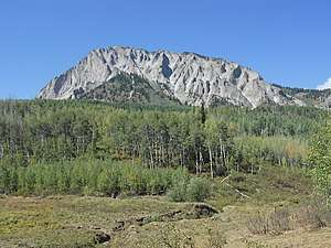
Marcellina Mountain
Marcellina Mountain is a prominent mountain summit in the West Elk Mountains range of the Rocky Mountains of North America. The 11,353-foot (3,460 m) peak is located in the Raggeds Wilderness of Gunnison National Forest, 15.0 miles (24.1 km) west by north (bearing 287°) of the Town of Crested Butte in Gunnison County, Colorado, United States.[1][2][3]
| Marcellina Mountain | |
|---|---|
 Marcellina Mountain | |
| Highest point | |
| Elevation | 11,353 ft (3,460 m) [1][2] |
| Prominence | 2,728 ft (831 m) [2] |
| Isolation | 5.08 mi (8.18 km) [2] |
| Listing | Colorado prominent summits |
| Coordinates | 38°55′48″N 107°14′38″W [3] |
| Geography | |
 Marcellina Mountain | |
| Location | Gunnison County, Colorado, U.S.[3] |
| Parent range | West Elk Mountains[2] |
| Topo map | USGS 7.5' topographic map Marcellina Mountain, Colorado[3] |
Mountain
gollark: The principle of negative indentation is simple enough: you put much whitespace before the outer bits of blocks, and less in the inner.
gollark: NEGATIVE VERTICAL TAB INDENTATION.
gollark: Besides, I have a much better solution.
gollark: Firecubez, consume apioforms! Stop making arguments, refusing to continue those due to a ”mental problem”, and then reengaging in them when someone says a related thing.
gollark: I really should deploy the thing™ where it adds a URL too.
See also
References
- The elevation of Marcellina Mountain includes an adjustment of +1.658 m (+5.44 ft) from NGVD 29 to NAVD 88.
- "Marcellina Mountain, Colorado". Peakbagger.com. Retrieved October 20, 2014.
- "Marcellina Mountain". Geographic Names Information System. United States Geological Survey. Retrieved October 20, 2014.
External links
This article is issued from Wikipedia. The text is licensed under Creative Commons - Attribution - Sharealike. Additional terms may apply for the media files.