Little Cone
Little Cone is a prominent mountain summit in the San Miguel Mountains range of the Rocky Mountains of North America. The 11,988-foot (3,654 m) peak is located in Uncompahgre National Forest, 15.0 miles (24.1 km) west (bearing 267°) of the Town of Telluride in San Miguel County, Colorado, United States.[1][2][3][4]
| Little Cone | |
|---|---|
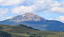 The mountain viewed from near Telluride. | |
| Highest point | |
| Elevation | 11,988 ft (3,654 m) [1][2] |
| Prominence | 1,840 ft (561 m) [3] |
| Isolation | 5.19 mi (8.35 km) [3] |
| Listing | Colorado prominent summits |
| Coordinates | 37°55′39″N 108°05′27″W [1] |
| Geography | |
 Little Cone | |
| Location | San Miguel County, Colorado, United States[4] |
| Parent range | San Miguel Mountains[3] |
| Topo map | USGS 7.5' topographic map Little Cone, Colorado[1] |
Mountain
gollark: I'm fairly sure that would destroy the Earth, although not the Sun.
gollark: They would have... 6355158815113313211503330468170308MJ of energy, assuming haevdrones mass 10 tonnnes total.
gollark: They would ALL be destroyed along with you.
gollark: Hold on
gollark: Also possibly the solar system?
See also
References
- "LITTLE CONE". NGS data sheet. U.S. National Geodetic Survey. Retrieved October 20, 2014.
- The elevation of Little Cone includes an adjustment of +1.645 m (+5.40 ft) from NGVD 29 to NAVD 88.
- "Little Cone, Colorado". Peakbagger.com. Retrieved October 20, 2014.
- "Little Cone". Geographic Names Information System. United States Geological Survey. Retrieved October 29, 2014.
External links
This article is issued from Wikipedia. The text is licensed under Creative Commons - Attribution - Sharealike. Additional terms may apply for the media files.