East Beckwith Mountain
East Beckwith Mountain is a prominent mountain summit in the West Elk Mountains range of the Rocky Mountains of North America. The 12,441-foot (3,792 m) peak is located in the West Elk Wilderness of Gunnison National Forest, 13.4 miles (21.5 km) west by south (bearing 264°) of the Town of Crested Butte in Gunnison County, Colorado, United States.[1][2][3][4]
| East Beckwith Mountain | |
|---|---|
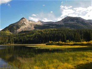 East Beckwith Mountain viewed from the northeast. The high point is the summit on the right. | |
| Highest point | |
| Elevation | 12,441 ft (3,792 m) [1][2] |
| Prominence | 2,492 ft (760 m) [3] |
| Isolation | 6.24 mi (10.04 km) [3] |
| Listing | Colorado prominent summits |
| Coordinates | 38°50′47″N 107°13′24″W [1] |
| Geography | |
 East Beckwith Mountain | |
| Location | Gunnison County, Colorado, U.S.[4] |
| Parent range | West Elk Mountains[3] |
| Topo map | USGS 7.5' topographic map Anthracite Range, Colorado[1] |
| Climbing | |
| Easiest route | hike |
Geology
East Beckwith Mountain is a laccolith, formed when magma intruded into Mancos Shale approximately 30 million years ago. Subsequently the softer, overlying sedimentary rock has eroded away, exposing the more resistant igneous rock. East Beckwith Mountain is one of over a dozen laccoliths in the West Elk and adjacent Elk Mountains. Of these laccoliths, East Beckwith Mountain is noted for its distinctive glacial landforms. On the north side of this elongated, east-west oriented mountain, there are five glacially carved cirques with intervening arêtes, and moraines fan out from the mountain's base.[5][6]
Historical names
- East Beckwith Mountain [4]
- Mount Beckwith
References
- "EAST BECKWITH". NGS data sheet. U.S. National Geodetic Survey. Retrieved October 20, 2014.
- The elevation of East Beckwith Mountain includes an adjustment of +1.924 m (+6.31 ft) from NGVD 29 to NAVD 88.
- "East Beckwith Mountain, Colorado". Peakbagger.com. Retrieved October 20, 2014.
- "East Beckwith Mountain". Geographic Names Information System. United States Geological Survey. Retrieved October 29, 2014.
- Prather, Thomas (1999). Geology of the Gunnison Country (2nd ed.). Gunnison, Colorado: B&B Printers. LCCN 82-177244.
- "Geologic Road Log of Kebler Pass" (PDF). United States Forest Service. Archived from the original (PDF) on 23 February 2017. Retrieved 12 April 2020.
External links
- East Beckwith Mountain CO, listsofjohn.com