Liberty Township, Parke County, Indiana
Liberty Township is one of thirteen townships in Parke County, Indiana, United States. As of the 2010 census, its population was 739 and it contained 324 housing units.[2]
Liberty Township | |
|---|---|
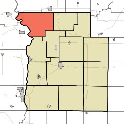 Location in Parke County | |
| Coordinates: 39°54′46″N 87°19′59″W | |
| Country | |
| State | |
| County | Parke |
| Government | |
| • Type | Indiana township |
| Area | |
| • Total | 39.29 sq mi (101.8 km2) |
| • Land | 38.92 sq mi (100.8 km2) |
| • Water | 0.37 sq mi (1.0 km2) 0.94% |
| Elevation | 636 ft (194 m) |
| Population (2010) | |
| • Total | 739 |
| • Density | 19/sq mi (7/km2) |
| Time zone | UTC-5 (Eastern (EST)) |
| • Summer (DST) | UTC-4 (EDT) |
| ZIP codes | 47832, 47862, 47952 |
| Area code(s) | 765 |
| GNIS feature ID | 453558 |
History
The W.H. York Round Barn, Bowsher Ford Covered Bridge, Marshall Covered Bridge, Mill Creek Covered Bridge, and Rush Creek Covered Bridge are listed on the National Register of Historic Places.[3]
Geography
According to the 2010 census, the township has a total area of 39.29 square miles (101.8 km2), of which 38.92 square miles (100.8 km2) (or 99.06%) is land and 0.37 square miles (0.96 km2) (or 0.94%) is water.[2]
Unincorporated towns
- Howard at 39.91615°N 87.375570°W
- Lodi at 39.950039°N 87.405848°W
- Sylvania at 39.918929°N 87.294457°W
- Tangier at 39.919206°N 87.318069°W
(This list is based on USGS data and may include former settlements.)
Cemeteries
The township contains these seven cemeteries: Brockway, Ephlin, Harvey, Miller, Rush Creek, Russell and Shirk.
School districts
- Turkey Run Community School Corporation
Political districts
- State House District 42
- State Senate District 38
References
- "Liberty Township, Parke County, Indiana". Geographic Names Information System. United States Geological Survey. Retrieved 2009-11-01.
- United States Census Bureau 2009 TIGER/Line Shapefiles
- IndianaMap
- "US Board on Geographic Names". United States Geological Survey. October 25, 2007. Retrieved 2017-05-09.
- "Population, Housing Units, Area, and Density: 2010 - County -- County Subdivision and Place -- 2010 Census Summary File 1". United States Census. Archived from the original on 2020-02-12. Retrieved 2013-05-10.
- "National Register Information System". National Register of Historic Places. National Park Service. July 9, 2010.
External links
- Indiana Township Association
- United Township Association of Indiana
- City-Data.com page for Liberty Township
Places adjacent to Liberty Township, Parke County, Indiana | |
|---|---|
Municipalities and communities of Parke County, Indiana, United States | ||
|---|---|---|
| Towns | Map of Indiana highlighting Parke County | |
| Townships | ||
| Unincorporated communities |
| |
| Ghost town | ||
| Footnotes | ‡This populated place also has portions in an adjacent county or counties | |