Howard Township, Parke County, Indiana
Howard Township is one of thirteen townships in Parke County, Indiana, United States. As of the 2010 census, its population was 341 and it contained 157 housing units.[2] The township includes the western end of Shades State Park and the southeast quarter of Turkey Run State Park.
Howard Township | |
|---|---|
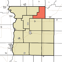 Location in Parke County | |
| Coordinates: 39°54′11″N 87°07′58″W | |
| Country | |
| State | |
| County | Parke |
| Government | |
| • Type | Indiana township |
| Area | |
| • Total | 23.82 sq mi (61.7 km2) |
| • Land | 23.75 sq mi (61.5 km2) |
| • Water | 0.07 sq mi (0.2 km2) 0.29% |
| Elevation | 705 ft (215 m) |
| Population (2010) | |
| • Total | 341 |
| • Density | 14.4/sq mi (5.6/km2) |
| Time zone | UTC-5 (Eastern (EST)) |
| • Summer (DST) | UTC-4 (EDT) |
| ZIP codes | 47859, 47872, 47989 |
| Area code(s) | 765 |
| GNIS feature ID | 453420 |
History
Howard Township was established about 1855, and named for General Howard, an early settler.[3]
Geography
According to the 2010 census, the township has a total area of 23.82 square miles (61.7 km2), of which 23.75 square miles (61.5 km2) (or 99.71%) is land and 0.07 square miles (0.18 km2) (or 0.29%) is water.[2]
Unincorporated towns
(This list is based on USGS data and may include former settlements.)
Cemeteries
.The township contains Lough Cemetery and Wolf Creek Cemetery.
Major highways
School districts
- Turkey Run Community School Corporation
Political districts
- State House District 41
- State Senate District 38
gollark: This produces lemon juice, somehow.
gollark: Lemons are fired into a lemonosphere volume, and then heated rapidly with pulsed lasers.
gollark: We use inertial confinement distillation.
gollark: What is the johnvertisement?
gollark: It has HYPERCAL™!
References
- "Howard Township, Parke County, Indiana". Geographic Names Information System. United States Geological Survey. Retrieved 2009-11-01.
- United States Census Bureau 2009 TIGER/Line Shapefiles
- IndianaMap
- "US Board on Geographic Names". United States Geological Survey. October 25, 2007. Retrieved 2017-05-09.
- "Population, Housing Units, Area, and Density: 2010 - County -- County Subdivision and Place -- 2010 Census Summary File 1". United States Census. Archived from the original on 2020-02-12. Retrieved 2013-05-10.
- History of Parke and Vermillion Counties, Indiana. B.F. Bowen & Cos. 1913. p. 185.
External links
- Indiana Township Association
- United Township Association of Indiana
- City-Data.com page for Howard Township
Places adjacent to Howard Township, Parke County, Indiana | |
|---|---|
Municipalities and communities of Parke County, Indiana, United States | ||
|---|---|---|
| Towns | Map of Indiana highlighting Parke County | |
| Townships | ||
| Unincorporated communities |
| |
| Ghost town | ||
| Footnotes | ‡This populated place also has portions in an adjacent county or counties | |
This article is issued from Wikipedia. The text is licensed under Creative Commons - Attribution - Sharealike. Additional terms may apply for the media files.