Millcreek Township, Fountain County, Indiana
Millcreek Township is one of eleven townships in Fountain County, Indiana, United States. As of the 2010 census, its population was 1,406 and it contained 815 housing units.[1]
Millcreek Township | |
|---|---|
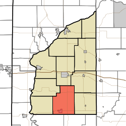 Location of Millcreek Township in Fountain County | |
| Coordinates: 40°00′33″N 87°15′29″W | |
| Country | United States |
| State | Indiana |
| County | Fountain |
| Government | |
| • Type | Indiana township |
| Area | |
| • Total | 42.94 sq mi (111.2 km2) |
| • Land | 42.71 sq mi (110.6 km2) |
| • Water | 0.24 sq mi (0.6 km2) |
| Elevation | 692 ft (211 m) |
| Population (2010) | |
| • Total | 1,406 |
| • Density | 32.9/sq mi (12.7/km2) |
| FIPS code | 18-49392 |
| GNIS feature ID | 453627 |
History
The Clinton F. Hesler Farm was listed on the National Register of Historic Places in 1989.[2]
Geography
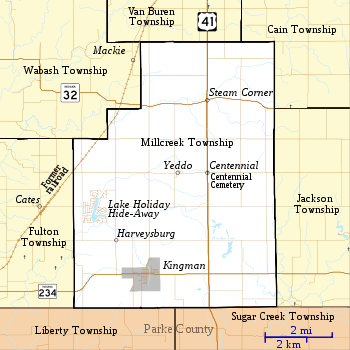
According to the 2010 census, the township has a total area of 42.94 square miles (111.2 km2), of which 42.71 square miles (110.6 km2) (or 99.46%) is land and 0.24 square miles (0.62 km2) (or 0.56%) is water.[1] It contains the town of Kingman in the southwest along Indiana State Road 234. The unincorporated community of Centennial, with its cemetery of the same name,[3] lies to the northeast on U.S. Route 41;[4] further north, at the intersection with Indiana State Road 32,[5] lies Steam Corner. Harveysburg is north of Kingman and Yeddo is west of Centennial.
Education
Millcreek Township residents may obtain a free library card at the Kingman-Millcreek Public Library in Kingman.[6]
References
- "Population, Housing Units, Area, and Density: 2010 - County -- County Subdivision and Place -- 2010 Census Summary File 1". United States Census. Archived from the original on 2020-02-12. Retrieved 2013-05-10.
- "National Register Information System". National Register of Historic Places. National Park Service. July 9, 2010.
- "Centennial Cemetery". Geographic Names Information System. United States Geological Survey. Retrieved 2011-09-10.
- "U.S. Route 41". Highway Explorer. Archived from the original on 2010-12-07. Retrieved 2010-09-21.
- "State Road 32". Highway Explorer. Archived from the original on 2011-07-11. Retrieved 2010-09-21.
- "About us". Kingman-Millcreek Public Library. Retrieved 7 March 2018.
External links
Places adjacent to Millcreek Township, Fountain County, Indiana | |
|---|---|
Municipalities and communities of Fountain County, Indiana, United States | ||
|---|---|---|
| Cities | Map of Indiana highlighting Fountain County | |
| Towns | ||
| Townships | ||
| Unincorporated communities | ||