Kutubdia Upazila
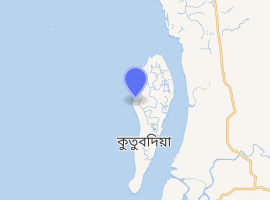
Kutubdia (Bengali: কুতুবদিয়া) is an Upazila of Cox's Bazar District[3] in the Division of Chittagong, Bangladesh. The upazila consists of an island in the Bay of Bengal, off the coast near Chakaria, Cox's Bazar.
Kutubdia Upazila কুতুবদিয়া | |
|---|---|
Upazila | |
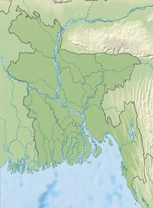
 Kutubdia Upazila Location in Bangladesh | |
| Coordinates: 21°49′N 91°51.5′E | |
| Country | |
| Division | Chittagong Division |
| District | Cox's Bazar District |
| Government | |
| • Member of Parliament | Asheq Ullah Rafiq (Bangladesh Awami League) |
| • Upazila Chairman | Faridul Islam Chowdhury |
| Area | |
| • Total | 215.8 km2 (83.3 sq mi) |
| Population (2011) | |
| • Total | 125,279 |
| • Density | 580/km2 (1,500/sq mi) |
| Time zone | UTC+6 (BST) |
| Postal code of Bangladesh | 4720 |
| Website | kutubdia |
 | |
 Bangladesh | |
| |
| Location | Kutubdia Bangladesh |
|---|---|
| Coordinates | 21°51′54″N 91°50′33″E |
| Year first constructed | 1846 (first) |
| Year first lit | 2004 (current) |
| Foundation | concrete base |
| Construction | metal skeletal tower (current) masonry tower (first)[1] |
| Tower shape | square pyramidal skeletal tower with balcony and lantern |
| Markings / pattern | white and red horizontal bands, white and red horizontal daymark on the top[1] |
| Tower height | 35 metres (115 ft) (current)[2] 34 metres (112 ft) (first)[1] |
| Focal height | 37 metres (121 ft) (current)[2] 37 metres (121 ft) (first)[1] |
| Range | 20 nautical miles (37 km; 23 mi)[2] |
| Characteristic | Fl (3) W 10s.[2] |
| Racon | K[2] |
| Admiralty number | F1054 [2] |
| NGA number | 26760[2] |
| ARLHS number | BAN-004[1] |
| Managing agent | Bangladesh Department of Shipping[1] |
History
A police station at Kutubdia was established in 1917. The island was upgraded into an upazila in 1983. Abdul Malek Shah was born on this island.
Kutubdia has an area of 36 square miles (93 km2), 18 miles (29 km) in length and 2 miles (3.2 km) in breadth. It is famous for the only lighthouse in Bangladesh which was built by the British during the British rule. Kutubdia is rich in producing salt and dried fish, locally known as 'Shutki'.
Geography
Kutubdia is located at 21.8167°N 91.8583°E. It has 58,463 households and a total area of 215.8 square kilometres (83.3 sq mi). Climate change and sea level rise threaten to submerge the island in the Bay of Bengal.[4][5]
Demographics
According to the 2011 Bangladesh census, Kutubdia had a population of 125,000. Males constituted 51% of the population, and females 49%. The population aged 18 or over was 41, 755. Kutubdia had an average literacy rate of 24.1% (7+ years), the national average being 32.4% literate. The most populated area is Ali Akbar Dale. Thousands of visitors visit this island daily due to journeys and other business related work.
Administration
Kutubdia has 6 Unions, 9 Mauzas/Mahallas, and about 100 villages. It has two towns such as Baraghop and Dhurung.
See also
References
- "Bangladesh". The Lighthouse Directory. University of North Carolina at Chapel Hill. Retrieved 30 September 2016.
- List of Lights, Pub. 112: Western Pacific and Indian Oceans Including the Persian Gulf and Red Sea (PDF). List of Lights. United States National Geospatial-Intelligence Agency. 2016.
- Md Wajed Ali Kutubi (2012), "Kutubdia Upazila", in Sirajul Islam and Ahmed A. Jamal (ed.), Banglapedia: National Encyclopedia of Bangladesh (Second ed.), Asiatic Society of Bangladesh
- Vidal, John (2013-01-29). "Sea change: the Bay of Bengal's vanishing islands". London: The Guardian. Retrieved 2013-03-20.
- Kristof, Nicholas (January 19, 2018). "Climate change threatens Kutubdia". NYTimes. Retrieved January 19, 2018.
| Upazila/Thana: | ||
|---|---|---|
Capital: Chattogram | ||
| Bandarban District | 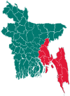 | |
| Brahmanbaria District | ||
| Chandpur District | ||
| Chattogram District | ||
| Cumilla District |
| |
| Cox's Bazar District | ||
| Feni District | ||
| Khagrachari District |
| |
| Lakshmipur District | ||
| Noakhali District | ||
| Rangamati District | ||