Kuala Langat District
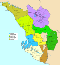
The Kuala Langat District is a district of Selangor, Malaysia. It is situated in the southwestern part of Selangor. It covers an area of 858 square kilometres, and had a population of 213,876 at the 2010 Census (exclude foreign).[4] It is bordered by the districts of Klang and Petaling to the north and Sepang to the east. The Strait of Malacca forms its western border.
Kuala Langat District | |
|---|---|
| Daerah Kuala Langat | |
| Other transcription(s) | |
| • Jawi | كوالا لڠات |
| • Chinese | 瓜拉冷岳县 |
| • Tamil | குவாலா லாஙாட் |
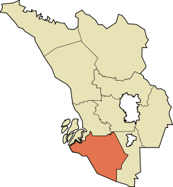 Location of Kuala Langat District in Selangor | |
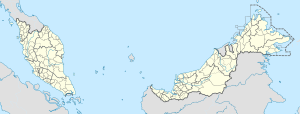 Kuala Langat District Location of Kuala Langat District in Malaysia | |
| Coordinates: 2°50′N 101°30′E | |
| Country | |
| State | |
| Seat | Teluk Datok |
| Largest town | Banting |
| Local area government(s) | Kuala Langat Municipal Council |
| Government | |
| • District officer | Rosli Othman[1] |
| • Sultan's Representative | Mohamed Al Haj Harun[2] |
| Area | |
| • Total | 858 km2 (331 sq mi) |
| Population (2010)[4] | |
| • Total | 213,876 |
| • Density | 250/km2 (650/sq mi) |
| Time zone | UTC+8 (MST) |
| • Summer (DST) | UTC+8 (Not observed) |
| Postcode | 425xx-428xx, 471xx |
| Calling code | +6-03-31, +6-03-51, +6-03-5614, +6-03-80 |
| Vehicle registration plates | B |

Among the major towns in Kuala Langat are Banting, Jugra, Teluk Datok, Morib and an island Carey Island.
Administrative divisions
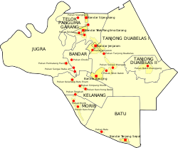
Kuala Langat District is divided into 7 mukims, which are:[5]
- Bandar
- Batu
- Jugra
- Kelanang
- Morib
- Tanjung 12
- Teluk Panglima Garang
Tourist attractions
Kuala Langat is famous for its agricultural produce, industries that recycle scrap metal, home stay programmes for tourists and for its National Space Centre in Kanchong Darat. Local farmers transform scrap metal from cars, electronics and other household appliances into large 12 meter transformers. [6]
- Malaysia Paragliding Flight Park
Infrastructure
Putrajaya and the Kuala Lumpur International Airport (KLIA), linked by new highways, have become the catalyst for Kuala Langat’s development. Road networks and infrastructure in the district are good, making it viable for manufacturers to transport their finished goods on freight trucks to Kuala Lumpur, KLIA and Port Klang.
Bandar Saujana Putra, located in the far-north of the district, was established in 2003 by LBS Bina Berhad and is located near Putra Heights, UEP Subang Jaya (USJ) and Puchong, as well as Cyberjaya, Putrajaya, and Teluk Panglima Garang. [7]
The Telok Panglima Garang Free Trade Zone, industries manufacturing electronic components and car parts have created many job opportunities for locals.
Morib is being moulded into an education hub and that plans were afoot to set up a few educational institutions in Jugra. Currently there is the Kuala Langat Community College and Industrial Training Institute. Other institutions being built are a matriculation college, a polytechnic and a Mara skills training institute.
Federal Parliament and State Assembly Seats

List of Kuala Langat district representatives in the Federal Parliament (Dewan Rakyat)
| Parliament | Seat Name | Member of Parliament | Party |
|---|---|---|---|
| P112 | Kuala Langat | Xavier Jayakumar | Pakatan Harapan (PH-PKR) |
| P113 | Sepang | Mohamed Hanipa Maidin | Pakatan Harapan (PH-AMANAH) |
List of Kuala Langat district representatives in the State Legislative Assembly (Dewan Undangan Negeri)
| Parliament | State | Seat Name | State Assemblyman | Party |
|---|---|---|---|---|
| P112 | N51 | Sijangkang | Ahmad Yunus Hairi | Perikatan Nasional (PAS) |
| P112 | N52 | Banting | Lau Weng San | Pakatan Harapan (DAP) |
| P112 | N53 | Morib | Hasnul Baharuddin | Pakatan Harapan (AMANAH) |
| P113 | N54 | Tanjong Sepat | Borhan bin Ahmad Shah | Pakatan Harapan (PKR) |
| P113 | N55 | Dengkil | Adhif Syan bin Abdullah | Pakatan Harapan (PPBM) |
References
- "Portal Rasmi PDT Kuala Langat Perutusan Pegawai Daerah Kuala Langat". www2.selangor.gov.my.
- "Portal Rasmi PDT Kuala Langat Orang Besar Daerah". www2.selangor.gov.my.
- "Portal Rasmi PDT Kuala Langat Profil Kuala Langat". www2.selangor.gov.my.
- "Population Distribution and Basic Demographic Characteristics, 2010" (PDF). Department of Statistics, Malaysia. Archived from the original (PDF) on 22 May 2014. Retrieved 19 April 2012.
- http://apps.water.gov.my/jpskomuniti/dokumen/JPS_KOMUNITI_%20KLGT_OKT_20112.pdf
- https://gbtimes.com/man-transforms-scrap-metal-12-metre-transformer
- "Kelana Jaya and Ampang LRT extension services to begin June 30". www.thesundaily.my.