Kuala Pilah District
The Kuala Pilah District is a district in central Negeri Sembilan, Malaysia.
Kuala Pilah District | |
|---|---|
| Daerah Kuala Pilah | |
| Other transcription(s) | |
| • Jawi | كوالا ڤيله |
| • Chinese | 瓜拉庇劳县 |
| • Tamil | கோலா பிலா |
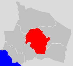 Location of Kuala Pilah District in Negeri Sembilan | |
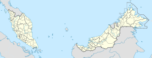 Kuala Pilah District Location of Kuala Pilah District in Malaysia | |
| Coordinates: 2°45′N 102°15′E | |
| Country | |
| State | |
| Seat | Kuala Pilah |
| Local area government(s) | Kuala Pilah District Council |
| Government | |
| • District officer | Syahru Nizam Saleh[1] |
| Area | |
| • Total | 1,090.40 km2 (421.01 sq mi) |
| Population (2010)[3] | |
| • Total | 64,120 |
| • Density | 59/km2 (150/sq mi) |
| Time zone | UTC+8 (MST) |
| • Summer (DST) | UTC+8 (Not observed) |
| Postcode | 72xxx |
| Calling code | +6-06 |
| Vehicle registration plates | N |
Administrative divisions
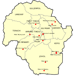
Kuala Pilah District is divided into 11 mukims, which are:[4]
- Ampang Tinggi
- Johol
- Juasseh
- Kepis
- Langkap
- Parit Tinggi
- Pilah
- Seri Menanti
- Terachi
- Ulu Jempol
- Ulu Muar
The district also home to Sri Menanti, the official residence of the Yang di-Pertuan Besar of Negeri Sembilan.
gollark: Thanks!
gollark: Wait, WHAT?!
gollark: Yes, go.
gollark: nXg5XAR in about 20 seconds.
gollark: ToD xx:25:11, AR at xx:23:11, I'll post the code when it's time.
See also
- Districts of Malaysia
References
- http://pilah.ns.gov.my/pdtkp/my/info/perutusan-pegawai-daerah-kuala-pilah
- Sidik, Mazani bin. "PDTKP - Mengenai Kami". pilah.ns.gov.my.
- "Population Distribution and Basic Demographic Characteristics, 2010" (PDF). Department of Statistics, Malaysia. Archived from the original (PDF) on 22 May 2014. Retrieved 19 April 2012.
- http://apps.water.gov.my/jpskomuniti/dokumen/jps%20@%20komuniti%20Kuala%20Pilah-submit.pdf
| Wikimedia Commons has media related to Kuala Pilah District. |
Capital: Seremban | |||||||||||
| Topics |
| ||||||||||
| Society |
| ||||||||||
| Administrative divisions |
| ||||||||||
| |||||||||||
This article is issued from Wikipedia. The text is licensed under Creative Commons - Attribution - Sharealike. Additional terms may apply for the media files.