Kota Tinggi District
The Kota Tinggi District is a district in Johor, Malaysia. Its capital is Kota Tinggi Town.[3]
Kota Tinggi District | |
|---|---|
| Daerah Kota Tinggi | |
| Other transcription(s) | |
| • Jawi | دايره كوتا تيڠڬي |
| • Chinese | 哥打丁宜县 |
| • Tamil | கோத்தா திங்கி |
 Flag | |
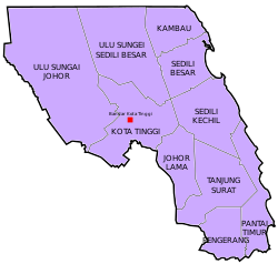
 Location of Kota Tinggi District in Johor | |
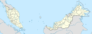
 Kota Tinggi District Location of Kota Tinggi District in Malaysia | |
| Coordinates: 1°44′N 103°54′E | |
| Country | |
| State | |
| Seat | Kota Tinggi |
| Local area government(s) | Kota Tinggi District Council (Kota Tinggi) Pengerang Municipal Council (Pengerang) |
| Government | |
| • District officer | Haji Farizal bin Ismail |
| Area | |
| • Total | 3,488.7 km2 (1,347.0 sq mi) |
| Population (2010)[2] | |
| • Total | 176,302 |
| • Density | 51/km2 (130/sq mi) |
| Time zone | UTC+8 (MST) |
| • Summer (DST) | UTC+8 (Not observed) |
| Postcode | 81xxx |
| Calling code | +6-07 |
| Vehicle registration plates | J |
Kota Tinggi town and other settlements of Kuala Sedili, Sungai Rengit and Pengerang are administered by Kota Tinggi District Council, which is based in Kota Tinggi town and Pengerang Municipal Council for southern area based in Pengerang.
Geography
The district has an area of 3,482 km2. It is the largest district in Johor which covers 18.34% of the state area.[4]
Demographics
The district has a total population of 200,000 people. Its population growth rate in 2000 was 1.08%.[5]
Government
The district is governed by two local authorities, which are Kota Tinggi District Council and Pengerang Municipal Council.[6] The Kota Tinggi District Council governs northwestern part of the district. Launched on 16 January 2017, the Pengerang Municipal Council previously known as Pengerang Local Authority governs the southeastern part of the district over an area of 1,288.3 km2 which is administered by Johor Corporation.[7]
Administrative divisions

The district consists of 10 mukims, which are:[8]
- Johor Lama
- Kambau
- Kota Tinggi Town
- Pantai Timur
- Pengerang
- Sedili Besar
- Sedili Kechil
- Tanjung Surat
- Ulu Sungai Johor
- Ulu Sungai Sedili Besar
Towns
Geology
Main rivers that pass through the district are Johor River, Lebam River, Santi River, Sedili Besar River and Sedili Kecil River.[8]
Economy
The main economy activities in the district are ecotourism, agriculture, biotechnology, petrochemical and oil and gas.[9] 60% of the district land is used for agriculture purpose.[8] In Desaru, currently the Johor state government is developing an integrated tourism area which spreads over an area of 1,578 hectares.[10]
Tourist attractions
Transportation
The district is served by TransJohor public buses linking Kota Tinggi Town to Larkin Sentral Terminal in Johor Bahru City and also other destinations within the district, such as Bandar Penawar.[11]
See also
References
- "Profil Daerah". ptj.johor.gov.my.
- "Population Distribution and Basic Demographic Characteristics, 2010" (PDF). Department of Statistics, Malaysia. Archived from the original (PDF) on 22 May 2014. Retrieved 19 April 2012.
- Prashant K. Srivastava; Prem Chandra Pandey; Pavan Kumar; Akhilesh Singh Raghubanshi; Dawei Han, eds. (2016). Geospatial Technology for Water Resource Applications. CRC Press. ISBN 978-13-153-5382-1.
- "Jabatan Perancangan Bandar dan Desa Negeri Johor" (PDF). Plan Malaysia @ Johor (in Malay). Retrieved 26 March 2018.
- http://jpbd.johor.gov.my/images/jpbd_DokumenTerbitan/Handbook.pdf
- "Archived copy" (PDF). Archived from the original (PDF) on 21 July 2018. Retrieved 6 April 2018.CS1 maint: archived copy as title (link)
- https://www.nst.com.my/news/2017/01/204574/new-local-authority-launched-oversee-johors-pipc
- http://apps.water.gov.my/jpskomuniti/dokumen/J@K_LPD_JUN_Kota%20Tinggi.pdf
- "Muafakat ke Arah #Johor Berkemajuan" (PDF). Muafakat Johor (in Malay). Retrieved 17 March 2018.
- "State govt's moves set to give Johor economy a boost". The Sun Daily. 23 November 2017. Retrieved 5 March 2018.
- "Bus Routes And Schedule". Pengangkutan Awam Johor. Retrieved 17 March 2018.
| Wikimedia Commons has media related to Kota Tinggi District. |