Küçükçekmece
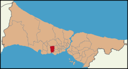
Küçükçekmece (pronounced [cyˈtʃyctʃecmedʒe]; from earlier Küçükçökmece "little depression"; ancient Bathonea) is a suburb of Istanbul, Turkey 23 km west of the city, on the European shore of the sea of Marmara.[2]
Küçükçekmece | |
|---|---|
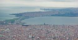
 Aerial view of Küçükçekmece | |
 | |
 Küçükçekmece | |
| Coordinates: 41°0′N 28°48′E | |
| Country | Turkey |
| Province | İstanbul |
| Government | |
| • Mayor | Kemal Çebi (CHP) |
| • Kaymakam | Harun Kaya |
| Area | |
| • District | 37.73 km2 (14.57 sq mi) |
| Population (2018)Kaynak | |
| • District | 770,317 |
| • District density | 20,171/km2 (52,240/sq mi) |
| Website | www.kucukcekmece.bel.tr www.kucukcekmece.gov.tr/ |
Location
Küçükçekmece lies on the European shore of the Sea of Marmara, on a lagoon named Lake Küçükçekmece. Across the inlet is the district of Avcılar and the campus of Istanbul University. The inlet is connected to the Sea of Marmara by a very narrow channel so the water is not salty. The streams running into the inlet now carry industrial waste and the inlet is highly polluted but efforts are being made to clean it. There used to be wildlife and many kinds of birds and efforts to get the wildlife back are taking effect slowly.
History
The lagoon has almost always been controlled by whichever imperial power was in control of Istanbul as the Via Egnatia (the road from Constantinopolis/Istanbul to western Europe) passed by here.
According to the Ottoman General Census of 1881/82-1893, the kaza of Küçükçekmece had a total population of 17.975, consisting of 10.945 Greeks, 5.340 Muslims, 1.396 Armenians, 61 Catholics, 31 Latins, 15 Bulgarians and 187 foreign citizens.[3]
Until the 1950s Küçükçekmece was a popular weekend excursion, people would come by train from Istanbul to swim, fish for eels or just sit by the water, while children played in the woods.
However the land here is flat, rising slightly away from the shore, and as such is easily built upon so as bigger and bigger roads have been built the area has become industrial and crowded with huge housing projects. This development is still going on and is indeed accelerated as the TEM motorway to Europe passes through here now. The İkitelli area in particular is very industrial and still more factories are being built. The Nuclear Energy Research center is on the lake side.
Already during the Greek and Roman periods the site of Küçükçekmece has been inhabited. The ruins of this town, always remained visible, have been studied extensively in 1930 by the Swiss archeologist Ernest Mamboury,[4] who - basing upon ancient sources - identified the settlement with the town of Regium (Ρήγιον in Greek).[4] In 2009 a new identification has been proposed, this time with the Greek and Roman city of Bathonea.[5][6] Excavations are presently carried on under the direction of Dr. Şengül Aydıngün, an associate Professor of the Kocaeli University.
The settlement lies 20 km west from Istanbul. The site is eight kilometers wide, reaching a small inlet west of Istanbul on the banks of Lake Küçükçekmece. Some remains of this city could be submerged in the waters of this lake. A researcher found in the middle of the lake a lighthouse that belongs to the settlement. If this is verified, it'll represent one of just three Roman lighthouses known to have existed in the eastern Mediterranean, next to those at Alexandria and Patara.
Küçükçekmece today
The population of Küçükçekmece is growing fast and it is acquiring schools, supermarkets, shopping centres and other facilities. However, in most parts of Küçükçekmece this is very much a poor, working-class neighbourhood, with much crime in dirty streets where men gather in badly lit cafes to play cards, drink tea and smoke cheap cigarettes. Most of the housing is illegally built gecekondu. Most of the people are recent migrants from Anatolia, increasingly from the troubled south-east. Traditionally there has been much left-wing sympathy, but recently it seems changing to the central right-wing.
At sunset after walking by the lakeside, young people will find somewhere to sit, and they will drink Turkish tea, that is one of the bests Küçükçekmece offers.
Küçükçekmece, Başakşehir, Bağcılar, Gaziosmanpaşa, Esenler, Bayrampaşa, Zeytinburnu, and Fatih are home to refugees of Syrian origin.[7]
Places of interest
A historic bridge, built by Ottoman architect Sinan, crosses the mouth of the lagoon. The bridge has been restored and is well maintained.
Sports
The 1911-founded football club Küçükçekmece S.K. play in the Istanbul First Amateur League.
Transportation
The Sirkeci-Halkalı railway line passes through Küçükçekmece district serving the railway stations Küçükçekmece, Soğuksu, Kanarya and Halkalı.
Neighborhoods
Neighborhoods are Atakent, Atatürk, Beşyol, Cennet, Cumhuriyet, Fatih, Fevzi Çakmak, Gültepe, Halkalı Merkez, İnönü, İstasyon, Kanarya, Kartaltepe, Kemalpaşa, Mehmet Akif, Söğütlüçeşme, Sultanmurat, Tevfikbey, Yarımburgaz, Yenimahalle, Yeşilova.[8]
See also
References
- http://www.istanbulsaglik.gov.tr/w/anasayfalinkler/pano2014/yuzolcumleri_2014.pdf
- "..::Türkiye İstatistik Kurumu Web sayfalarına Hoş Geldiniz::." www.tuik.gov.tr.
- Kemal Karpat (1985), Ottoman Population, 1830-1914, Demographic and Social Characteristics, The University of Wisconsin Press, p. 138-139
- Mamboury, p. 569 (1953)
- "Heritage Key". Archived from the original on 2011-07-27. Retrieved 2011-02-02.
- "Greatest finds of the year". The Independent. January 7, 2010.
- HAYATA DESTEK (31 August 2013). Syrian Refugees in Turkey (PDF) (Report). SUPPORT TO LIFE. pp. 4–5.
- Belediyesi, Küçükçekmece. "MAHALLELER". kucukcekmece.istanbul.
Sources
- Mamboury, Ernest (1953). The Tourists' Istanbul. Istanbul: Çituri Biraderler Basımevi.
