Grade I listed buildings in Berkshire
There are approximately 372,905 listed buildings in England and 2.5% of these are Grade I.[1] This page is a list of these buildings in the county of Berkshire, ordered by building name within place name within district.
Berkshire shown within England
Bracknell Forest
| Name | Location | Type | Completed [note 1] | Date designated | Grid ref.[note 2] Geo-coordinates |
Entry number [note 3] | Image |
|---|---|---|---|---|---|---|---|
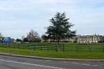
| Grotto in the Grounds of Ascot Place to South of House at West end of lake | Winkfield | Grotto | c. 1750 | 20 December 1972 | SU9131171181 51°25′56″N 0°41′16″W |
1390475 |  Grotto in the Grounds of Ascot Place to South of House at West end of lake |
Reading
| Name | Location | Type | Completed [note 1] | Date designated | Grid ref.[note 2] Geo-coordinates |
Entry number [note 3] | Image |
|---|---|---|---|---|---|---|---|
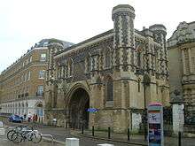
| Abbey Gate | The Forbury, Reading | Abbey gatehouse | 12th century to 14th century | 22 March 1957 | SU7188273556 51°27′23″N 0°58′01″W |
1155691 | |
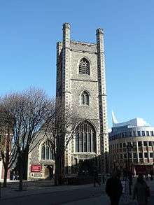
| St Laurence's Church and churchyard | Reading | Church | Dated 1727 | 22 March 1957 | SU7170873548 51°27′23″N 0°58′10″W |
1113532 | |
| Reading Minster | Reading | Church | Norman | 22 March 1957 | SU7141173318 51°27′16″N 0°58′25″W |
1113573 | |
| Greyfriars Church | Friar Street | Church | In use 18th Century | 22 March 1957 | SU7121073589 51°27′25″N 0°58′35″W |
1321952 | |
| Large barn to south-east of Chazey Court farmhouse | Caversham | Barn | Late C17/early 18th century | 24 October 1951 | SU6915775161 51°28′16″N 1°00′21″W |
1113603 | |
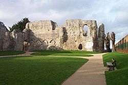
| Reading Abbey Ruins | Forbury Gardens | Abbey | Now ruined | 22 March 1957 | SU7200273549 51°27′23″N 0°57′54″W |
1113477 |
_(cropped).jpg)

_(cropped).jpg)
Slough
| Name | Location | Type | Completed [note 1] | Date designated | Grid ref.[note 2] Geo-coordinates |
Entry number [note 3] | Image |
|---|---|---|---|---|---|---|---|
| Baylis House, including forecourt walls and pavilions adjoining to North East | Stoke Poges Lane | House | c. 1695 | 29 September 1950 | SU9694780868 51°31′06″N 0°36′15″W |
1113389 | 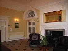 Baylis House, including forecourt walls and pavilions adjoining to North East |
| Church of St Laurence | Upton Court Road, Upton-cum-Chalvey | Church | Early 12th century | 29 September 1950 | SU9807479094 51°30′08″N 0°35′18″W |
1251379 | 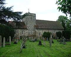 Church of St Laurence |
| Church of St Mary, Langley | St Mary's Road | Church | 1623 | 29 September 1950 | TQ0048379533 51°30′21″N 0°33′13″W |
1135750 | |
| Former Service Block Adjoining Baylis House to North East | Stoke Poges Lane | Training College | 1984 | 29 September 1950 | SU9697280892 51°31′07″N 0°36′14″W |
1251374 |  |
| Stable approximately 40 Metres to North of Baylis House | Godolphin Court, Stoke Poges Lane | Stable | Mid to Late 18th century | 29 September 1950 | SU9697280918 51°31′08″N 0°36′14″W |
1313126 | |
West Berkshire
| Name | Location | Type | Completed [note 1] | Date designated | Grid ref.[note 2] Geo-coordinates |
Entry number [note 3] | Image |
|---|---|---|---|---|---|---|---|
| Church of St Mary | Church Road, Aldermaston | Church | 12th century | 14 April 1967 | SU5965564975 51°22′51″N 1°08′39″W |
1117319 | |
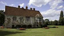
| Church of St Mary | Parsonage Green, Aldworth | Church | 12th century | 24 November 1966 | SU5540379381 51°30′38″N 1°12′11″W |
1313119 | 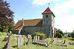 Church of St Mary |
| Church of St Clement | Church Lane, Ashampstead | Church | Early 13th century | 14 April 1967 | SU5641876793 51°29′14″N 1°11′20″W |
1212118 | 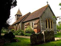 Church of St Clement |
| Basildon Park | Basildon | Country House | 1776-83 | 14 April 1967 | SU6107778160 51°29′57″N 1°07′17″W |
1221097 | |
| Church of St Bartholemew | Basildon | Church | Late 13th century | 14 April 1967 | SU6116679270 51°30′33″N 1°07′12″W |
1221092 | |
| Church of St Nicholas | Beedon | Church | Early 13th century | 24 November 1966 | SU4823678125 51°30′00″N 1°18′23″W |
1136040 | 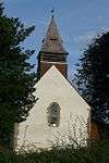 Church of St Nicholas |
| Church of St Mary | Bucklebury | Church | c. 1450 | 14 April 1967 | SU5530470867 51°26′03″N 1°12′21″W |
1212695 | 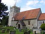 Church of St Mary |
| Church of St Margaret | Catmore | Church | 12th century | 24 November 1966 | SU4539080164 51°31′07″N 1°20′50″W |
1210997 | 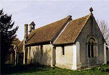 Church of St Margaret |
| Church of St Andrew | Mount Lane, Chaddleworth | Church | 1742 | 24 November 1966 | SU4115277924 51°29′56″N 1°24′31″W |
1210713 | 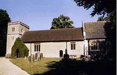 Church of St Andrew |
| Church of St Swithin | Church Lane, Combe, Berkshire | Church | 12th century | 6 February 1962 | SU3681360741 51°20′40″N 1°28′22″W |
1221122 |  Church of St Swithin |
| Church of St Mary | Church Hill, East Ilsley | Church | 13th century | 24 November 1966 | SU4933080918 51°31′30″N 1°17′25″W |
1136120 |  Church of St Mary |
| Parish Church of St Michael, Enborne | Enborne | Church | 12th century | 6 April 1967 | SU4358565773 51°23′22″N 1°22′30″W |
1220252 |  Parish Church of St Michael, Enborne |
| Church of St Mark | Englefield | Church | 13th century | 14 April 1967 | SU6238571995 51°26′37″N 1°06′14″W |
1213321 | 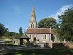 Church of St Mark |
| Church of All Saints | Farnborough Village, Farnborough | Church | 11th century | 24 November 1966 | SU4351581936 51°32′05″N 1°22′27″W |
1117199 |  Church of All Saints |
| St Thomas' Church, East Shefford | East Shefford, Great Shefford | Church | Norman | 11 July 1983 | SU3905874679 51°28′11″N 1°26′21″W |
1321841 | |
| Sandleford Priory | Newton Road, Greenham | Priory | c. 1800 | 6 June 1952 | SU4768164440 51°22′37″N 1°18′59″W |
1220371 | |
| Pair of Gate Piers 103 Metres South of East End of Church | Park Lane, Hampstead Marshall | Gate Pier | Early C18, before 1718 | 6 March 1985 | SU4203466605 51°23′49″N 1°23′50″W |
1136047 | _(geograph_2285756).jpg) Pair of Gate Piers 103 Metres South of East End of Church |
| Pair of Gate Piers 204 Metres East of Entrance to Home Farm | Park Lane, Hampstead Marshall | Gate Pier | Early C18, before 1718 | 6 March 1985 | SU4191866685 51°23′52″N 1°23′56″W |
1136042 | _(geograph_2285762).jpg) Pair of Gate Piers 204 Metres East of Entrance to Home Farm |
| Pair of Gate Piers 210 Metres Due South of Church Tower | Park Lane, Hampstead Marshall | Gate Pier | Late 17th century | 6 March 1985 | SU4198066538 51°23′47″N 1°23′53″W |
1117219 | _(geograph_2285778).jpg) Pair of Gate Piers 210 Metres Due South of Church Tower |
| Pair of Gate Piers 30 Metres South of East End of Church | Park Lane, Hampstead Marshall | Gate Pier | Early C18, before 1718 | 6 March 1985 | SU4200566711 51°23′52″N 1°23′51″W |
1117218 | .jpg) Pair of Gate Piers 30 Metres South of East End of Church |
| Three Pairs of Gate Piers and Walls Around Gardens and Terrace at Home Farm | Park Lane, Hampstead Marshall | Gate pier | Late 17th century | 6 March 1985 | SU4188866608 51°23′49″N 1°23′57″W |
1136034 | _(geograph_2285849).jpg) Three Pairs of Gate Piers and Walls Around Gardens and Terrace at Home Farm |
| Church of St Mary | Church Street, Hampstead Norreys | Church | 12th century | 24 November 1966 | SU5293276259 51°28′58″N 1°14′21″W |
1135735 | 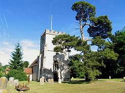 Church of St Mary |
| Church of St Mark and St Luke | Kintbury | Church | 11th century | 6 February 1962 | SU3727667964 51°24′34″N 1°27′56″W |
1319539 | 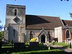 Church of St Mark and St Luke |
| Church of St Michael and All Angels | Market Place, Lambourn | Church | Late Norman | 6 February 1962 | SU3260678957 51°30′31″N 1°31′54″W |
1113695 | 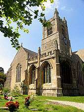 Church of St Michael and All Angels |
| West Berkshire Museum | Wharf Street, Newbury | Museum | 1626-7 | 29 September 1950 | SU4724367135 51°24′05″N 1°19′20″W |
1289770 | |
| St Nicolas Church, Newbury | Bartholomew Street, Newbury | Parish Church | 1509-1532 | 29 September 1950 | SU4706167101 51°24′04″N 1°19′30″W |
1219556 | |
| Church of St John the Baptist | Padworth | Church | c. 1130 | 14 April 1967 | SU6132966158 51°23′28″N 1°07′12″W |
1155386 | 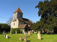 Church of St John the Baptist |
| Bere Court and Bere House | Bere Court Road, Pangbourne | House | Circa 13th century | 25 October 1951 | SU6163075016 51°28′15″N 1°06′51″W |
1213565 | |
| Donnington Castle | Castle Lane, Shaw cum Donnington | Castle | 1386 | 9 September 1969 | SU4611869170 51°25′11″N 1°20′17″W |
1291031 | |
| Shaw House | Church Road, Shaw cum Donnington | House | 1581 | 6 June 1952 | SU4756168369 51°24′44″N 1°19′03″W |
1220445 | |
| Gate Piers and Gates at Benham Park, West Lodge | Bath Road, Speen | Gate | Late 19th century | 6 June 1952 | SU4320968195 51°24′40″N 1°22′48″W |
1220645 | 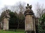 Gate Piers and Gates at Benham Park, West Lodge |
| Church of St Denys | Stanford Dingley | Church | 12th century | 29 November 1983 | SU5755471703 51°26′29″N 1°10′24″W |
1213251 | 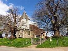 Church of St Denys |
| Church of St Mary | Sulhamstead | Church | 13th century | 28 January 1987 | SU6450667949 51°24′25″N 1°04′26″W |
1117112 | 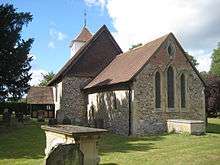 Church of St Mary |
| Folly Farmhouse and Entrance Court to East | Sulhamstead Hill, Sulhamstead | Country House | c. 1912 | 25 October 1951 | SU6308168917 51°24′57″N 1°05′39″W |
1135848 | |
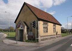
| Old Bluecoat School | Chapel Street, Thatcham | Chapel | 1304 | 10 November 1983 | SU5217967466 51°24′14″N 1°15′05″W |
1303195 | |
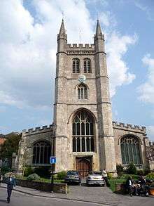
| Church of the Holy Trinity | Church Street, Theale | Church | 1820-1832 | 14 April 1967 | SU6402771290 51°26′13″N 1°04′49″W |
1288225 | .jpg) Church of the Holy Trinity |
| Church of St Laurence | A340 at Tidmarsh | Church | 12th century | 14 April 1967 | SU6348274552 51°27′59″N 1°05′15″W |
1287940 | 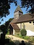 Church of St Laurence |
| Ufton Court | Ufton Nervet | House | c. 1568 | 25 October 1951 | SU6258866730 51°23′46″N 1°06′06″W |
1135879 | |
| Church of St Nicholas | Wasing Park, Wasing | Church | 13th century | 6 April 1967 | SU5759964271 51°22′28″N 1°10′26″W |
1117257 | 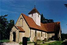 Church of St Nicholas |
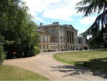
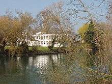
| Welford Park and walls to east and west | Welford | Country House | Late 17th century | 6 June 1952 | SU4084273168 51°27′22″N 1°24′49″W |
1264078 | 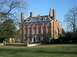 Welford Park and walls to east and west |
| West Woodhay House | West Woodhay | Country House | 1635 | 29 October 1984 | SU3850663253 51°22′01″N 1°26′54″W |
1290600 | |
| Church of St Peter and St Paul | Yattendon Lane, Yattendon | Church | c. 1450 | 14 April 1967 | SU5541874545 51°28′02″N 1°12′13″W |
1288822 |  Church of St Peter and St Paul |
.jpg)
_(14783846173).jpg)
.jpg)
.jpg)
Windsor and Maidenhead
| Name | Location | Type | Completed [note 1] | Date designated | Grid ref.[note 2] Geo-coordinates |
Entry number [note 3] | Image |
|---|---|---|---|---|---|---|---|
| Bisham Abbey | Marlow Road, Bisham | Manor house | 1537-1540 | 25 March 1955 | SU8468485021 51°33′28″N 0°46′47″W |
1303584 | |
| Dovecote Approximately 68 Metres South West of Bisham Abbey | Marlow Road, Bisham | Dovecote | 15th century | 25 March 1955 | SU8462684965 51°33′26″N 0°46′51″W |
1319381 | _%26_Sailing_School_(geograph_4408413).jpg) Dovecote Approximately 68 Metres South West of Bisham Abbey |
| Marlow Bridge | Marlow Road, Bisham | Suspension bridge | 1831-36 | 11 April 1972 | SU8513286079 51°34′02″N 0°46′23″W |
1117598 | |
| Jesus Hospital, including chaplain's house, the almshouses and the chapel | Upper Bray Road, Bray | Almshouse | 1627 | 25 March 1955 | SU9019479367 51°30′22″N 0°42′07″W |
1319439 | 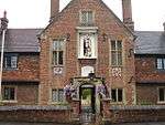 Jesus Hospital, including chaplain's house, the almshouses and the chapel |
| Maidenhead Bridge | Crossing River Thames from Maidenhead to Taplow, South Bucks | Road bridge | 1777 | 27 February 1950 | SU9014581356 51°31′26″N 0°42′07″W |
1117619 | |
| Monkey Island Hotel | Monkey Island Lane, Bray | Fishing Lodge | c. 1738 | 25 March 1955 | SU9144179148 51°30′14″N 0°41′02″W |
1319431 | |
| The Temple | Island Lane, Bray | Summerhouse | Early 18th century | 25 March 1955 | SU9127679023 51°30′10″N 0°41′11″W |
1117469 | |
| Ockwells Manor and wall attached on the South East | Ockwells Road, Cox Green | House | 1955 | 25 March 1955 | SU8750378886 51°30′08″N 0°44′27″W |
1319434 | 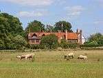 Ockwells Manor and wall attached on the South East |
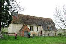
| Barn at Ockwells Manor | Ockwells Road, Cox Green | Threshing Barn | Late 15th century | 25 March 1955 | SU8756978919 51°30′09″N 0°44′23″W |
1136298 | |
| Dovecote at Ockwells Manor | Ockwells Road, Cox Green | Dovecote | Late 15th century | 25 March 1955 | SU8755678941 51°30′09″N 0°44′24″W |
1312870 | |
| Stables and gatehouse at Ockwells Manor | Ockwells Road, Cox Green | Stables and gatehouse | Late 15th century | 25 March 1955 | SU8755478890 51°30′08″N 0°44′24″W |
1117473 | |
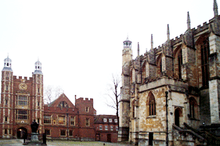
| Eton College | Eton | School | 1441-6 | 11 April 1950 | SU9648678220 51°29′41″N 0°36′42″W |
1290278 | |
| Church of St Michael | Stanwell Road, Horton | Parish Church | 12th century | 23 September 1955 | TQ0147475821 51°28′20″N 0°32′25″W |
1117644 | 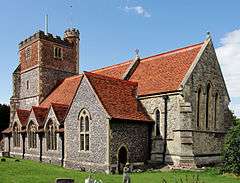 Church of St Michael |
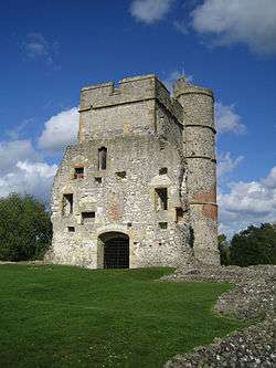
| Dovecote in the grounds of the Tithe Barn, about nine metres south of the house | High Street, Hurley | Dovecote | Medieval | 25 March 1955 | SU8248384004 51°32′56″N 0°48′43″W |
1156170 | 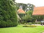 Dovecote in the grounds of the Tithe Barn, about nine metres south of the house |
| Hall Place | Burchetts Green Road, Hurley | House | Late 17th century | 25 March 1955 | SU8334881883 51°31′47″N 0°48′00″W |
1319394 | |
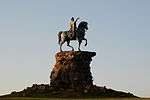
| Statue of George III | Windsor Great Park, Windsor | Statue | 1824-1830 | 3 March 1972 | SU9674472706 51°26′42″N 0°36′34″W |
1323671 | |
| Church of St John the Baptist | Shottesbrooke Park, Shottesbrooke | Parish Church | c. 1337 | 11 April 1972 | SU8414677103 51°29′12″N 0°47′22″W |
1319461 |  Church of St John the Baptist |
| Church of All Saints | Boyn Hill Road, Maidenhead | Church | 1854-1857 | 24 July 1970 | SU8775680872 51°31′12″N 0°44′12″W |
1117616 | |
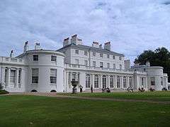
| Frogmore House | The Home Park, Windsor | House | Early 18th century | 2 October 1975 | SU9772075974 51°28′27″N 0°35′40″W |
1319304 | |
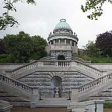
| Duchess of Kent's Mausoleum | The Home Park, Windsor | Mausoleum | 1861 | 2 October 1975 | SU9755475915 51°28′26″N 0°35′48″W |
1117780 | |
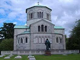
| The Royal Mausoleum | The Home Park, Windsor | Chest Tomb | 1864-68 | 2 October 1975 | SU9744575940 51°28′27″N 0°35′54″W |
1117781 | |
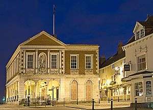
| Windsor Guildhall | High Street, Windsor | Town Hall | c. 1686 | 4 January 1950 | SU9682376831 51°28′56″N 0°36′25″W |
1117752 | |
| Windsor Castle including all the buildings within the walls | Windsor | Castle | Stone buildings 1165-1179 | 2 October 1975 | SU9700277033 51°29′02″N 0°36′16″W |
1117776 |  Windsor Castle including all the buildings within the walls |

.jpg)

Wokingham
| Name | Location | Type | Completed [note 1] | Date designated | Grid ref.[note 2] Geo-coordinates |
Entry number [note 3] | Image |
|---|---|---|---|---|---|---|---|
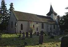
| Church of St James | Church Lane, Finchampstead | Parish Church | From 12th century | 26 January 1967 | SU7928263810 51°22′04″N 0°51′45″W |
1118084 |  Church of St James |
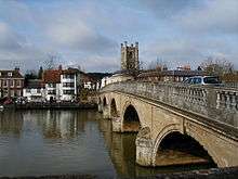
| Henley Bridge | Hart Street, Remenham | Bridge | 18th century | 23 December 1983 | SU7637582642 51°32′15″N 0°54′01″W |
1117419 | |
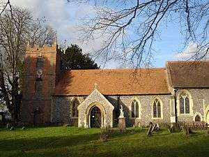
| Church of St James | Church Lane, Ruscombe | Parish Church | 12th century | 26 January 1967 | SU7980676295 51°28′48″N 0°51′08″W |
1154605 | 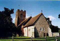 Church of St James |
| Church of St Mary the Virgin | Church Lane, Shinfield | Parish Church | Late 12th century | 26 January 1967 | SU7297368198 51°24′29″N 0°57′08″W |
1118131 | 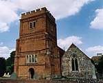 Church of St Mary the Virgin |
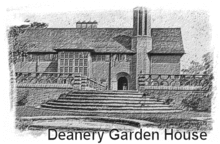
| The Deanery | Thames Street, Sonning | Courtyard House | 1901 | 1 August 1952 | SU7570575617 51°28′28″N 0°54′41″W |
1319459 | |
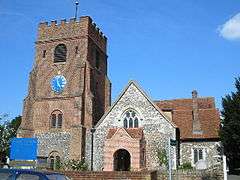
| Church of St Nicholas | Church Hill, Hurst | Parish Church | Early 13th century | 26 January 1967 | SU7948672972 51°27′01″N 0°51′27″W |
1117400 | 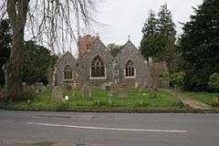 Church of St Nicholas |
| Church of All Saints | Church Road, Swallowfield | Church | 19th century | 26 January 1967 | SU7317464788 51°22′39″N 0°57′00″W |
1118061 | 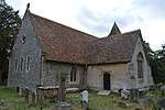 Church of All Saints |
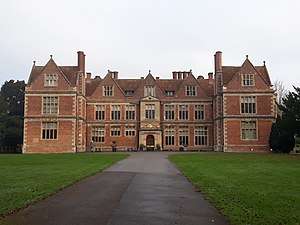
| Farley Hall | Farley Hill Road, Swallowfield | Country House | c. 1730 | 1 August 1952 | SU7501464627 51°22′33″N 0°55′25″W |
1118066 | |
| Henry Lucas Hospital and attached water pumps | Chapel Green, Wokingham | Hospital | 1663-1665 | 12 November 1951 | SU8125167394 51°23′59″N 0°50′00″W |
1303641 | .jpg) Henry Lucas Hospital and attached water pumps |
.jpg)
Notes
- The date given is the date used by Historic England as significant for the initial building or that of an important part in the structure's description.
- Sometimes known as OSGB36, the grid reference is based on the British national grid reference system used by the Ordnance Survey.
- The "List Entry Number" is a unique number assigned to each listed building and scheduled monument by Historic England.
References
- "Listed Buildings". English Heritage. 2010. Archived from the original on 24 January 2013. Retrieved 23 August 2011.
External links
![]()
Berkshire Portal | |
| Unitary authorities | |
| Major settlements | |
| Topics | |
This article is issued from Wikipedia. The text is licensed under Creative Commons - Attribution - Sharealike. Additional terms may apply for the media files.