Goliad Formation
The Goliad Formation (Tg)[1] is a geologic formation in Texas. It preserves fossils dating back to the Serravallian to earliest Pliocene stages (Clarendonian, Hemphillian and earliest Blancan in the NALMA classification) of the Neogene period,[2] including the gomphothere Blancotherium among many other fossil mammals, reptiles, birds and fish.
| Goliad Formation Stratigraphic range: Clarendonian-Blancan ~13.6–5.2 Ma | |
|---|---|
| Type | Formation |
| Sub-units | Lapara, Lagarto Creek & Labahia Members |
| Underlies | Pleistocene terrace deposits |
| Overlies | Fleming Formation |
| Thickness | 60–425 m (197–1,394 ft) |
| Lithology | |
| Primary | Sandstone, claystone |
| Other | Marl, caliche, limestone, conglomerate |
| Location | |
| Coordinates | 28.6°N 97.7°W |
| Approximate paleocoordinates | 29.0°N 95.3°W |
| Region | Bee, Goliad, Hidalgo & Live Oak counties, Texas |
| Country | |
| Extent | Texas coastal plain |
| Type section | |
| Named for | Goliad County |
| Named by | Plummer |
| Year defined | 1932 |
 Goliad Formation (the United States)  Goliad Formation (Texas) | |
The formation hosts uranium deposits and forms the Evangeline aquifer underneath the city of Houston.
Description

The Goliad Formation was described by Plummer in 1933,[3] as consisting of three members; the Lapara Sand, overlain by the Lagarto Creek Beds, in turn overlain by the Labahia Beds with outcrop thicknesses ranging from 35 to 200 feet (11 to 61 m).[4] The Goliad Formation comprises claystone, sand, sandstone, marl, caliche, limestone, and conglomerates and reaches in certain areas a thickness of 180 metres (590 ft).[5] The formation overlies the Fleming Formation and dates from the Clarendonian to the earliest Blancan.[6] In the southwest of its range, the formation overlies the Catahoula and Gueydan Formations.[7] The Goliad Formation is recognized regionally across the Texas coastal plain as an interval of dominantly fluvial siliciclastic strata that overlies the Miocene Fleming Formation and underlies Pleistocene terrace deposits. The formation is now interpreted as a basinward-thickening progradational wedge of Middle and Late Miocene age. Stratigraphic thicknesses in outcrop range from 60 to 120 metres (200 to 390 ft), but offshore the interval thickens to as much as 365 to 425 metres (1,198 to 1,394 ft).[4]
Together with the Catahoula, Fleming and Oakville Formation, the Goliad Formation is part of the Gulf Coast aquifer, an extensive artesian aquifer that produces water primarily for irrigation and municipalities.[8] The Evangeline aquifer is hosted by the Goliad Formation underlying the city of Houston.[9] The formation hosts uranium deposits in the South Texas Uranium Province and is mined for caliche in Hidalgo County, Texas.[5]
Fossil content
Tertiary mammal fossils from South Texas were first reported by Dumble (1894) as coming from the Lapara division, later the Lapara Beds (Dumble, 1903).[10]
The following fossils have been reported from the formation:[2]
| Group | Taxa | Notes | Images |
|---|---|---|---|
| Mammals | Aelurodon taxoides | [4] |  |
| Blancotherium buckneri | [4] | ||
| Calippus martini | |||
| Calippus placidus | |||
| Calippus regulus | |||
| Ceratogaulus rhinocerus | [4][11] |  | |
| Cormohipparion ingenuum | [12] | ||
| Cranioceras teres | [4] | 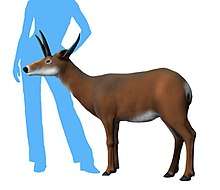 | |
| Dinohippus subvenus | 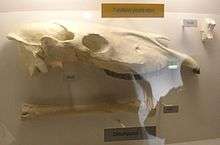 | ||
| Hipparion tehonense | [4] |  | |
| Hypohippus affine |  | ||
| Hypohippus affinis | |||
| Ischyrocyon gidleyi | [4] | ||
| Leptocyon vafer | 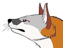 | ||
| Megatylopus primaevus |  | ||
| Neohipparion affine | .jpg) | ||
| Nothotylopus camptognathus | |||
| Pliohippus pernix | [4] | 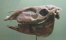 | |
| Procamelus grandis | 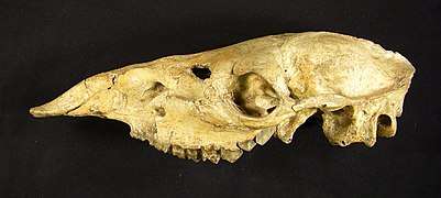 | ||
| Procamelus occidentalis | [4] | ||
| Prosthennops xiphidonticus | [4] | ||
| Protohippus supremus | [13] | _(14591795580).jpg) | |
| Protolabis coartatus | |||
| Pseudhipparion curtivallum | |||
| Pseudoceras skinneri | [4][14] | ||
| Ramoceros ramosus | [4] |  | |
| Synthetoceras tricornatus | [4] |  | |
| Teleoceras major | [15] | 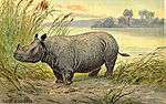 | |
| Ustatochoerus medius novomexicanus | |||
| Protolabis cf. yavapaiensis | [4] | ||
| Ustatochoerus cf. medius | [4] | ||
| Aepycamelus sp. | |||
| Amphicyon sp. | |||
| Aphelops sp. | |||
| Bison sp. | |||
| Blastomeryx sp. | |||
| Calippus sp. | |||
| Glyptodon sp. | |||
| Hypohippus sp. | |||
| Hippotherium sp. | [13] | ||
| Hypolagus sp. | |||
| Megatylopus sp. | |||
| Merychippus sp. | |||
| Merychyus sp. | |||
| Merycodus sp. | |||
| Nannippus sp. | |||
| Neohipparion sp. | |||
| Pliauchenia sp. | |||
| Pliohippus sp. | |||
| Procamelus sp. | |||
| Prosthennops sp. | |||
| Protolabis sp. | |||
| Teleoceras sp. | |||
| cf. Domninoides sp. | |||
| cf. Eucyon sp. | [4] | ||
| cf. Gomphotherium sp. | [4] | ||
| Amphicyoninae indet. | |||
| Merycodontinae indet. | |||
| Protoceratinae indet. | |||
| Tayassuinae indet. | [13] | ||
| Antilocapridae indet. | [13] | ||
| Canidae indet. | |||
| Equini indet. | |||
| Palaeomerycidae indet. | |||
| Protoceratidae indet. | [14] | ||
| Rhinocerotidae indet. | |||
| Rodentia indet. | |||
| Ruminantia indet. | [13] | ||
| cf. Mustelidae indet. | [4] | ||
| Birds | cf. Anserinae indet. | [4] | |
| Aves indet. | |||
| Reptiles | Alligator cf. mississippiensis | [4] |  |
| Apalone sp. | [4] | ||
| Hesperotestudo sp. | [4] | ||
| Testudo sp. | [4] | ||
| Trionyx sp. | |||
| cf. Gopherus sp. | [4] | ||
| cf. Mycteria sp. | [4] | ||
| cf. Terrapene sp. | [4] | ||
| cf. Trachemys sp. | [4] | ||
| Emydidae indet. | [4] | ||
| Fish | Pylodictis olivaris | [4] | 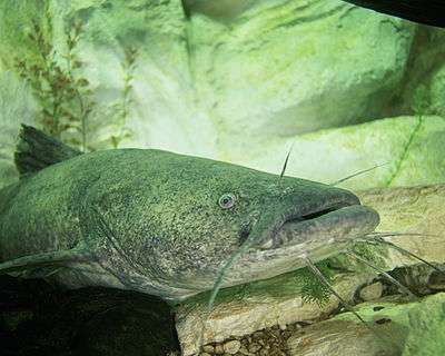 |
| Ictalurus cf. lambda | [4] | ||
| Ameiurus sp. | |||
| Lepisosteus sp. | [4] | ||
References
- Page et al., 2005, p.5
- Goliad Formation at Fossilworks.org
- Baskin & Hulbert, 2008, p.94
- May, 2019
- Page et al., 2005, p.7
- Baskin & Hulbert, 2008, p.96
- Nicot et al., 2010, p.38
- Page et al., 2005, p.4
- Campbell et al., 2018, p.14
- Baskin & Hulbert, 2008, p.93
- Baskin & Hulbert, 2012, p.187
- Baskin & Hulbert, 2008, p.97
- Alroy, 2002
- Webb, 2008
- Prothero, 2005
Bibliography
- Geology
- Campbell, Michael D.; M. David Campbell, and Henry M. Wise. 2018. Growth Faulting and Subsidence in the Houston, Texas Area: Guide to the Origins, Relationships, Hazards, Potential Impacts and Methods of Investigation: An Update. Journal of Geology and Geoscience 2. 1–51.
- Nicot, Jean-Philippe; Bridget R. Scanlon; Changbing Yang, and John B. Gates. 2010. Geological and Geographical Attributes of the South Texas Uranium Province, 1–156. Bureau of Economic Geology.
- Baskin, Jon, and Richard C. Hulbert. 2008. Revised Biostratigraphy of the Middle Miocene to Earliest Pliocene Goliad Formation of South Texas. Gulf Coast Association of Geological Societies 58. 93–101. Accessed 2020-07-08.
- Page, William R.; D. Paco VanSistine, and Kenzie J. Turner. 2005. Preliminary Geologic Map of Southernmost Texas, United States, and parts of Tamaulipas and Nuevo Leon, Mexico: Environmental Health Investigations in the United States-Mexico border region, 1–11. USGS. Accessed 2020-07-08.
- Paleontology
- May, S.R. 2019. The Lapara Creek Fauna: Early Clarendonian of south Texas, USA. Palaeontologia Electronica 22.1.15. 1-129.
- Baskin, Jon, and Richard C. Hulbert. 2012. A late Clarendonian local fauna from the Goliad Formation of South Texas. Paludicola 8. 187–193. Accessed 2020-07-08.
- Webb, S.D. 2008. Revision of the extinct Pseudoceratinae (Artiodactyla: Ruminantia: Gelocidae). Bulletin of the Florida Museum of Natural History 48. 17-58.
- Prothero, D.R. 2005. The Evolution of North American Rhinoceroses, 1-218. Cambridge University Press. ISBN 9781108457200
- Alroy, J. 2002. Synonymies and reidentifications of North American fossil mammals, .. ..
Further reading
- Weeks, A. W., 1945, Oakville, Cuero, and Goliad formations of Texas Coastal Plain between Brazos River and Rio Grande: American Association of Petroleum Geologists Bulletin, v. 29, p. 1721–1732
- E. H. Sellards. 1941. Final report covering the period from March 4, 1939 to September 30, 1941 for the state-wide paleontologic-mineralogic survey in Texas. A Federal Works Agency Work Projects Administration Project iii-85
- Anonymous. 1941. The ninth quarterly report covering the quarter ending June 30, 1941 for the state-wide paleontologic-mineralogic survey in Texas. A Federal Works Agency Work Projects Administration Project. O.P. No. 665-66-3-233. State Serial No. 300-88 1-41
- Anonymous. 1940. The seventh quarterly report covering the quarter ending December 31, 1940 for the state-wide paleontologic-mineralogic survey in Texas. A Federal Works Agency Work Projects Administration Project. O.P. No. 665-66-3-233. State Serial No. 300-88 1-44
- Anonymous. 1940. The sixth quarterly report covering the quarter ending September 30, 1940 for the state-wide paleontologic-mineralogic survey in Texas. A Federal Works Agency Work Projects Administration Project. O.P. No. 665-66-3-233. State Serial No. 300-88 1-44
- Anonymous. 1939. The second quarterly report covering the quarter ending September 30,1939 for the state-wide paleontologic-mineralogic survey in Texas. A Federal Works Agency Work Projects Administration Project. O.P. No. 665-66-3-233. State Serial No. 300-88 1-26
- Anonymous. 1939. The first quarterly report covering the quarter ending June 30,1939 for the state-wide paleontologic-mineralogic survey in Texas. A Federal Works Agency Work Projects Administration Project. O.P. No. 665-66-3-233. State Serial No. 300-88 1-22+