Florence, Kansas
Florence is a city in Marion County, Kansas, United States.[1] The city was named after the daughter of the third Governor of Kansas Samuel J. Crawford.[6] As of the 2010 census, the city population was 465.[7] It is located at the intersection of U.S. Route 50 and U.S. Route 77 highways.
Florence, Kansas | |
|---|---|
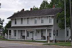
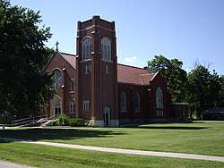 St Patrick Catholic Church (2010) | |
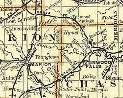
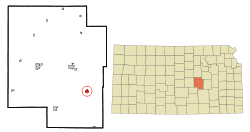 Location within Marion County and Kansas | |
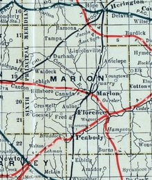
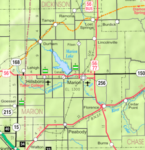 KDOT map of Marion County (legend) | |
| Coordinates: 38°14′34″N 96°55′46″W[1] | |
| Country | United States |
| State | Kansas |
| County | Marion |
| Township | Doyle, Fairplay |
| Platted | 1870 |
| Incorporated | 1872 |
| Named for | Florence Crawford |
| Government | |
| • Type | Mayor–Council |
| • Mayor | Robert Gayle [2] |
| Area | |
| • Total | 0.77 sq mi (1.99 km2) |
| • Land | 0.77 sq mi (1.98 km2) |
| • Water | 0.00 sq mi (0.00 km2) |
| Elevation | 1,270 ft (390 m) |
| Population | |
| • Total | 465 |
| • Estimate (2019)[5] | 435 |
| • Density | 567.89/sq mi (219.18/km2) |
| Time zone | UTC-6 (CST) |
| • Summer (DST) | UTC-5 (CDT) |
| ZIP code | 66851 |
| Area code | 620 |
| FIPS code | 20-23600 [1] |
| GNIS ID | 0477372 [1] |
| Website | FlorenceKS.com |
History
Early history
For millennia, the Great Plains of North America was inhabited by nomadic Native Americans. These tribes considered native included: the Arapaho, Cheyenne, Comanche, Kansa, Kiowa, Osage, Pawnee, and Wichita.[8] From the 16th century to 18th century, the Kingdom of France claimed ownership of large parts of North America. In 1762, after the French and Indian War, France secretly ceded New France to Spain, per the Treaty of Fontainebleau.
19th century
In 1802, Spain returned most of the land to France. In 1803, most of the land for modern day Kansas was acquired by the United States from France as part of the 828,000 square mile Louisiana Purchase for 2.83 cents per acre.
In 1806, Zebulon Pike led the Pike Expedition westward from St Louis, Missouri, of which part of their journey followed the Cottonwood River through Marion County near the current cities of Florence, Marion, Durham.[9]
In 1854, the Kansas Territory was organized, then in 1861 Kansas became the 34th U.S. state. In 1855, Marion County was established within the Kansas Territory, which included the land for modern day Florence.[10]
The first settlers in Marion County located on Doyle Creek, near the present site of Florence. They were Moses Shane, who came in 1858, and whose death the next year was the first in the county; Patrick Doyle, in 1859, for whom Doyle Creek and Township were named, and a family by the name of Welsh, in which occurred the first birth in the county in August 1859.[11] A post office existed in Doyle from November 26, 1866 to March 13, 1871.[12]
The Florence Town Company was a group of men who learned of the proposed route of the Atchison, Topeka and Santa Fe Railway, extended from Emporia, who decided on a town site where the railroad would cross the Cottonwood River. In September 23, 1870, there was announcement in The Emporia News about a new town named "Florence" at the mouth of Doyle Creek.[13] The Florence Town Company was formed on December 1, 1870 with Samuel J. Crawford as the president.[14] Previously, Crawford was the 3rd Governor of Kansas from 1865 to 1868. He named the town, Florence, in honor of his daughter, Miss Florence Crawford of Topeka.[6][15][16] The post office moved from Doyle to Florence on March 13, 1871.[12]
In 1871, the Atchison, Topeka and Santa Fe Railway extended a main line from Emporia through Florence to Newton.[17] In 1996, it merged with Burlington Northern Railroad and renamed to the current BNSF Railway. The Santa Fe depot building still exists, but has been closed for decades. Most locals still refer to this railroad as the "Santa Fe".
In 1877, the Florence, El Dorado, and Walnut Valley Railroad Company built a branch line from Florence to El Dorado, in 1881 it was extended to Douglass, and later to Arkansas City.[18] The line was leased and operated by the Atchison, Topeka and Santa Fe Railway. The line from Florence to El Dorado was abandoned in 1942.[19] The original branch line connected Florence, Burns, De Graff, El Dorado, Augusta, Douglass, Rock, Akron, Winfield, Arkansas City.
As early as 1875, city leaders of Marion held a meeting to consider a branch railroad from Florence. In 1878, the Marion and McPherson Railway Company was chartered.[18] In 1879, a branch line was built from Florence to McPherson, in 1880 it was extended to Lyons, in 1881 it was extended to Ellinwood.[20] The line was leased and operated by the Atchison, Topeka and Santa Fe Railway. The line from Florence to Marion, was abandoned in 1968.[21] In 1992, the line from Marion to McPherson was sold to Central Kansas Railway. In 1993, after heavy flood damage, the line from Marion to McPherson was abandoned. The original branch line connected Florence, Marion, Canada, Hillsboro, Lehigh, Canton, Galva, McPherson, Conway, Windom, Little River, Mitchell, Lyons, Chase, Ellinwood.
In 1877, Fred Harvey, an entrepreneur who is credited with establishing the first restaurant chain in the United States, bought the Clifton Hotel near the Florence railroad station for $5,370. Harvey redecorated the hotel and early in 1878, the second Harvey House Restaurant opened in Florence - the first Harvey House to offer sleeping rooms in addition to a restaurant.[22]
20th century
There have been numerous floods during the early history of Florence. In June and July 1951, due to heavy rains, rivers and streams flooded numerous cities in Kansas, including Florence. Many reservoirs and levees were built in Kansas as part of a response to the Great Flood of 1951. From 1964 to 1968, the Marion Reservoir was constructed north-west of Marion. Downstream from the Marion Reservoir, levees were built in low-lying areas of Marion and Florence.
Geography
Florence is located at 38°14′34″N 96°55′46″W (38.242853, -96.929412),[1] in the scenic Flint Hills of the Great Plains. According to the United States Census Bureau, the city has a total area of 0.77 square miles (1.99 km2), all land.[23]
Climate
The climate in this area is characterized by hot, humid summers and generally mild to cool winters. According to the Köppen Climate Classification system, Florence has a humid subtropical climate, abbreviated "Cfa" on climate maps.[24]
Area events
- Florence Labor Day Celebration, 76th annual in 2013.
- Florence High School Alumni Banquet, 117th annual in 2013, Memorial Day Weekend
- Harvey House Picnic, 15th annual in June 2013.
- Tour de Florence, mountain bike tour of the Flint Hills area around Florence, held in October.
- Florence Farmers Market, Moses Shane Memorial Park (west of water tower), May through September, Tuesday 5:30PM to 7:30PM.
Area attractions
Florence has five buildings listed on the National Register of Historic Places (NRHP).
- 1876 Harvey House[25] (NRHP), 221 North Marion Street. Part of the first Fred Harvey House, of the Fred Harvey Company, which stood south of the Santa Fe railroad tracks until the early 1900s. The existing structure was the original part of the Clifton Hotel that was erected to serve passengers of the Atchison, Topeka and Santa Fe Railway as a permanent eating station and hotel for passengers. It was the first Harvey House to provide sleeping facilities.[26][27][28][29][30]
- 1881 Doyle Place[31] (NRHP), 0.3 miles (0.48 km) south of railroad track on Main Street. The house is a fine example of Italian Villa style and built from local quarried stone. The original owner, Patrick Doyle, was the source of the Doyle creek and township names. Not open to public.
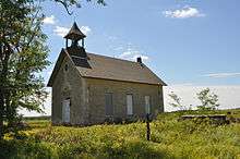
- 1896 Bichet School[32] (NRHP), 3 miles (4.8 km) east on US-50 then 0.1 miles (0.16 km) north on Bluestem Road. The school has a vernacular architecture built from local quarried stone. It was built to school French speaking immigrant children from a French settlement east of Florence that was settled from 1857 to 1885 by more than 60 families. Not open to public.
- 190x Florence Atchison, Topeka, & Santa Fe Depot (closed). Located at 38°14′20.1″N 96°55′39.5″W, which is north of the railroad tracks and south of the flood control dike. Not open to public.
- 1887 Florence Water Tower[33] (NRHP), 525 West 5th Street. Unique example of late 19th-century water tower constructed of local materials.
- 1949 Florence City Springs Pump House,[34] 1.25 miles (2.01 km) north. Not open to public.
- Florence Opera House (NRHP). Southwest corner of 5th and Main Streets.
Films and TV
- Feasting on Asphalt, 2006, season 1 episode 3 titled "High Plains Feaster", 7.5 minutes of video while Alton Brown visited the Spring Fling event and Harvey House in Florence.[35]
- Mary White, 1977, scenes from this TV movie about the daughter of Kansas journalist William Allen White, were filmed in Florence.
- Music Video, 2002, five day shoot around the 1896 Bichet School.[32]
Demographics
| Historical population | |||
|---|---|---|---|
| Census | Pop. | %± | |
| 1880 | 954 | — | |
| 1890 | 1,229 | 28.8% | |
| 1900 | 1,178 | −4.1% | |
| 1910 | 1,168 | −0.8% | |
| 1920 | 1,517 | 29.9% | |
| 1930 | 1,493 | −1.6% | |
| 1940 | 1,329 | −11.0% | |
| 1950 | 1,009 | −24.1% | |
| 1960 | 853 | −15.5% | |
| 1970 | 777 | −8.9% | |
| 1980 | 729 | −6.2% | |
| 1990 | 636 | −12.8% | |
| 2000 | 671 | 5.5% | |
| 2010 | 465 | −30.7% | |
| Est. 2019 | 435 | [5] | −6.5% |
| U.S. Decennial Census | |||
2010 census
As of the census[4] of 2010, there were 465 people, 216 households, and 118 families residing in the city. The population density was 603.9 inhabitants per square mile (233.2/km2). There were 279 housing units at an average density of 362.3 per square mile (139.9/km2). The racial makeup of the city was 95.1% White, 0.6% African American, 0.6% Native American, 0.2% Asian, 0.2% from other races, and 3.2% from two or more races. Hispanic or Latino of any race were 3.4% of the population.
There were 216 households of which 24.1% had children under the age of 18 living with them, 42.6% were married couples living together, 6.9% had a female householder with no husband present, 5.1% had a male householder with no wife present, and 45.4% were non-families. 39.8% of all households were made up of individuals and 17.2% had someone living alone who was 65 years of age or older. The average household size was 2.15 and the average family size was 2.87.
The median age in the city was 46.1 years. 21.7% of residents were under the age of 18; 6.7% were between the ages of 18 and 24; 20.3% were from 25 to 44; 32.2% were from 45 to 64; and 19.1% were 65 years of age or older. The gender makeup of the city was 50.3% male and 49.7% female.
2000 census
As of the census[36] of 2000, there were 671 people, 259 households, and 180 families residing in the city. The population density was 871.6 people per square mile (336.5/km2). There were 301 housing units at an average density of 391.0 per square mile (150.9/km2). The racial makeup of the city was 95.68% White, 0.75% African American, 0.60% Native American, 1.49% from other races, and 1.49% from two or more races. Hispanic or Latino of any race were 3.28% of the population.
There were 259 households out of which 24.3% had children under the age of 18 living with them, 56.0% were married couples living together, 9.7% had a female householder with no husband present, and 30.5% were non-families. 27.0% of all households were made up of individuals and 14.3% had someone living alone who was 65 years of age or older. The average household size was 2.37 and the average family size was 2.80.
In the city, the population was spread out with 21.6% under the age of 18, 5.5% from 18 to 24, 23.8% from 25 to 44, 27.0% from 45 to 64, and 22.1% who were 65 years of age or older. The median age was 44 years. For every 100 females, there were 84.8 males. For every 100 females age 18 and over, there were 84.6 males.
As of 2000 the median income for a household in the city was $26,538, and the median income for a family was $28,214. Males had a median income of $26,563 versus $20,208 for females. The per capita income for the city was $14,672. About 11.5% of families and 13.1% of the population were below the poverty line, including 19.1% of those under age 18 and 20.9% of those age 65 or over.
Government
The Florence government consists of a mayor and four council members. The council meets the 1st and 3rd Monday of each month at 6:30PM.[2][37]
- City Hall and Police Department, 511 N Main St.
- Fire Department.
- U.S. Post Office, 302 N Main St.
Education
Public
The community is served by Marion USD 408 public school district. Florence's schools have been closed and students attend schools in Marion. The high school is a member of T.E.E.N., a shared video teaching network between five area high schools.[38] All students attend schools in Marion.
- Marion High School, located in Marion.
- Marion Middle School, located in Marion.
- Marion Elementary School, located in Marion.
Florence schools were closed through school unification. The Florence High School mascot was Florence Wildcats.[39]
Library
The city is served by the Florence Public Library at 324 North Main Street. The library is a member of the North Central Kansas Libraries System, which provides an inter-library book loan service between its members.
Media
Print
- Peabody Gazette-Bulletin, local newspaper for Burns, Florence, Peabody.
- Marion County Record, local newspaper for Marion.
- Hillsboro Free Press, free newspaper for greater Marion County area.
- The El Dorado Times, regional newspaper from El Dorado.
- The Newton Kansan, regional newspaper from Newton.
Infrastructure
Transportation
Two highways cross through Florence: U.S. Routes 50 and 77. The intersection of these two highways had been known for numerous accidents in the past. In July 2003, two teen-agers died when they started crossing U.S. 50 and were struck by a semi-truck. By fall 2003, the Florence intersection was converted to a four-way stop with beacons and rumble strips. This solution lowered cross-traffic accidents, but increase rear-end collisions. To make the intersection safer, the Kansas Department of Transportation converted it into a 205-feet diameter roundabout, and completed it in September 2006.[40][41][42]
The BNSF Railway passes through Florence and runs nearly parallel to U.S. Route 50.
Utilities
- Internet
- Cable is provided by Eagle Communications.
- Wireless is provided by Pixius Communications.
- Satellite is provided by HughesNet, StarBand, WildBlue.
- TV
- Cable is provided by Eagle Communications.
- Satellite is provided by DirecTV, Dish Network.
- Terrestrial is provided by regional digital TV stations.
- Electricity
- Rural is provided by Flint Hills RECA.
- Water
- Service is provided by City of Florence.
- Sewer
- Service is provided by City of Florence.
- Trash
- Service is provided by City of Florence.
Notable people
- J. Ware Butterfield, (1838-1xxx), Kansas House of Representatives,[43][44] Lawyer
- Charles O. Fuller, (1825–1879), Kansas House of Representatives,[43] Businessman, Farmer
- J. K. McLean, (18xx-1xxx), Kansas House of Representatives[43]
- Sharon M. Savage, 1964 Miss Kansas, Miss Marion County Fair.
Famous visitors
- William Howard Taft, 27th President of the United States gave a campaign speech from his train, prior to 1908 election.
See also
References
- Geographic Names Information System (GNIS) details for Florence, Kansas; United States Geological Survey (USGS); October 13, 1978.
- "Florence - Directory of Public Officials". Archived from the original on 2012-03-08. Retrieved 2011-04-22.
- "2019 U.S. Gazetteer Files". United States Census Bureau. Retrieved July 24, 2020.
- "U.S. Census website". United States Census Bureau. Retrieved 2012-07-06.
- "Population and Housing Unit Estimates". United States Census Bureau. May 24, 2020. Retrieved May 27, 2020.
- Century of Pride, 1872-1972 : Florence Kansas Centennial; Florence Centennial Book Committee; 1972.
- "2010 City Population and Housing Occupancy Status". U.S. Census Bureau. Retrieved March 6, 2011.
- https://www.kshs.org/kansapedia/american-indians-in-kansas/17881
- "1806 Pike Expedition map through Marion County" (PDF). Archived from the original (PDF) on 2012-03-17. Retrieved 2011-06-01.
- The History of Marion County and Courthouse
- "Kansas: a cyclopedia of state history, embracing events, institutions, industries, counties, cities, towns, prominent persons, etc; Published 1912". Archived from the original on 2009-10-19. Retrieved 2010-06-30.
- "Kansas Post Offices, 1828-1961 (archived)". Kansas Historical Society. Archived from the original on October 9, 2013. Retrieved 14 June 2014.
- Announcement about new town named "Florence"; The Emporia News; September 23, 1870.
- Photo of Samuel Johnson Crawford in the 1860s; KansasMemory.org
- Illustration of Florence Crawford Capper between the 1880s and 1900s; KansasMemory.org
- Gannett, Henry (1905). The Origin of Certain Place Names in the United States. Govt. Print. Off. pp. 127.
- Santa Fe Rail History
- Marion County Kansas : Past and Present; Sondra Van Meter; MB Publishing House; LCCN 72-92041; 344 pages; 1972.
- Railway Abandonment 1942
- Fourth Annual Report of the Board of Railroad Commissioners for the Year Ending December 1, 1886 in State of Kansas; Kansas Publishing House; 1886.
- Railway Abandonment 1968
- http://www.kansastravel.org/harveyhousemuseum.htm
- "US Gazetteer files 2010". United States Census Bureau. Archived from the original on 2012-01-25. Retrieved 2012-07-06.
- Climate Summary for Florence, Kansas
- National Register of Historic Places - Harvey House
- Harvey House Intro
- Harvey House History
- Harvey House - Fred Harvey
- Harvey House - Harvey Girls
- Harvey House - Kansas Travel
- National Register of Historic Places - Doyle Place
- National Register of Historic Places - Bichet School
- National Register of Historic Places - Florence Water Tower
- Florence City Springs
- Feasting on Asphalt s01e03 High Plains Feaster - 7.5 minutes in Florence; youtube.com
- "U.S. Census website". United States Census Bureau. Retrieved 2008-01-31.
- Florence - Government
- T.E.E.N. video teaching network
- "Florence Finale", The Emporia Gazette, 17 November 1938, p.13.
- Kansas - High Speed Approach Rural Roundabouts; David Church of KDOT; May 11, 2007.
- Florence roundabout problems not unique; Marion County Record; January 16, 2008.
- Movement afoot to add roundabout at 56-77-150 junction; Hillsboro Free Press; December 27, 2011.
- Kansas Legislators Past & Present Archived August 1, 2010, at the Wayback Machine
- Transactions of the Kansas State Historical Society, Volume 7; W.Y. Morgan State Printer; 1902
Further reading
- 1872-1972 Century Of Pride - Florence Centennial - Florence, Kansas; 1972.[1]
- Florence 75th Anniversary edition; Florence Bulletin; June 5, 1947.
- A story of the Patrick Doyle family of Florence; A. B. MacDonald; The Kansas City Star; September 15, 1935.
- History of the Florence Catholic Church; E.H. Robison; Marion Review; September 13, 1933.
- Appetite for America - How Visionary Businessman Fred Harvey Built a Railroad Hospitality Empire That Civilized the Wild West; Stephen Fried; Bantam Books; ISBN 978-0-553-80437-9; 544 pages; March 23, 2010.[2]
External links
| Wikimedia Commons has media related to Florence, Kansas. |
- City
- Florence - Official
- Florence - Directory of Public Officials, League of Kansas Municipalities
- Florence Public Library
- Newspaper
- Peabody Gazette-Bulletin, local newspaper
- Historical
- Historic Images of Florence, Special Photo Collections at Wichita State University Library.
- AT&SF Railway Depot in Florence between 1900 and 1910
- Marion County cemetery list, archive of KsGenWeb
- Marion County history bibliography, Marion County school bibliography, Kansas Historical Society
- Lenora Graham - Meals on Wheels on YouTube, from Hatteberg's People on KAKE TV news
- Maps
- Florence City Map, KDOT
- Topo Map of Florence and south area, USGS
- Topo Map of Marion to Florence area, USGS
- Marion County Maps: Current, Historic, KDOT
Municipalities and communities of Marion County, Kansas, United States | ||
|---|---|---|
| Cities | 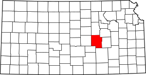 Map of Kansas highlighting Marion County | |
| Unincorporated communities | ||
| Ghost towns | ||
| Townships | ||
| Footnotes | ‡This populated place also has portions in an adjacent county or counties | |