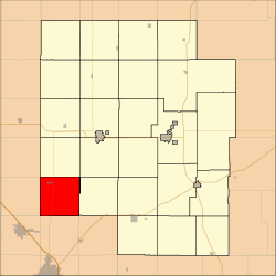
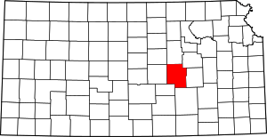
West Branch Township, Marion County, Kansas
West Branch Township is a township in Marion County, Kansas, United States. As of the 2010 census, the township population was 966, including the city of Goessel.[1]
West Branch Township Marion County, Kansas | |
|---|---|
 Location within Marion County | |
 West Branch Township Marion County, Kansas Location within the state of Kansas | |
| Coordinates: 38°13′30″N 097°19′35″W | |
| Country | United States |
| State | Kansas |
| County | Marion |
| Area | |
| • Total | 36 sq mi (90 km2) |
| Dimensions | |
| • Length | 6.0 mi (9.7 km) |
| • Width | 6.0 mi (9.7 km) |
| Elevation | 1,539 ft (469 m) |
| Population | |
| • Total | 966 |
| • Density | 27/sq mi (10/km2) |
| Time zone | UTC−06:00 (CST) |
| • Summer (DST) | UTC−05:00 (CDT) |
| Area code | 620 |
| FIPS code | 20-76775 [2] |
| GNIS feature ID | 477348 [3] |
| Website | County Website |
Geography
West Branch Township covers an area of 36 square miles (93.2 km2).
Cemeteries
The township contains the following cemeteries:
- Emmethal Community Cemetery, located in Section 29 T29S R1E.[4]
- General Conference of Mennonite Church of North America Cemetery, located in Section 27 T21S R1E.[4]
- Goessel Cemetery (1 block south of Main St on Cedar St), located in Section 5 T21S R1E.[4]
- Goessel Mennonite Brethren Cemetery, located in Section 8 T21S R1E.[4]
- Greenfield Cemetery (a.k.a. Greunfeld Cemetery), located in Section 16 T21S R1E.[4]
- Schoenthal Cemetery, located in Section 35 T21S R1E.[4]
- Tabor Mennonite Cemetery, located in Section 21 T21S R1E.[4]
- Green Valley Cemetery (a.k.a. Quiring Cemetery) (a.k.a. West Branch Gravesite), located in Section 11 T21S R1E.[4]
- Heibert Farm Cemetery, located in Section 27 T21S R1E.[4]
- Voth Cemetery, located in Section 1 T21S R1E.[4]
- Unknown Cemetery (no longer in use), located in Section 36 T21S R1E.[4]
Further reading
gollark: Some technologies lead more easily to harm than others.
gollark: That sounds like another thing which is bound to have no negative consequences.
gollark: I don't have those. I just do computers. Besides, bioweapons could affect other people.
gollark: I would recommend against entering the field of bioweapon design.
gollark: I'm pretty sure lots of viruses cover themselves (partly) in marker proteins from human cells, so it's harder to deal with them.
References
- "2010 Total Population - Township of West Branch". U.S. Census Bureau. Archived from the original on February 10, 2020. Retrieved June 17, 2013.
- "U.S. Census website". United States Census Bureau. Retrieved 2011-05-14.
- U.S. Geological Survey Geographic Names Information System: Township of West Branch
- Marion County Cemetery List.
- Marion County Highway Map; KSDOT.
External links
- Marion County Website
- City-Data.com
- Marion County Maps: Current, Historic, KDOT
This article is issued from Wikipedia. The text is licensed under Creative Commons - Attribution - Sharealike. Additional terms may apply for the media files.
