Fledborough Viaduct
Fledborough Viaduct is a former railway viaduct near Fledborough, Nottinghamshire.
| Lancashire, Derbyshire & East Coast Railway | |||||||||||||||||||||||||||||||||||||||||||||||||||||||||||||||||||||||||||||||||||||||||||||||||||||||||||||||||||||||||||||||||||||||||||||||||||||||||||||||||||||||||||||||||||||||||||||||||||||||||||||||||||||||||||||||||||||||||||||||||||||||||||||||||||||||||||||||||||||||||||||||||||||||||||||||||||||||||||||||||||||||||||||||||||||||||||||||||||||||||||||||||||||||||||||||||||||||||||||||||||||||||||||||||||||||||||||||||||||||||||||||||||||||||||||||||||||||||||||||||||||||
|---|---|---|---|---|---|---|---|---|---|---|---|---|---|---|---|---|---|---|---|---|---|---|---|---|---|---|---|---|---|---|---|---|---|---|---|---|---|---|---|---|---|---|---|---|---|---|---|---|---|---|---|---|---|---|---|---|---|---|---|---|---|---|---|---|---|---|---|---|---|---|---|---|---|---|---|---|---|---|---|---|---|---|---|---|---|---|---|---|---|---|---|---|---|---|---|---|---|---|---|---|---|---|---|---|---|---|---|---|---|---|---|---|---|---|---|---|---|---|---|---|---|---|---|---|---|---|---|---|---|---|---|---|---|---|---|---|---|---|---|---|---|---|---|---|---|---|---|---|---|---|---|---|---|---|---|---|---|---|---|---|---|---|---|---|---|---|---|---|---|---|---|---|---|---|---|---|---|---|---|---|---|---|---|---|---|---|---|---|---|---|---|---|---|---|---|---|---|---|---|---|---|---|---|---|---|---|---|---|---|---|---|---|---|---|---|---|---|---|---|---|---|---|---|---|---|---|---|---|---|---|---|---|---|---|---|---|---|---|---|---|---|---|---|---|---|---|---|---|---|---|---|---|---|---|---|---|---|---|---|---|---|---|---|---|---|---|---|---|---|---|---|---|---|---|---|---|---|---|---|---|---|---|---|---|---|---|---|---|---|---|---|---|---|---|---|---|---|---|---|---|---|---|---|---|---|---|---|---|---|---|---|---|---|---|---|---|---|---|---|---|---|---|---|---|---|---|---|---|---|---|---|---|---|---|---|---|---|---|---|---|---|---|---|---|---|---|---|---|---|---|---|---|---|---|---|---|---|---|---|---|---|---|---|---|---|---|---|---|---|---|---|---|---|---|---|---|---|---|---|---|---|---|---|---|---|---|---|---|---|---|---|---|---|---|---|---|---|---|---|---|---|---|---|---|---|---|---|---|---|---|---|---|---|---|---|---|---|---|---|---|---|---|---|---|---|---|---|---|---|---|---|---|---|---|---|---|---|---|---|---|---|---|---|---|---|---|---|---|---|---|---|---|---|---|---|---|---|---|---|---|---|---|---|---|---|---|---|---|---|---|---|---|---|---|---|---|---|---|---|---|---|---|---|---|---|---|---|
| |||||||||||||||||||||||||||||||||||||||||||||||||||||||||||||||||||||||||||||||||||||||||||||||||||||||||||||||||||||||||||||||||||||||||||||||||||||||||||||||||||||||||||||||||||||||||||||||||||||||||||||||||||||||||||||||||||||||||||||||||||||||||||||||||||||||||||||||||||||||||||||||||||||||||||||||||||||||||||||||||||||||||||||||||||||||||||||||||||||||||||||||||||||||||||||||||||||||||||||||||||||||||||||||||||||||||||||||||||||||||||||||||||||||||||||||||||||||||||||||||||||||
Fledborough Viaduct | |
|---|---|
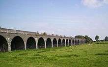 Fledborough Viaduct in 2008 | |
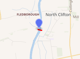
| Coordinates | 53°14′7.0″N 0°46′43.5″W |
| Carries | Ex-Lancashire, Derbyshire and East Coast Railway |
| Crosses | River Trent |
| Locale | Fledborough / North Clifton, Nottinghamshire |
| Maintained by | Sustrans |
| Characteristics | |
| Design | 59 brick arches; 4 trussed steel girder spans |
| Total length | 814 metres (890 yd) |
| Width | Twin Standard Gauge Rail |
| History | |
| Designer | Robert Elliott-Cooper |
| Opened | 1897 |
| Closed | 21 February 1980 |
| |
Context
The viaduct is a substantial structure which carried the double-track LD&ECR's Chesterfield Market Place to Lincoln Central main line over the River Trent.[1]
It is situated between the former stations of Fledborough and Clifton-on-Trent, but nearer the latter.
Opened in 1897, it consists of 59 arches spread either side of four metal girder spans which cross the river itself. Nine million bricks were used in its construction which cost £65,000.[2]
Timetabled passenger services over the viaduct ended in September 1955, though summer weekend excursions from Nottinghamshire and Derbyshire to Cleethorpes and Mablethorpe and from Manchester Central to Yarmouth Vauxhall continued until 1964.[3][4][5]
From the 1960s traffic east of Langwith Junction was overwhelmingly coal, much of which went straight from collieries to High Marnham Power Station which opened in 1959, this traffic therefore turned off about half a mile before the viaduct. The Grimsby to Whitland express fish train ran until at least 1962 via Fledborough[6] and through Mansfield Central.
Traffic continued to run over the viaduct until 21 February 1980 when a train derailed at Clifton-on-Trent. The line from Pyewipe Junction over the viaduct to High Marnham was closed "temporarily" the next day[7] and has subsequently been lifted.
Traffic continued from the West to High Marnham until it closed in 2003. Remarkably, since 2009 that stretch of line has had a new lease of life as Network Rail's High Marnham Test Track.
Modern Times
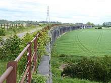
Today the railway trackbed eastwards from the site of Fledborough station, across the viaduct, through Clifton to Doddington & Harby forms an off-road part of National Cycle Route 647 which is part of the National Cycle Network.
From Harby onwards through the site of Skellingthorpe almost to Pyewipe Junction the trackbed forms an off-road part of National Cycle Route 64.[8] [9]
See also
References
- NoAuthor 2011, p. 16.
- Cupit & Taylor 1984, p.22 and centrepiece.
- Walker 1991, inside front cover.
- Working Timetable 1964 (Up): via flickr
- Working Timetable 1964 (Down): via flickr
- Walker 1991, Plate 120.
- Ludlam 2013, p. 144.
- Harby to Lincoln NR64: via sustrans
- Fledborough to Lincoln by Bike: via cycle-route
Sources
- Booth, Chris (2013). The Lancashire, Derbyshire and East Coast Railway A pictorial view of the "Dukeries Route" and branches. Two: Langwith Junction to Lincoln, the Mansfield Railway and Mid Nott's Joint Line. Blurb. ISBN 978-1-78155-660-3. 06884827.CS1 maint: ref=harv (link)
- Cupit, J.; Taylor, W. (1984) [1966]. The Lancashire, Derbyshire & East Coast Railway. Oakwood Library of Railway History (2nd ed.). Headington: Oakwood Press. ISBN 978-0-85361-302-2. OL19.CS1 maint: ref=harv (link)
- Dow, George (1965). Great Central, Volume Three: Fay Sets the Pace, 1900–1922. Shepperton: Ian Allan. ISBN 978-0-7110-0263-0. OCLC 500447049.
- Ludlam, A.J. (March 2013). Kennedy, Rex (ed.). "The Lancashire, Derbyshire & East Coast Railway". Steam Days. Bournemouth: Redgauntlet 1993 Publications. 283. ISSN 0269-0020.CS1 maint: ref=harv (link)
- NoAuthor (2011) [1948]. British Railways Atlas 1947: The Last Days of the Big Four. Shepperton: Ian Allan Publishing. ISBN 978-0-7110-3643-7.CS1 maint: ref=harv (link)
- Walker, Colin (1991). Eastern Region Steam Twilight, Part 2, North of Grantham. Llangollen: Pendyke Publications. ISBN 978-0-904318-14-2.CS1 maint: ref=harv (link)
External links
- Fledborough Viaduct on old OS map npemaps
- Fledborough Viaduct signalling and trackwork plus High Marnham Power Station signalboxes
- Fledborough Viaduct resumee and photo forgottenrelics
- Fledborough Viaduct photos and bibliography transportheritage
- Fledborough Viaduct photos oldminer
- Fledborough Viaduct and High Marham Power Station neolithicsea
- Fledborough Viaduct and Dukeries Trail nottinghamshire