List of crossings of the River Trent

This is a list of crossings of the River Trent, a major river flowing through the Midlands of England.

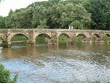
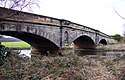
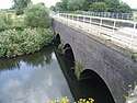
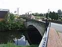
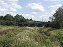
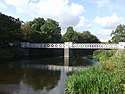
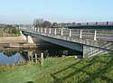
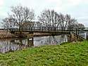
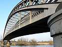
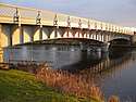
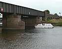
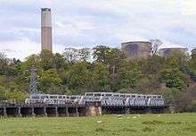
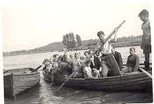
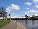
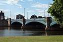
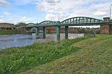
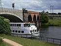
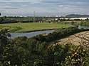
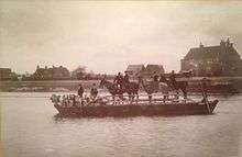
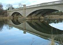
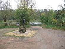
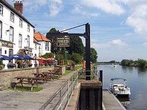
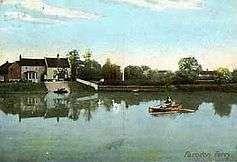
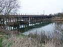
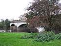
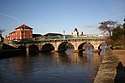
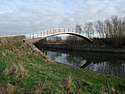
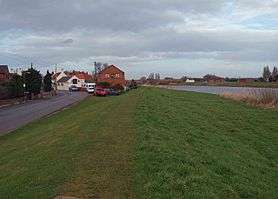
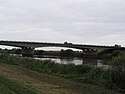
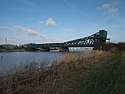
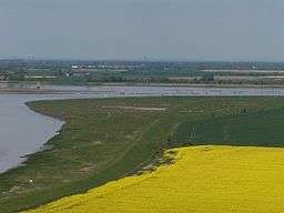
The table lists crossings that have been identified downstream from the River Sow confluence, the first major tributary on the river. Starting at Essex Bridge it includes ferries; road, rail, foot and pipe bridges found along the river to Trent Falls. Fords are only indicated where they predate a known crossing point. In Downstream (2008), author Tom Fort notes that over eighty historic crossings have been identified, most of which were fords or ferries.[1] In The River Trent (2005), author Richard Stone stated that "there are around seventy bridges across the Trent".[2] Each crossing has been marked with its river mileage with mile zero at Essex Bridge, reaching 140 miles (230 km) at Trent Falls.[3][4][5][6][7][8][9] Along the lower reaches, marker boards in kilometres show the distance from Nottingham.[8]

Crossings

River Miles (km) Name Image From /To County
Coordinates
Carries Date Ford Ferry Bridge Notes & refs
0
(0)
Essex BridgeGreat Haywood
Shugborough Hall
Staffordshire
52.80070°N 2.00860°W / 52.80070; -2.00860 (Essex Bridge)
BridlewayFordPackhorseGrade I Scheduled monument possibly 16th century[10]
1
(1.6)
Shugborough ViaductShugborough
Colwich
Staffordshire
52.78758°N 2.00281°W / 52.78758; -2.00281 (Shugborough Viaduct)
Trent Valley lineRailway[11][12]
1.3
(2.1)
Weetman's BridgeLittle Haywood
Cannock Chase
Staffordshire
52.78449°N 1.99578°W / 52.78449; -1.99578 (Weetman's Bridge)
Meadow Lane1888FordRoadReplaced earlier wooden bridge built in 1830.[12]
2.3
(3.7)
Wolseley BridgeWolseley
Colwich
Staffordshire
52.781046°N 1.971018°W / 52.781046; -1.971018 (Wolseley Bridge)
A511799RoadGrade II[12]
4.1
(6.6)
Rugeley Bypass bridge (north)Rugeley
Rugeley
Staffordshire
52.7755°N 1.9451°W / 52.7755; -1.9451 (Rugeley Bypass bridge (north))
A512007RoadRugeley bypass.[13]
4.3
(6.9)
Brindley Bank AqueductRugeley
Rugeley
Staffordshire
52.77350°N 1.94318°W / 52.77350; -1.94318 (Brindley Bank Aqueduct)
Trent and Mersey CanalCanal Aqueduct[12]
5.2
(8.4)
Rugeley Bypass bridge (east)Colton
Rugeley
Staffordshire
52.76760°N 1.93168°W / 52.76760; -1.93168 (Rugeley Bypass bridge (east))
A512007RoadRugeley bypass.[13]
5.3
(8.5)
Colton Mill BridgeColton
Rugeley
Staffordshire
52.767778°N 1.929365°W / 52.767778; -1.929365 (Colton Mill Bridge)
Colton Rd1800sRoadGrade II bridge.[12]
5.8
(9.3)
Rugeley railway bridgeColton
Rugeley
Staffordshire
52.76378°N 1.92556°W / 52.76378; -1.92556 (Rugeley railway bridge)
Chase LineRailway[12]
7.2
(11.6)
Mavesyn Ridware railway bridgeMavesyn Ridware
Armitage
Staffordshire
52.75062°N 1.89326°W / 52.75062; -1.89326 (Mavesyn Ridware railway bridge)
Trent Valley lineRailway[12]
7.7
(12.4)
Mavesyn Ridware footbridgeMavesyn Ridware
Armitage
Staffordshire
52.74668°N 1.88487°W / 52.74668; -1.88487 (Mavesyn Ridware footbridge)
Footpath1866Pedestrian[14]
8.5
(13.7)
High Bridge (new)Mavesyn Ridware
Armitage
Staffordshire
52.74824°N 1.86513°W / 52.74824; -1.86513 (High Bridge (new))
B5014RoadModern span.[14]
8.5
(13.7)
High BridgeMavesyn Ridware
Handsacre
Staffordshire
52.7484°N 1.86516°W / 52.7484; -1.86516 (High Bridge)
Footpath1830PedestrianGrade II*, modern span adjacent.[14]
9.2
(14.8)
Nethertown pipe bridge (north)Nethertown
Kings Bromley
Staffordshire
52.755402°N 1.840655°W / 52.755402; -1.840655 (Nethertown pipe bridge (north))
PipelinePipe[3]
9.7
(15.6)
Nethertown footbridgeNethertown
Kings Bromley
Staffordshire
52.75401°N 1.83968°W / 52.75401; -1.83968 (Nethertown footbridge)
FootpathPedestrian[14]
9.8
(15.8)
Nethertown pipe bridge (south)Nethertown
Kings Bromley
Staffordshire
52.75376°N 1.83908°W / 52.75376; -1.83908 (Nethertown pipe bridge (south))
PipelinePipe[3]
11.2
(18.0)
Kings Bromley footbridgeKings BromleyStaffordshire
52.752101°N 1.822489°W / 52.752101; -1.822489 (Kings Bromley footbridge)
FootpathPedestrian[3]
12.8
(20.6)
Yoxall BridgeYoxall
Kings Bromley
Staffordshire
52.757305°N 1.807311°W / 52.757305; -1.807311 (Yoxall Bridge)
Minor roadRoadGrade II, modern span adjacent.[14]
12.8
(20.6)
Yoxall Bridge (new)Yoxall
Kings Bromley
Staffordshire
52.75723°N 1.80703°W / 52.75723; -1.80703 (Yoxall Bridge (new))
A5151998RoadModern span.[14]
16.8
(27.0)
Cotton Close mill bridgeAlrewasStaffordshire
52.73627°N 1.75285°W / 52.73627; -1.75285 (Cotton Close mill bridge)
Access roadRoadAlrewas Mill.[3]
16.9
(27.2)
Statfold Lane millstream bridgeWychnor
Alrewas
Staffordshire
52.73500°N 1.75049°W / 52.73500; -1.75049 (Statfold Lane millstream)
Farm trackRoadBailey bridge, built by Transco in 1969.[15]
16.9
(27.2)
Statfold Lane river bridgeWychnor
Alrewas
Staffordshire
52.73727°N 1.75057°W / 52.73727; -1.75057 (Statfold Lane river)
Farm trackRoadBailey bridge, also built by Transco in 1969.[15]
17
(27)
Alrewas footbridgeWychnor
Alrewas
Staffordshire
52.73771°N 1.74708°W / 52.73771; -1.74708 (Alrewas footbridge)
TowpathPedestrianTrent and Mersey Canal towpath.[16]
17.9
(28.8)
Wychnor BridgesWychnor
Alrewas
Staffordshire
52.73968°N 1.73019°W / 52.73968; -1.73019 (Wychnor Bridges)
A38 roadFordRoadDual carriageway bridges replaced earlier bridges.[17]
18.6
(29.9)
Catholme viaductWychnor
Alrewas
Staffordshire
52.73495°N 1.72030°W / 52.73495; -1.72030 (Catholme viaduct)
South Staffordshire lineRailway[17]
18.7
(30.1)
Wichnor ViaductWychnor
Alrewas
Staffordshire
52.7339°N 1.71818°W / 52.7339; -1.71818 (Wichnor Viaduct)
Cross Country Route1839Railway[17]
18.8
(30.3)
Mythaholme BridgeWychnor
Alrewas
Staffordshire
52.73363°N 1.71776°W / 52.73363; -1.71776 (Mythaholme Bridge)
Footpath2004PedestrianNear National Memorial Arboretum.[17]
21.3
(34.3)
Walton BridgeBarton
Walton
Staffordshire
Derbyshire
52.7613°N 1.6843°W / 52.7613; -1.6843 (Walton Bridge)
Station Lane1974FordFerryRoadBailey bridge.[18]
24.7
(39.8)
Drakelow ViaductBranston
Drakelow
Staffordshire
Derbyshire
52.78668°N 1.63835°W / 52.78668; -1.63835 (Drakelow Viaduct)
Leicester lineRailwayLeicester Line bridge.[19]
25.5
(41.0)
Ferry BridgeBurton upon Trent
Stapenhill
Staffordshire
52.79457°N 1.626021°W / 52.79457; -1.626021 (Ferry Bridge)
FootpathFordFerryPedestrianGrade II.[20]
25.6
(41.2)
St Peter's BridgeBurton upon Trent
Stapenhill
Staffordshire
52.79546°N 1.62485°W / 52.79546; -1.62485 (St Peter's Bridge)
A51891985Road[20]
26.1
(42.0)
Andresey BridgeBurton upon Trent
Andressey Island
Staffordshire
52.802111°N 1.627034°W / 52.802111; -1.627034 (Andresey Bridge)
FootpathPedestrianGrade II bridge across Peel's Cut.[21]
26.2
(42.2)
Cattle BridgeBurton upon Trent
Andressey Island
Staffordshire
52.80259°N 1.62531°W / 52.80259; -1.62531 (Cattle Bridge)
FootpathPedestrianSpans Peel's Cut.[22]
26.5
(42.6)
Burton BridgeBurton upon Trent
Winshill
Staffordshire
52.80661°N 1.62309°W / 52.80661; -1.62309 (Burton Bridge)
A511RoadLeft Channel.[21]
27
(43)
Wetmore footbridge (south)Burton upon TrentStaffordshire
52.810289°N 1.624164°W / 52.810289; -1.624164 (Wetmore footbridge (south))
FootpathPedestrianLeft Channel.[4]
27.3
(43.9)
Wetmore pipe bridgeBurton upon TrentStaffordshire
52.81411°N 1.62320°W / 52.81411; -1.62320 (Wetmore pipe bridge)
PipelinePipeLeft Channel.[4]
27.6
(44.4)
Wetmore footbridge (north)Burton upon TrentStaffordshire
52.81716°N 1.62153°W / 52.81716; -1.62153 (Wetmore footbridge (north))
FootpathPedestrianLeft Channel.[4]
27.4
(44.1)
Burton Flour Mills bridgeWinshillStaffordshire
52.813498°N 1.611522°W / 52.813498; -1.611522 (Burton Flour Mills bridge)
Access roadRoadMillstream.[23]
27.5
(44.3)
Winshill pipe bridgeWinshillStaffordshire
52.81581°N 1.61034°W / 52.81581; -1.61034 (Winshill pipe bridge)
PipelinePipeRight Channel.[4]
30.4
(48.9)
Newton Solney pipe bridgeEgginton
Newton Solney
Derbyshire
52.83676°N 1.57961°W / 52.83676; -1.57961 (Newton Solney pipe bridge)
PipelinePipeWater pipeline.[24]
31.9
(51.3)
Willington BridgeWillington
Repton
Derbyshire
52.84794888°N 1.561398215°W / 52.84794888; -1.561398215 (Willington Bridge)
B50081839FordFerryRoadPreviously ferry and ford.[24]
34
(55)
Twyford FerryTwyford
Milton
Derbyshire
52.85257°N 1.51675°W / 52.85257; -1.51675 (Twyford Ferry)
FordFerry[24]
38.5
(62.0)
Swarkestone BridgeSwarkestone
Stanton by Bridge
Derbyshire
52.85288°N 1.45356°W / 52.85288; -1.45356 (Swarkestone Bridge)
A514RoadGrade I, Scheduled Monument, first mentioned in 1204.[25]
40.2
(64.7)
Weston-on-Trent viaductWeston-on-Trent
Kings Newton
Derbyshire
52.843712°N 1.423869°W / 52.843712; -1.423869 (viaduct)
Cloud Trail1867PedestrianPreviously a rail bridge.[26]
40.5
(65.2)
Weston Cliff FerryWeston-on-Trent
Kings Newton
Derbyshire
52.8412°N 1.4188°W / 52.8412; -1.4188 (Weston Cliff Ferry)
Ferry[27]
42.7
(68.7)
King's Mill FerryWeston-on-Trent
King's Mill
Derbys
Leics
52.84455°N 1.38290°W / 52.84455; -1.38290 (Kings Mill Ferry)
FordFerry[28]
43.6
(70.2)
Castle Donington railway viaductWeston-on-Trent
Castle Donington
Derbys
Leics
52.85158°N 1.36553°W / 52.85158; -1.36553 (Castle Donington railway viaduct)
Castle Donington lineRailway[5]
45
(72)
A50 Trent BridgeShardlow
Cavendish Bridge
Derbys
Leics
52.86101°N 1.34765°W / 52.86101; -1.34765 (A50 Trent Bridge)
A501997Road[5]
46.1
(74.2)
Cavendish BridgeShardlow
Cavendish Bridge
Derbys
Leics
52.86502°N 1.33722°W / 52.86502; -1.33722 (Cavendish Bridge)
B50101956FordFerryRoadWilden Ferry.[26]
47.3
(76.1)
Long Horse BridgeShardlow
Hemington
Derbys
Leics
52.87114°N 1.31918°W / 52.87114; -1.31918 (Long Horse Bridge)
Towpath2011Pedestrian[29]
47.5
(76.4)
Sawley AqueductSawley
Hemington
Derbys
Leics
52.87337°N 1.31464°W / 52.87337; -1.31464 (Sawley Aqueduct)
Derwent Valley Aqueduct1909Pipe[29]
47.7
(76.8)
M1 Trent viaductSawley
Hemington
Derbys
Leics
52.87342°N 1.30909°W / 52.87342; -1.30909 (M1 Trent viaduct)
M11967Road[29]
48.2
(77.6)
Harrington BridgeSawley
Hemington
Derbys
Leics
52.8754°N 1.3012°W / 52.8754; -1.3012 (Harrington Bridge)
B65401790FordFerryRoadGrade II bridge, replaced Sawley Ferry.[30]
48.6
(78.2)
Sawley railway viaductLong Eaton
Hemington
Derbys
Leics
52.87276°N 1.29065°W / 52.87276; -1.29065 (Sawley railway viaduct)
Castle Donington lineRailway[30]
49.4
(79.5)
Trent Lock Scout FerryTrent Lock
Scout Activity Centre
Derbys
Leics
52.87557°N 1.27536°W / 52.87557; -1.27536 (Trent Lock Scout Ferry)
1975FerryScout Activity Centre ferry.[31]
49.5
(79.7)
Trent Lock FerryTrent Lock
Ratcliffe-on-Soar
Derbys
Notts
52.87489°N 1.27115°W / 52.87489; -1.27115 (Trent Lock Ferry)
FerryHorse and passenger ferry.[32]
49.8
(80.1)
Redhill ViaductsLong Eaton
Thrumpton
Derbys
Notts
52.8735°N 1.26617°W / 52.8735; -1.26617 (Redhill Viaduct)
Midland Main Line1893RailwayTrent Viaducts.[30]
49.9
(80.3)
Thrumpton FerryLong Eaton
Thrumpton
Derbys
Notts
52.87914°N 1.24255°W / 52.87914; -1.24255 (Thrumpton Ferry)
Ferry[33]
52
(84)
Barton FerryAttenborough
Barton in Fabis
Nottinghamshire
52.89539°N 1.22949°W / 52.89539; -1.22949 (Barton Ferry)
FerryOperated until 1960s.[34]
56.5
(90.9)
Clifton BridgeNottingham
Clifton
Nottinghamshire
52.9251°N 1.1658°W / 52.9251; -1.1658 (Clifton Bridge)
A521958Road[35]
57.5
(92.5)
Wilford Toll BridgeThe Meadows
Wilford
Nottinghamshire
52.9377°N 1.1546°W / 52.9377; -1.1546 (Wilford Toll Bridge)
Nottingham Express Transit1870FerryRailwayWilford Ferry.[36]
58.3
(93.8)
Wilford Suspension BridgeThe Meadows
West Bridgford
Nottinghamshire
52.9332°N 1.1393°W / 52.9332; -1.1393 (Wilford Suspension Bridge)
Footpath1906PedestrianFootpath and pipelines[37]
58.6
(94.3)
Trent Bridge, NottinghamNottingham
West Bridgford
Nottinghamshire
52.938°N 1.136°W / 52.938; -1.136 (Trent Bridge, Nottingham)
A601871RoadThe current bridge is the last in a series of bridges at this important crossing point. A bridge was first mentioned in 924.[38]
58.8
(94.6)
Navigation BridgeNottingham
West Bridgford
Nottinghamshire
52.9403°N 1.1350°W / 52.9403; -1.1350 (Navigation Bridge)
TowpathPedestrianFormer horse bridge - damaged by the 1875 flood and subsequently demolished.[39]
58.9
(94.8)
Lady Bay BridgeNottingham
West Bridgford
Nottinghamshire
52.94283°N 1.13162°W / 52.94283; -1.13162 (Lady Bay Bridge)
A60111878RoadPreviously a rail bridge.[39]
60.5
(97.4)
Holme SluicesColwick
Holme Pierrepont
Nottinghamshire
52.94793°N 1.08799°W / 52.94793; -1.08799 (Holme Sluices)
Access1952SluicesPrivate bridge.[40]
62.7
(100.9)
Rectory Junction ViaductNetherfield
Radcliffe-on-Trent
Nottinghamshire
52.95116°N 1.054154°W / 52.95116; -1.054154 (Rectory Junction Viaduct)
Nottingham–Grantham line1850RailwayRadcliffe Viaduct.[41]
63.5
(102.2)
Radcliffe FerryStoke Bardolph
Radcliffe-on-Trent
Nottinghamshire
52.95133°N 1.04139°W / 52.95133; -1.04139 (Radcliffe Ferry)
Ferry[34]
64.2
(103.3)
Stoke Bardolph FerryStoke Bardolph
Shelford
Nottinghamshire
52.97276°N 1.03664°W / 52.97276; -1.03664 (Stoke Bardolph Ferry)
Ferry[34]
67.5
(108.6)
Gunthorpe BridgeGunthorpe
East Bridgford
Nottinghamshire
52.9862°N 0.9874°W / 52.9862; -0.9874 (Gunthorpe Bridge)
A60971925FordFerryRoadEarlier ford and ferry.[42]
71
(114)
Hoveringham FerryHoveringham
Kneeton
Nottinghamshire
53.00971°N 0.95174°W / 53.00971; -0.95174 (Hoveringham Ferry)
Ferry[34]
73.2
(117.8)
Hazelford FerryHazelford Ferry
Elston
Nottinghamshire
53.0324°N 0.9175°W / 53.0324; -0.9175 (Hazelford Ferry)
Ferry[34]
75.5
(121.5)
Fiskerton FerryFiskerton
East Stoke
Nottinghamshire
53.05152°N 0.90149°W / 53.05152; -0.90149 (Fiskerton Ferry)
Ferry[34]
78.5
(126.3)
Farndon FerryFarndon
Farndon
Nottinghamshire
53.06114°N 0.85604°W / 53.06114; -0.85604 (Farndon Ferry)
Ferry[43]
79.5
(127.9)
Averham ViaductStaythorpe
Newark-on-Trent
Nottinghamshire
53.07649°N 0.85048°W / 53.07649; -0.85048 (Averham Viaduct)
Nottingham–Lincoln lineRailwayKelham Arm[43]
80.9
(130.2)
Kelham BridgeKelham
Newark-on-Trent
Nottinghamshire
53.09244947°N 0.842654209°W / 53.09244947; -0.842654209 (Kelham Bridge)
A6171857RoadKelham Arm[44]
82
(132)
Muskham BridgeSouth Muskham
Newark-on-Trent
Nottinghamshire
53.09775°N 0.82521°W / 53.09775; -0.82521 (Muskham Bridge)
A616/Great North Road1922RoadKelham Arm[45][46]
82
(132)
Smeaton's ArchesSouth Muskham
Newark-on-Trent
Nottinghamshire
53.0901°N 0.82092°W / 53.0901; -0.82092 (Smeaton's Arches)
A616/Great North Road1772RoadCauseway links Muskham Bridge and Trent Bridge, Newark.[47]
82.7
(133.1)
Muskham ViaductSouth Muskham
Newark-on-Trent
Nottinghamshire
53.0976°N 0.8088°W / 53.0976; -0.8088 (Muskham Viaduct)
East Coast Main LineRailwayKelham Arm[48]
80.4
(129.4)
A46 Newark bypass, FarndonNewark-on-Trent
Farndon
Nottinghamshire
53.06717°N 0.83584°W / 53.06717; -0.83584 (A46 Newark bypass, Farndon)
A46 road1992Road[49]
81.2
(130.7)
Longstone BridgeNewark-on-TrentNottinghamshire
53.07445°N 0.818642°W / 53.07445; -0.818642 (Longstone Bridge)
Towpath1819Pedestrian[50]
81.3
(130.8)
Mill BridgeNewark-on-TrentNottinghamshire
53.0748°N 0.81732°W / 53.0748; -0.81732 (Mill Bridge)
Mill Lane1952Road[47]
81.4
(131.0)
Backwater Bridge, Newark-on-TrentNewark-on-TrentNottinghamshire
53.07695°N 0.81458°W / 53.07695; -0.81458 (Backwater Bridge, Newark-on-Trent)
Towpath1952Pedestrian[47]
81.6
(131.3)
Trent Bridge, NewarkNewark-on-TrentNottinghamshire
53.078544°N 0.812663°W / 53.078544; -0.812663 (Trent Bridge, Newark)
Great North Road1775Road[47]
81.8
(131.6)
Jubilee BridgeNewark-on-TrentNottinghamshire
53.08141°N 0.80876°W / 53.08141; -0.80876 (Jubilee Bridge)
Footpath2002Pedestrian[47]
82.2
(132.3)
Fiddler's Elbow BridgeNewark-on-TrentNottinghamshire
53.0872°N 0.804855°W / 53.0872; -0.804855 (Fiddler’s Elbow Bridge)
Towpath1915Pedestrian[47]
82.3
(132.4)
A46 Nether Lock ViaductNewark-on-TrentNottinghamshire
53.089°N 0.80481°W / 53.089; -0.80481 (A46 Nether Lock Viaduct)
A46 road1992Road[46]
82.4
(132.6)
Midland Railway ViaductNewark-on-TrentNottinghamshire
53.08902°N 0.80609°W / 53.08902; -0.80609 (Midland Railway Viaduct)
Nottingham–Lincoln line1846Railway[46]
82.6
(132.9)
Newark Dyke BridgeNorth Muskham
Newark-on-Trent
Nottinghamshire
53.09279°N 0.80606°W / 53.09279; -0.80606 (Newark Dyke Bridge)
East Coast Main Line2000Railway[46]
83.1
(133.7)
Winthorpe BridgeNorth Muskham
Winthorpe
Nottinghamshire
53.10164°N 0.7986°W / 53.10164; -0.7986 (Winthorpe Bridge)
A1Road[46]
86.2
(138.7)
Muskham FerryNorth Muskham
Holme
Nottinghamshire
53.12058°N 0.80803°W / 53.12058; -0.80803 (Muskham Ferry)
FordFerryOperated until the 1940s.[44]
87
(140)
Cromwell LockCromwellNottinghamshire
53.14137°N 0.79248°W / 53.14137; -0.79248 (Cromwell Lock)
Tidal limit.[51]
90.6
(145.8)
Carlton on Trent FerryCarlton-on-Trent
Collingham
Nottinghamshire
53.16824°N 0.80068°W / 53.16824; -0.80068 (Carlton on Trent Ferry)
Ferry[34]
92.6
(149.0)
Meering FerrySutton-on-Trent
Meering
Nottinghamshire
53.17846°N 0.78626°W / 53.17846; -0.78626 (Meering Ferry)
Ferry[2]
96.6
(155.5)
Marnham FerryHigh Marnham
South Clifton
Nottinghamshire
53.22416°N 0.78318°W / 53.22416; -0.78318 (Marnham Ferry)
Ferry[34]
96.9
(155.9)
Fledborough ViaductFledborough
North Clifton
Nottinghamshire
53.2353°N 0.77875°W / 53.2353; -0.77875 (Fledborough Viaduct)
Footpath1897PedestrianFormer rail bridge.[52]
97
(156)
Fledborough FerryFledborough
North Clifton
Nottinghamshire
53.24108°N 0.77818°W / 53.24108; -0.77818 (Fledborough Ferry)
Ferry[34]
99
(159)
Dunham BridgeDunham
Newton on Trent
Nottinghamshire
Lincolnshire
53.2608°N 0.773°W / 53.2608; -0.773 (Dunham Bridge)
A571832FerryRoadPreviously a ferry.[52]
99
(159)
Dunham pipe bridgeDunham
Newton on Trent
Nottinghamshire
Lincolnshire
53.2602°N 0.77312°W / 53.2602; -0.77312 (Dunham pipe bridge)
Pipeline1912Pipe[52]
101.4
(163.2)
Laneham FerryLaneham
Laughterton
Nottinghamshire
Lincolnshire
53.2815°N 0.7770°W / 53.2815; -0.7770 (Laneham Ferry)
FerryClosed in 1922.[34]
103.6
(166.7)
Torksey FerryRampton
Torksey
Nottinghamshire
Lincolnshire
53.3000°N 0.7489°W / 53.3000; -0.7489 (Torksey Ferry)
Ferry[53]
103.7
(166.9)
Torksey ViaductCottam
Torksey
Nottinghamshire
Lincolnshire
53.303°N 0.74819°W / 53.303; -0.74819 (Torksey Viaduct)
Footpath1849RailwayGrade II*, disused railway bridge.[54]
107.3
(172.7)
Littleborough FerryLittleborough
Marton
Nottinghamshire
Lincolnshire
53.33283°N 0.76156°W / 53.33283; -0.76156 (Littleborough Ferry)
FordFerryProbable Roman ford at Segelocum.[55]
110.7
(178.2)
Bole FerryBole
Lea
Nottinghamshire
Lincolnshire
53.36887°N 0.79058°W / 53.36887; -0.79058 (Bole Ferry)
Ferry[56]
112.2
(180.6)
Gainsborough Trent Junction railway bridgeBole
Gainsborough
Nottinghamshire
Lincolnshire
53.38387°N 0.78439°W / 53.38387; -0.78439 (Gainsborough Trent Junction railway bridge)
Railway1849RailwayRebuilt with new spans in 1992.[57][8]
113.5
(182.7)
Trent Bridge, GainsboroughBeckingham
Gainsborough
Nottinghamshire
Lincolnshire
53.3922°N 0.7766°W / 53.3922; -0.7766 (Trent Bridge, Gainsborough)
A6311791FerryRoadGrade II, earlier ferry and ford.[56]
116.7
(187.8)
Walkerith FerryWalkeringham
Walkerith
Nottinghamshire
Lincolnshire
53.4261°N 0.8175°W / 53.4261; -0.8175 (Walkerith Ferry)
Ferry[58]
117.5
(189.1)
Stockwith FerryWest Stockwith
East Stockwith
Nottinghamshire
Lincolnshire
53.44267°N 0.81327°W / 53.44267; -0.81327 (Stockwith Ferry)
FerryCeased around 1953.[59]
121.7
(195.9)
Owston FerryOwston Ferry
East Ferry
Lincolnshire
53.49020°N 0.77490°W / 53.49020; -0.77490 (Owston Ferry)
FerryCeased around 1951.[34]
126.6
(203.7)
Butterwick FerryWest Butterwick
East Butterwick
Lincolnshire
53.54087°N 0.73987°W / 53.54087; -0.73987 (Butterwick Ferry)
Ferry[34]
127.1
(204.5)
M180 Trent BridgeWest Butterwick
Burringham
Lincolnshire
53.55686°N 0.74623°W / 53.55686; -0.74623 (M180 Trent Bridge)
M1801979Road[60]
129
(208)
Althorpe FerryAlthorpe
Burringham
Lincolnshire
53.57652°N 0.73820°W / 53.57652; -0.73820 (Althorpe Ferry)
Ferry[34]
130
(210)
Keadby BridgeKeadby
Gunness
Lincolnshire
53.5857°N 0.7311°W / 53.5857; -0.7311 (Keadby Bridge)
A18
South Humberside Main Line
1916Road
Railway
Grade II Bascule bridge King George V Bridge.[60]
134.5
(216.5)
Amcotts FerryAmcotts
Flixborough
Lincolnshire
53.61768°N 0.70171°W / 53.61768; -0.70171 (Amcotts Ferry)
Ferry[61]
136.6
(219.8)
Garthorpe FerryGarthorpe
Burton upon Stather
Lincolnshire
53.65637°N 0.69460°W / 53.65637; -0.69460 (Garthorpe Ferry)
FerryAlso known as Burton Stather Ferry.[34]
140
(230)
Trent FallsOusefleet
Alkborough
53.6972°N 0.6957°W / 53.6972; -0.6957 (Trent Falls)Mouth of the Trent.[62]

Bibliography

  • Fort, Tom (2008). Downstream. Century. ISBN 978-1-84605-169-2.CS1 maint: ref=harv (link)
  • Stone, Richard (2005). The River Trent. Phillimore. ISBN 978-1-86077-356-3.CS1 maint: ref=harv (link)
  • Taylor, Mike (2000). The River Trent Navigation. Tempus Publishing. ISBN 0-7524-1743-6.CS1 maint: ref=harv (link)

References

  1. Fort 2008, p. 124.
  2. Stone 2005, p. 16.
  3. Taylor 2000, p. 24.
  4. Stone 2005, p. 58.
  5. Stone 2005, p. 59.
  6. Stone 2005, p. 60.
  7. Stone 2005, p. 61.
  8. Stone 2005, p. 62.
  9. Stone 2005, p. 63.
  10. Stone 2005, p. 64.
  11. Stone 2005, p. 65.
  12. Stone 2005, p. 66.
  13. Stone 2005, p. 67.
  14. Stone 2005, p. 69.
  15. Stone 2005, p. 70.
  16. Stone 2005, p. 73.
  17. Stone 2005, p. 71.
  18. Stone 2005, p. 72.
  19. Stone 2005, p. 74.
  20. Stone 2005, p. 75.
  21. Taylor 2000, p. 113.
  22. Stone 2005, p. 77.
  23. Stone 2005, p. 15.
  24. Stone 2005, p. 79.
  25. Stone 2005, p. 80.
  26. Stone 2005, p. 82.
  27. Stone 2005, p. 83.
  28. Stone 2005, p. 85.
  29. Stone 2005, p. 120.
  30. Stone 2005, p. 87.
  31. Stone 2005, p. 88.
  32. Stone 2005, p. 92.
  33. Stone 2005, p. 101.
  34. Stone 2005, p. 99.
  35. Stone 2005, p. 97.
  36. Stone 2005.
  37. Stone 2005, p. 93.
  38. Stone 2005, p. 98.
  39. Stone 2005, p. 103.
  40. Stone 2005, p. 104.
  41. Stone 2005, p. 106.
  42. Stone 2005, p. 107.
  43. Stone 2005, p. 108.
  44. Stone 2005, p. 109.
  45. Stone 2005, p. 14.
  46. Stone 2005, p. 113.
  47. Stone 2005, p. 116.
  48. Stone 2005, p. 118.
This article is issued from Wikipedia. The text is licensed under Creative Commons - Attribution - Sharealike. Additional terms may apply for the media files.